Vertoonende all de Zee-Kusten Van het bekende Deel des Aerd-Bodems, Met een generale beschrijvinge van dien. Seer dienstigh vooralle Schippers en Stuurlieden; mitsgaders Koop-lieden om op't Kantoor gebruykt te werden Nieuwelijks aldus uytgegeven.
Folio atlas (530 by 350mm), title, preface, index, 22pp. text, 31 double-page engraved charts, fine original outline hand-colour, heightened in gold, contemporary full calf, gilt fillet border, rebacked preserving original spine, gilt.
Although not the first to publish a sea atlas in Amsterdam – that honour went to Janssonius – the first edition of Doncker's 'Zee-Atlas', published in 1659, was superior both in coverage and utility to the rival publications of Johannes Janssonius and Arnold Colom, neither of which were reprinted after 1659.
Koeman notes: "Doncker's charts were the most up-to-date in the second half of the seventeenth century. Although there is some similarity to those charts pu...
Although not the first to publish a sea atlas in Amsterdam – that honour went to Janssonius – the first edition of Doncker's 'Zee-Atlas', published in 1659, was superior both in coverage and utility to the rival publications of Johannes Janssonius and Arnold Colom, neither of which were reprinted after 1659.
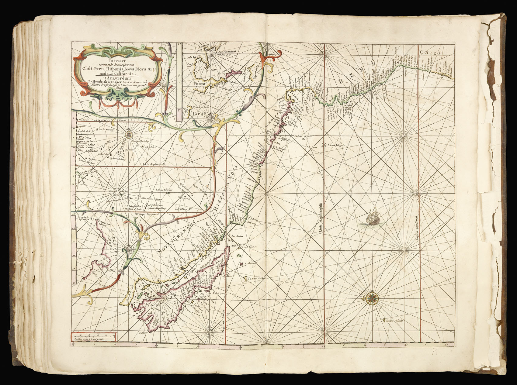
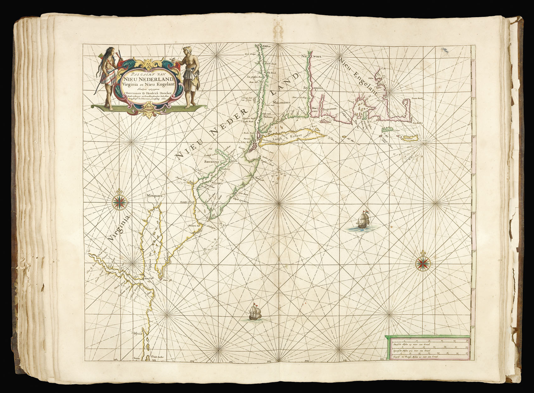
Koeman notes: "Doncker's charts were the most up-to-date in the second half of the seventeenth century. Although there is some similarity to those charts published by Van Loon, Goos, Lootsman, and Doncker, the latter's charts are original. More frequently than... [his] contemporaries, Hendrik Doncker corrected and improved his charts. He often replaced obsolete charts by new ones... This consciousness of the high demands of correctness is reflected by the development of Doncker's sea atlas". The charts of the Americas include the 'Pas caert van Nieu Nederland, Virginia en Nieu Engelant' - the third printed chart of the New Netherlands, and the 'Pascaart vertoonen de Zeecusten van Chili, Peru, Hispania Nova, Nova Grenada en California - orientated with east at the top and depicting California as an island on a larger scale than any earlier sea chart.
The list of charts in the atlas conforms to Koeman Don 9A, with the dedication and introduction taken from the 1660 edition but containing the additional charts up until 1665. Seven of the charts bear the date 1664, with a further two dated 1665.
The first edition of the 'Zee-Atlas' was published in 1659, and only one example of that edition is known, in the National Libary of Australia. Between then and 1669 the number of maps was extended from nineteen to fifty. In 1676 Doncker introduced the larger format 'De nieuwe groote vermeerderde Zeeatlas'. The atlas was re-issued until as late as the early 1700s when it was published by Doncker's son, also Hendrick, who continued the business following his father's death in 1699.
bibliography:
bibliography:
c.f. Koeman, Don 9a for one with a 1666 title page.