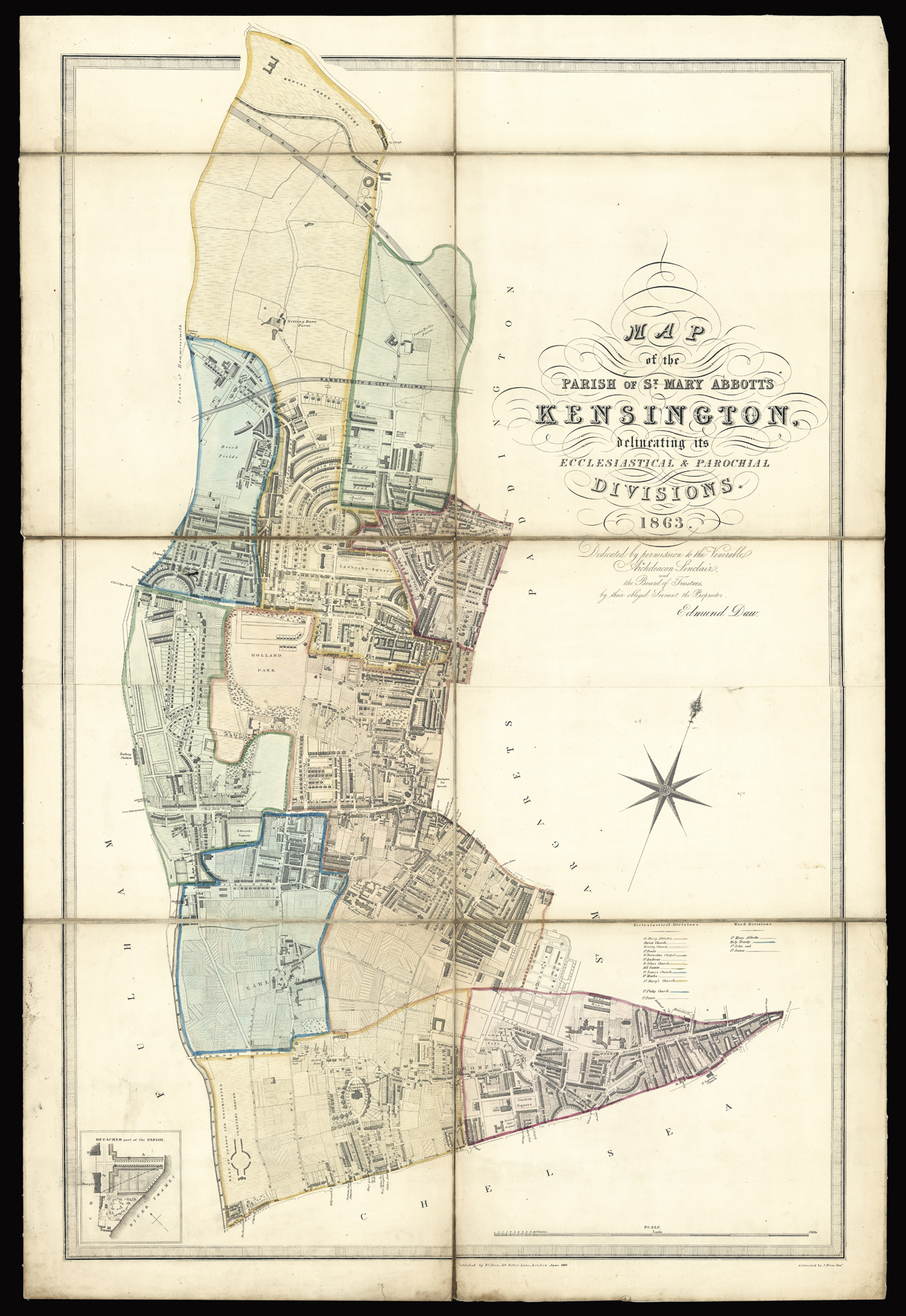
Map of the Parish of St. Mary Abbotts Kensington, delineating its Ecclesiastical & Parochial Divisions. 1863.
Dedicated by permission to the Venerable Archdeacon Sinclair, and the Board of Trustees, their obliged Servant the Proprietor Edmund Daw. Corrected by J Blore Esq.
Large engraved plan, fine original hand-colour, on two sheets, dissected and mounted on linen, list of Ecclesiastical and Ward Divisions, and inset of a detached part of the parish.
The plan stretches from north to south from Kensal Green Cemetery, to the Fulham Road, and west to east from the Royal Crescent on Holland Park Avenue to Sloane Street. The plan includes the areas of Holland Park, Earls Court, and the Brompton. Ecclesiastical and and ward divisions are marked and coloured. To the lower left is the detached part of the parish, depicting the Royal Hospital Gardens in Chelsea.
The plan shows in great detail the westward expansion of...
The plan stretches from north to south from Kensal Green Cemetery, to the Fulham Road, and west to east from the Royal Crescent on Holland Park Avenue to Sloane Street. The plan includes the areas of Holland Park, Earls Court, and the Brompton. Ecclesiastical and and ward divisions are marked and coloured. To the lower left is the detached part of the parish, depicting the Royal Hospital Gardens in Chelsea.
The plan shows in great detail the westward expansion of Victorian London. Between 1850 and 1880 Kensington was to undergo a complete transformation, from a rural landscape to an urban one. Estate development played an important role, which led to a greater architectural harmony as landowners frequently used the same architects and builders. They also co-operated in improving communications, in particular the laying out of roads. South Kensington, despite the speed of construction, was a high-class residential area composed mainly of large terraced houses of the 'premier type'. In North Kensington large terraced houses, garden squares and fine villas were built, especially in Notting Hill. Smaller speculative projects were the norm in Chelsea. In southern Kensington alone 1600 houses were built in 10 years. By the time of the present plan's publication the Borough accounted for ten percent of all buildings erected in London.
The plan proved so popular and the rate of expansion so quick that Edmund Daw, published editions in 1848, 1852, 1858 1863, and 1879.
The work is dedicated to Archdeacon John Sinclair (1797-1875), who was at the time Archdeacon of Middlesex, which makes up the Kensington episcopal area of the Diocese of London.
We are unable to trace any institutional example of this edition. The British Library holds an 1852 edition of the plan.
Scale: 11 inches to one statute mile
bibliography:
bibliography:
This edition not traced in the British Library but c.f. BL Cartographic Items Maps 4077.(3.) for 1852.