Sold by S. Harding on the Pavement in St Martin's Lane, and by W. H. Toms, Engraver in Union Court near Hatton Garden, Holborn,
1733 [but 1739].
Engraved map, on 20 printed mapsheets, 15 double-page maps and 5 single-page maps (the single-page maps comprise bird's eye views and harbour plans which appear on the right side of the map, from top to bottom, with 20 of the 22 views and plans appearing on these 5 sheets, the last 2 views appear on sheet 1, in the upper left corner of the map). Each of the maps is mounted on a guard.
Popple's 20 sheet Map of the British Empire in America is one of the two most important large format maps of North America published in the eighteenth century. Along with John Mitchell's Map of the British & French Dominions in North America... (1755), the map was a profound statement of England's designs for dominance of the North American continent; at a time when colonial control of North America was by no means certain.
Henry Popple worked with the Board of ...
Popple's 20 sheet Map of the British Empire in America is one of the two most important large format maps of North America published in the eighteenth century. Along with John Mitchell's Map of the British & French Dominions in North America... (1755), the map was a profound statement of England's designs for dominance of the North American continent; at a time when colonial control of North America was by no means certain.
Henry Popple worked with the Board of Trade & Plantations in 1727 during a period when boundary disputes among both the colonists and with the French began to accelerate the need for detailed maps. In 1730 the Board began requesting detailed maps of the entirety of the provinces and contiguous regions. Popple issued an announcement for his map in 1731, but did not complete work on his 20-sheet map until 1733. Despite his connection to the Board of Trade & Plantations, Popple's map was not a commercial success, and did not sell well until publication of the map was taken over by William Henry Toms and Samuel Harding in 1739. With the outbreak of the War of Jenkin's Ear, the map found its commercial moment and sales soared. In 1746, the rights to Popple's map were sold to Willdey and Austen, who published the map until Austen's death in 1750. As noted by Barbara McCorckle in 'America Emergent':
"Little is known of Henry Popple except that he came from a family whose members had served the Board of Trade and Plantations for three generations, a connection that must have been a factor in his undertaking the map, his only known cartographic work" (McCorkle 21.)
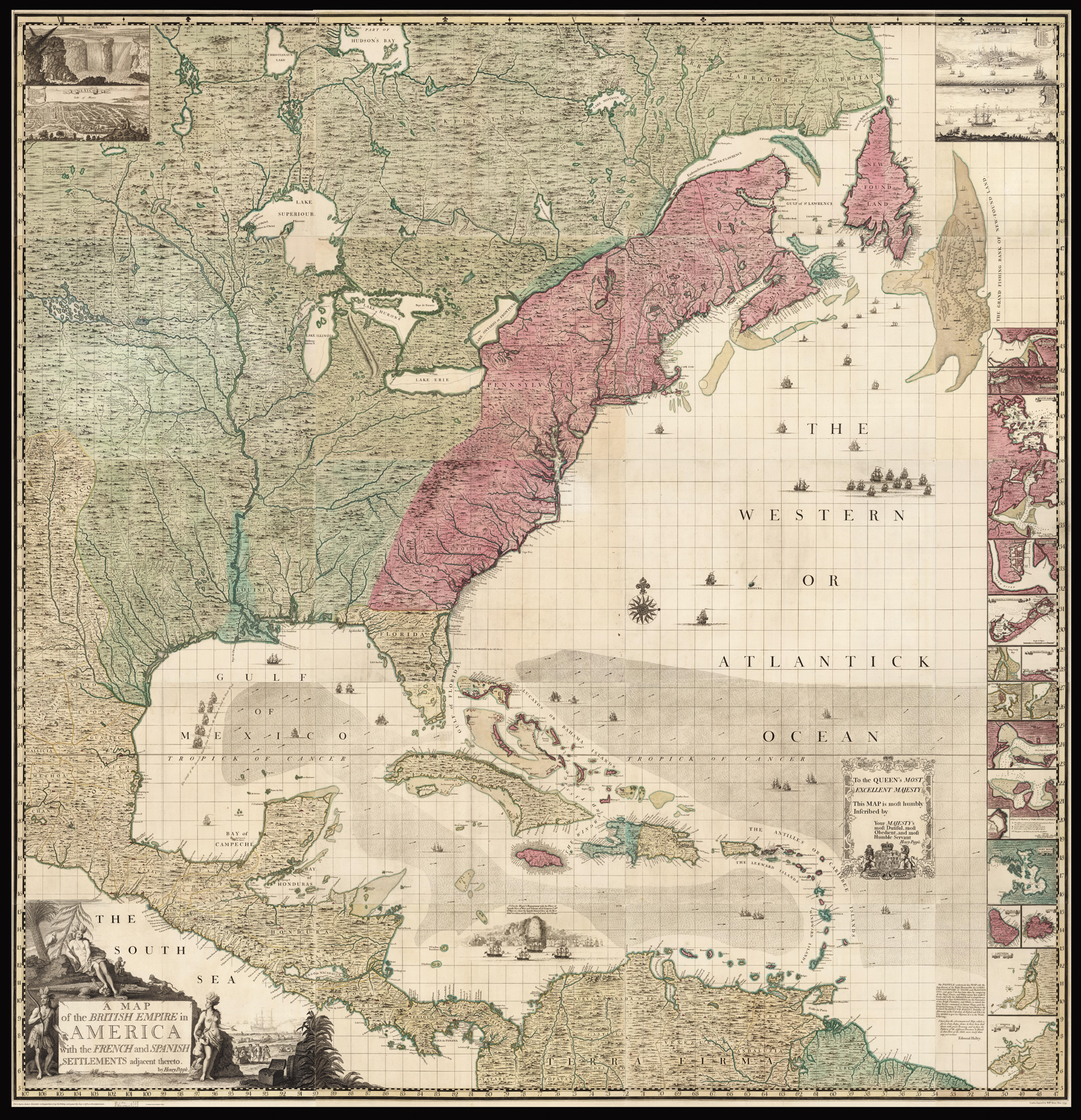
Popple's map is the first large scale printed map to show the thirteen colonies. The map is nearly 8 feet square when joined, and shows the extent of the British, French, and Spanish colonial possessions. The information on the map was based on Popple's work at the Board of Trade and Plantations in London. Popple's map was widely copied by other cartographers and remained the standard map of North America for several decades. The map was issued both as a wall map and as an Atlas, with the present example including advertising for the various formats in the lower margin of sheet 17, including pricing of the various formats.
Popple produced the map under the auspices of the Lord Commissioners of Trade and Plantations to help settle disputes arising from the rival expansion of English, Spanish and French colonies. At the time of its publication, "France claimed not only Canada, but also territories drained by the Mississippi and its tributaries - in practical terms, an area of half a continent" (Goss The Mapping Of North America p.122.).
Popple's map was also the first English map to name all the original thirteen colonies and one of the first maps to show Georgia. The new Colony of Georgia was chartered in London in July 1732, but developed only in early 1733, with the landing of James Edward Oglethorpe and his small party of 120 colonials. Oglethorpe returned to England in 1734 and met with the King on July 20, 1734, showing him "several charts and Curious Drawings relating to the new Settlement of Georgia". The same charts and maps must have been almost immediately made available to Popple by Oglethorpe, as Popple immediately incorporated this new information into a corrective paste-down mounted on Sheet 10 in State 3 of the map. The new information regarding Georgia was then engraved onto the map in State 4 published in late 1734. [Babinski, note 12, 13]. The new Colony of Georgia was considered by the British as an attempt to create an important protective buffer between the more densely populated English Colonies in the north and the Spanish in Florida.
Popple's map was intended among other things to provide a large format, up-to-date map of the region in order to better understand and demarcate the rival claims. On close examination, an engraved dashed line identifying the boundaries of the colonial powers can be seen. However, to facilitate a clearer visual depiction of these boundaries, Popple devised a colour scheme for depicting the claims of the various colonial powers. As noted by Babinski:
"The typical coloring [sic] of fully colored copies... is described best by a contemporary manuscript legend on the end-paper affixing the Key map to the binding in the King George III copy at the British Library: Green - Indian Countrys. Red - English. Yellow - Spanish. Blue - French. Purple - Dutch."
The careful demarcation of the disputed areas by color makes identification of whether a particular location was in one or another 'zone' a great deal easier. Thus the full original color examples are particularly important in facilitating the graphical depiction of the international land disputes of the time.
Popple's map was both a cartographic landmark and a visual icon among the social elite of the British Colonies. As noted by Bruckner in The Geographic Revolution in Early America:
"British Americans frequently imported imperial maps during the eighteenth century. Decorative wall maps showing British possessions in North America were favorite articles, purchased primarily by the colonial elite. Strategically displayed in formal settings of the home or provincial office, these maps painted bombastic scenes of territorial conquest and signified the range of the British Empire. For example, maps like Henry Popple's Map of the British Empire in America (1733) reached American audiences upon special orders by the Board of Trade and Plantations, and colonial politicians like Benjamin Franklin eagerly requested Popple's map for public display".
As noted by Babinski, Samuel Harding and William Henry Toms took over the proprietorship of the map from Henry Popple in August, 1739 and advertised it frequently in the newspapers, with their last advertisement in July 1745 [Babinski, Notes 4-8].
bibliography:
bibliography:
Babinski state 7; Babinski, M., 'Henry Popple's 1733' map (New Jersey, 1998); Brown, 'Early Maps of the Ohio Valley 14'; cf. Cumming, 'The Southeast in Early Maps', 216, 217; Pritchard, M., 'Degrees of Latitude', 24, state 4 (but with engraved number to sheet 1); McSherry Fowble, E., 'Two Centuries of Prints in America 1680-1880' (1987), 6, 7; cf. Goss, J. 'The Mapping of North America' (1990) 55 (key map only); Graff 3322; Howes P481, "b"; Lowery 337 & 338; McCorkle, 'America Emergent' 21; Phillips Maps p.569; Sabin 64140; Schwartz & Ehrenberg p.151; Streeter Sale 676; Stephenson & McKee Virginia in Maps, map II-18A-B.