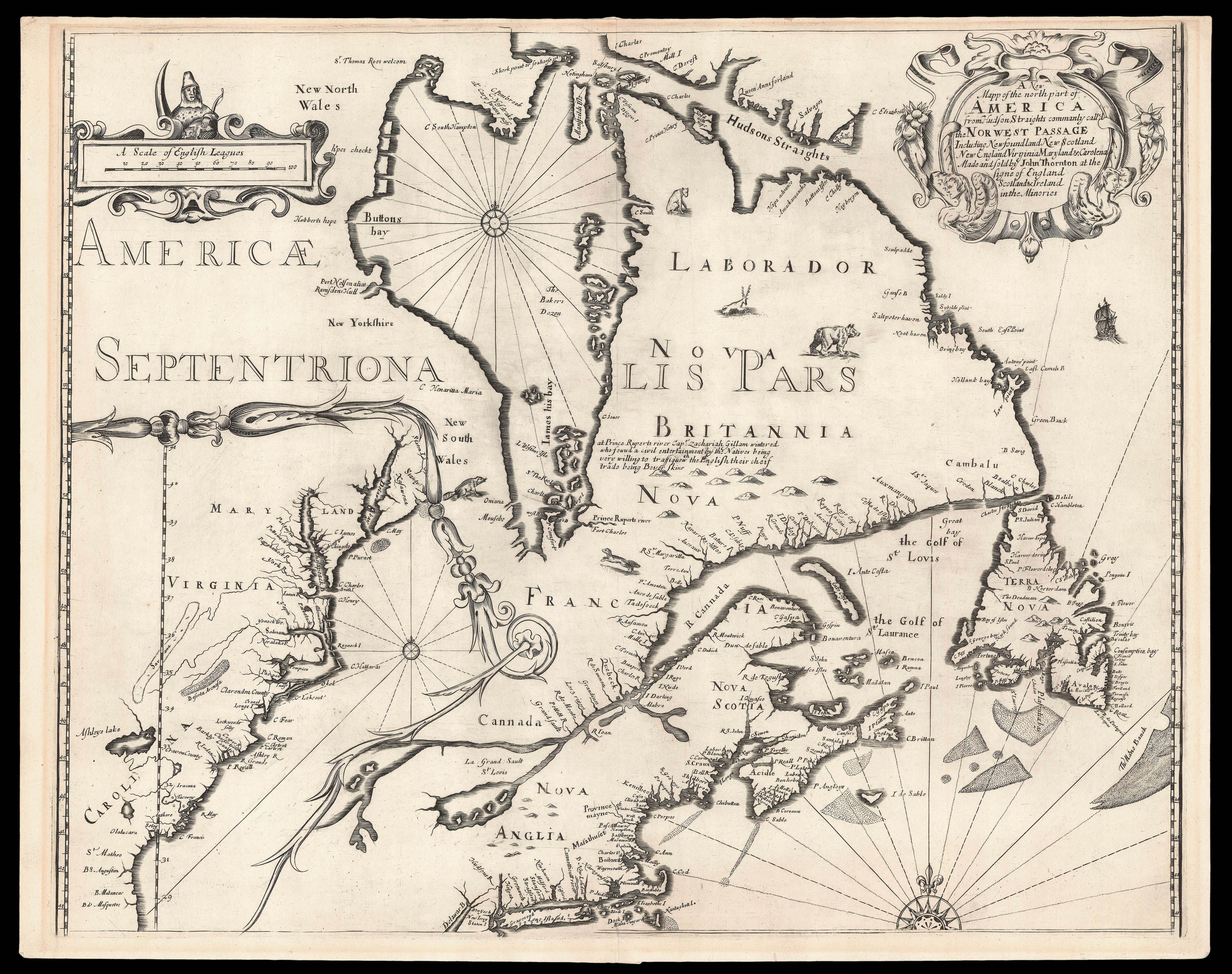
Separately issued, and exceptionally rare, this is Thornton's first published chart; the first printed map to show the activities of the Hudson's Bay Company; and the second printed map to show features of Lederer's discoveries.
"This map, formerly dated tentatively 'ca. 1680,' was advertised for sale in the London Gazette for 20-24 February 1673." (Cumming, The Southeast in Early Maps, 89). A superb map of New England, Hudson Bay, eastern Canada, with an inset o...
Separately issued, and exceptionally rare, this is Thornton's first published chart; the first printed map to show the activities of the Hudson's Bay Company; and the second printed map to show features of Lederer's discoveries.
"This map, formerly dated tentatively 'ca. 1680,' was advertised for sale in the London Gazette for 20-24 February 1673." (Cumming, The Southeast in Early Maps, 89). A superb map of New England, Hudson Bay, eastern Canada, with an inset of the American southeast and mid-Atlantic coastline within a fine asymmetrical rococo cartouche lower left, and the title within another upper right, decorated with native animals, a galleon and three compass roses. The inset of the southern colonies is not some "casual insertion, some effort has been put into making the map as up to date as possible... The results of Lederer's recent voyages published in 1672 are incorporated here with the inclusion of Savana and Deserta Arenosa" (Burden 432).
John Thornton was one of the leading English chart-makers, active between 1667 and 1708. He was apprenticed to John Burston in the Draper's Company in 1656; at the time, and despite the name, the Draper's Company was the epicentre for the leading makers of manuscript charts in England, with Burston a prominent figure in the so called "Thames school", and Thornton emerges as a skilled practitioner both as a maker, and possibly as an engraver. He described himself as Hydrographer to the East India Company and Hydrographer to the Hudson Bay Company, although he is not recorded as such in the records of either company.
He was the first member of the "school" to make the transition from manuscript to printed charts, publishing three charts relating to the Americas or Atlantic in 1673, one of them being the present chart. Thornton would go on to publish some of the most important maps of the English American colonies of the period: with Robert Greene 'A Mapp of Virginia Mary-Land, New Jarsey, New York, & New England' (1679); and with John Seller 'A Map of some of the South and Eastbounds of Pennsylvania' (1681). He collaborated frequently with Thomas Holme, producing 'A Portraiture of the City of Philadelphia' (1683), 'A New Map of the English Empire, in the Continent of America' (1685) and 'A Map of the Province of Pennsilvania' (1687). Above 40 manuscript charts and somewhat over 100 printed charts and maps by Thornton survive, this corpus earning him the accolade "the most competent and distinguished chart-maker in England" (William Ravenhill).
The present map centres on the French controlled regions of North America, especially surrounding Hudson's Bay, and it has been suggested that the purpose of publication was due to the newly formed Hudson Bay Company. This supposition is strengthened by an advert placed in the London Gazette for 20-24 February 1673 stating 'A new Map of the North part of America from Hudson Streights, commonly called the Norwest passage, unto Prince Ruperts River...'. Indeed, it is the earliest map to record the company's activities.
"Pierre Esprit Radisson and his brother-in-law, Médard Chouart, Sieur des Groseilliers discovered the rich fur-trading region surrounding Lake Superior in 1659. Because they traded illegally and did not share their profits with the French government their huge cargo of furs was seized. Transferring their allegiance to the English they encouraged trading in the region. In 1668 thirteen merchant adventurers sent the 'Nonsuch' under the command of Zachariah Gilliam to the region of Hudson Bay to investigate the fur-trading abilities of the region. It was perceived that the southerly reach of James Bay would go as far as the rich fur-trading grounds that the French enjoyed. A legend to the east of James Bay states 'at Prince Ruperts River Capt. Zachariah Gillam wintered who found a civil entertainment by the Natives being very willing to Traffique with the English their cheif trade being Bever skins'. Both 'Prince Ruperts River' and 'Fort Charles' are identified".
"Following the return of the Nonsuch in 1669 the judgements of Radisson and Groseilliers were vindicated. The Hudson Bay Company was formally chartered in 1670 by Charles II, although it had been trading as an informal group of men for some years already. Probably because of the hostility of the region's climate and the nature of the way in which it was to finance itself, i.e. fur-trading, it was decided that trade and not colonisation would best suit the company. Its domain covered all the lands draining into Hudson's Bay, around 1.4 million square miles, or one third of present-day Canada. The region was named Prince Rupert's Land in honour of Charles II's cousin Prince Rupert, the first governor of the company. Hudson Bay's proximity to the English colonies in New England is nicely displayed. The Province of mayne is identified for the first time and an inset of the southern colonies is also included" (Burden).
"The inset of the southern colonies records Lederer's recent voyages in Carolina, published in 1672. John Lederer, a German explorer and physician, had been commissioned by the then Governor of Virginia, Lord Berkley to explore the interior in order to ascertain the possible route to the Pacific coast. Thornton includes Lederer's 'Savana' and 'Deserta Arenosa', although he would appear to have used other sources as well. Most notably John Ogilby's map 'A New Discription of Carolina', also known as the First Lords Proprietors map (the Lords Proprietors being the governors of the province of Carolina) from which Thornton took the name 'Ashleys lake' for the inland lake in the south; Lederer had called it the 'Lake of Ushery'. "This… helps us to place a much more accurate date on the publication of that map as it is unlikely that Ogilby would have utilised the Thornton. Ogilby drew directly upon the Lords Proprietors who helped considerably in its production" (Burden).
Burden records five institutional examples: National Archives of Canada, the Clements Library, the John Carter Brown Library, the Royal Geographical Society, London.
bibliography:
bibliography:
Black (1975) no. 5; Burden II 432; Cumming & de Vorsey (1998) nos. 65 & 89; Kershaw (1993-98) I no. 216; McCorkle (2001) no. 673.4; Smith (1978); Tyacke (1978) no. 22; Verner (1975).
provenance:
provenance:
Provenance: 1. Private American Collection. 2. Private English Collection acquired 2004.