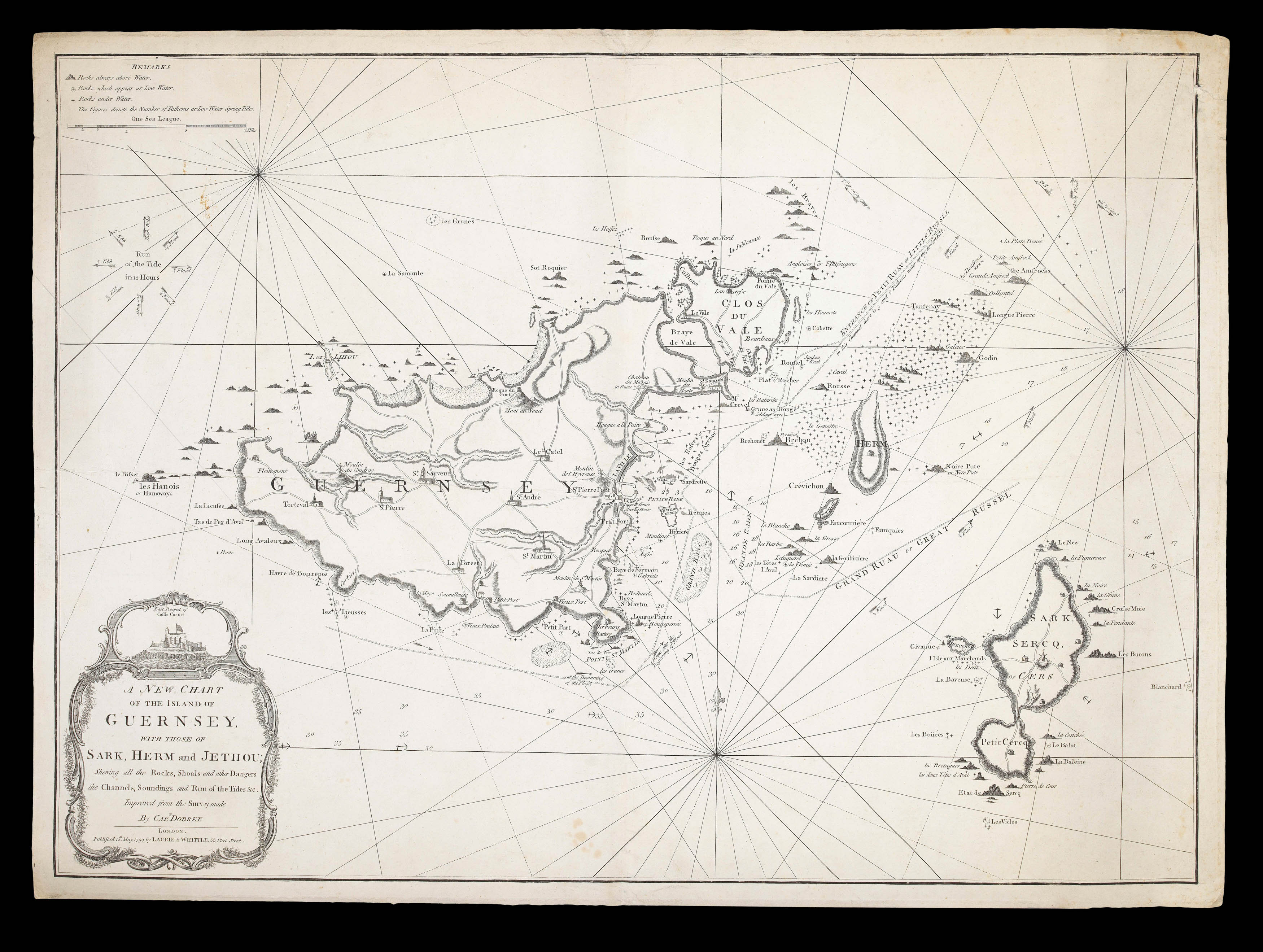
with those of Sark, Herm and Jethou; shewing all the Rocks, Shoals, and other Dangers; the Channels, Soundings and Run of the Tides &c. Improved from the survey made by Capt. Dobree.
The most detailed chart of Guernsey's waters published in the eighteenth century.
On 3rd October 1744 HMS Victory was wrecked with the loss of her entire crew, 100 bronze cannon and gold bullion. For over 260 years she was believed to have been wrecked during the night on Black Rock just off the Casquets (though the wreck was eventually located in 2009 some 60 miles away from the location), with all hands lost. As a result of this enormous loss, Nicholas Dobrée,...
The most detailed chart of Guernsey's waters published in the eighteenth century.
On 3rd October 1744 HMS Victory was wrecked with the loss of her entire crew, 100 bronze cannon and gold bullion. For over 260 years she was believed to have been wrecked during the night on Black Rock just off the Casquets (though the wreck was eventually located in 2009 some 60 miles away from the location), with all hands lost. As a result of this enormous loss, Nicholas Dobrée, at that time the local naval agent, was commissioned by the Lord High Admiral of Great Britain to produce a set of accurate sea charts detailing the waters around the the islands.
Dobree set about his surveying with great haste, and by 1746 he had produced three charts of the Channel Islands: 'A General Chart of the Islands of Guernesy and Jersey...'; 'An accuarte chart of the Island of Alderney and Burhou'; and the present chart 'A New and Exact Chart of the Islands of Guernsey, Sercq, Herm & Jethou'.
In the sailing directions 'Observations on the charts of the islands of Guernsey, Alderney', that accompanied the charts, Dodree provides details on how the charts were to be used:
"The general chart of the Islands is only useful to show the bearing and the distance of each of these from one another, and what course to keep to approach them; so that when you come near Alderney or Guernsey, make use of the particular Charts of those Islands."
And how the survey was undertaken:
"He has been on the rocks and dangerous places, have taken all the soundings, and examined the ebbing's and flowing's of the tide, in order to place them all in the most exact manner; and that strangers might the more easily come to, or go from Guernsey or Alderney, he has drawn the following instructions, by the help of which they may come to these Islands without the least fear".
The chart is superbly detailed with soundings, hazards including rocks, reefs and sand banks clearly marked; safe anchorages are also shown as are the safe approaches to Saint Peter Port. To the land are marked the principal towns, villages, and windmills. So accurate was it that it would become the standard work for well into the nineteenth century.
The present chart, engraved on a new plate, has been updated from Dobree's original, with the addition of roads to the islands, the movement of the title to the lower left, with the vignette view of Castle Cornet now above the title.
The chart is particularly rare to the market; we are unable to trace any examples appearing at auction since the Second World War.