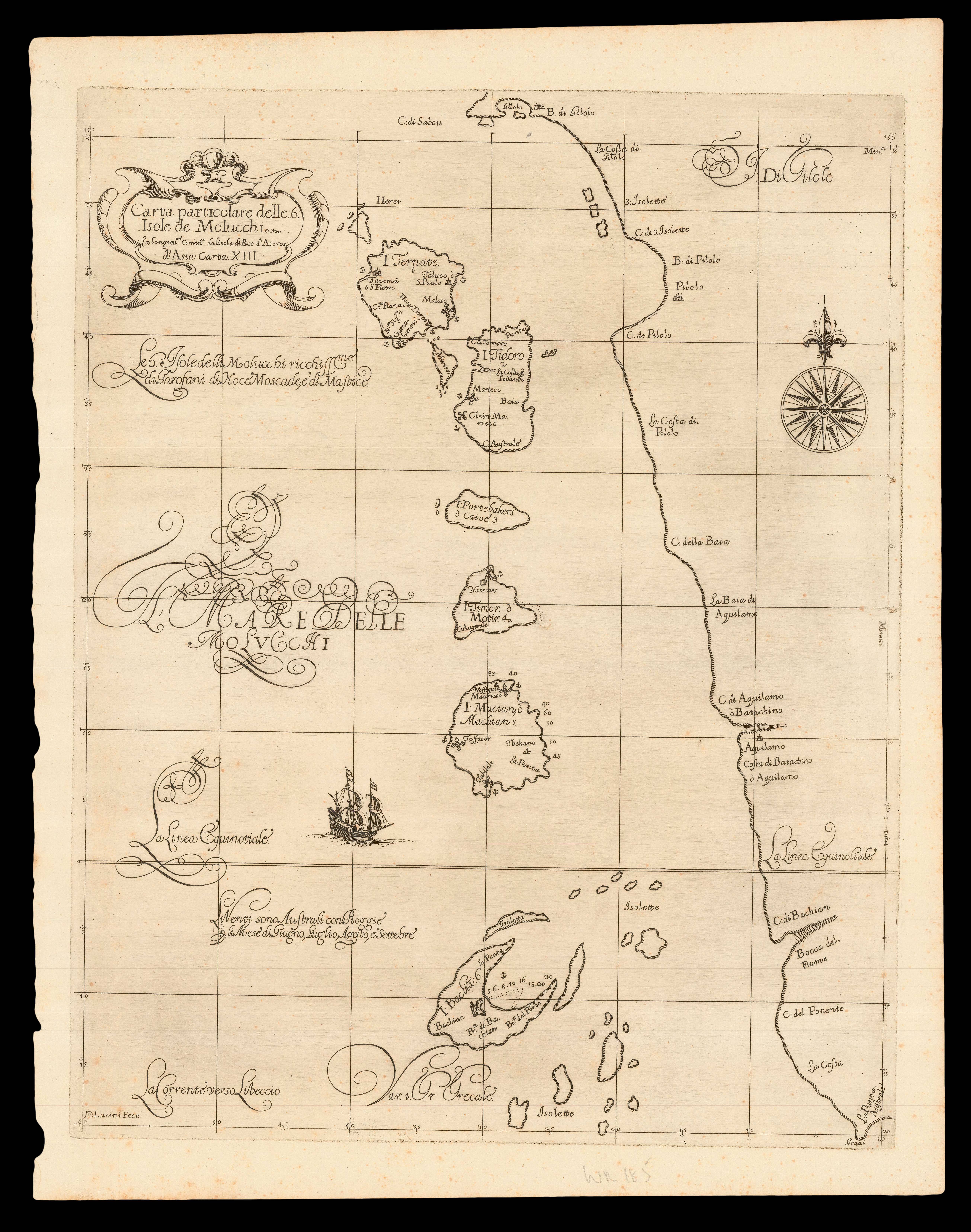
Chart of the northern Maluku Islands, historically known as the Moluccas, or Spice Islands, showing coastal towns, and harbours. A very early chart of the area, by an Englishman, following that of Willem Blaeu's 'Moluccæ insulæ celeberrimæ' (1638), which was the first large-scale printed map of the islands. The west coast of the largest island in the group, Gilolo, present-day Halmahera, appears in the east. There are, in fact, hundreds of islands in the group, but only a v...
Chart of the northern Maluku Islands, historically known as the Moluccas, or Spice Islands, showing coastal towns, and harbours. A very early chart of the area, by an Englishman, following that of Willem Blaeu's 'Moluccæ insulæ celeberrimæ' (1638), which was the first large-scale printed map of the islands. The west coast of the largest island in the group, Gilolo, present-day Halmahera, appears in the east. There are, in fact, hundreds of islands in the group, but only a very select group feature in the more than two-hundred years of colonial strife that was the European spice trade. Until the eighteenth century, these rain-forested islands were the only obtainable source of cloves, nutmeg, and mace.
Arab traders "introduced cloves to Europeans around the fourth century but sought to keep their sources secret. Their monopoly was broken by the Portuguese after Vasco da Gama's voyage to India around the Cape of Good Hope in 1497. The Portuguese strengthened their stranglehold on the spice trade during the sixteenth century, when they found the central locus of the spices to be these islands. One of the native traditions was to plant a clove tree when a child was born, linking the child symbolically to the life of the tree. When the Dutch took over control of the Moluccas in the seventeenth century, they eradicated the clove trees from all the islands except Amboina (and a few adjacent islands) in order to enforce the spice's scarcity, keeping prices high. As a result, cloves were worth more than their weight in gold. But, as one might expect, the Dutch tactic also instilled hatred and fomented rebellion among the islanders. Gradually, the spice was cultivated in other places of the world, like Brazil, the West Indies, and Zanzibar, reducing prices and making the commodity more available" (Princeton University Library online). The British gained a foothold twice in the islands, but they became official Dutch colonies, once again, during the first quarter of the nineteenth century.
From the first edition of 'Dell'arcano del mare, di D. Ruberto Dudleo Ducadi Nortumbria e conte di vvarvich, libri sei...'.
The 'Arcano del Mare', one the "greatest atlases of the world" (Wardington), was first published in 1646 when its author, Robert Dudley, was 73, it was not only the first sea atlas of the world, but also the first to use Mercator's projection; the earliest to show magnetic deviation; the first to show currents and prevailing winds; the first to expound the advantages of 'Great Circle Sailing' – the shortest distance between two points on a globe; and "perhaps less importantly the first sea-atlas to be compiled by an Englishman, albeit abroad in Italy" (Wardington).
Robert Dudley (1574-1649) was the son of the Earl of Leicester (the one time favourite of Elizabeth I) and Lady Douglas Sheffield, the widow of Lord Sheffield. Although born out of wedlock, Robert received the education and privileges of a Tudor nobleman. He seems to have been interested in naval matters from an early age, and in 1594, at the age of 21, he led an expedition to the Orinoco River and Guiana. He would later, like all good Tudor seamen, sack Cadiz, an achievement for which he was knighted.
His success upon the high-seas was not matched, unfortunately, by his luck at court, and at the beginning of the seventeenth century he was forced to flee, along with his cousin Elizabeth Southwell, to Europe. Eventually, in 1606, he ended up in Leghorn, Italy, which he set about turning into a great international naval and commercial seaport, in the service of Ferdinand I. Dudley, successful at last, married his cousin, converted to Catholicism, helped Ferdinand wage war against the Mediterranean pirates, by designing and building a new fleet of fighting ships for the Italian navy, served as Grand Chamberlain to three Grand-Duchesses of Tuscany in succession: Maria Maddelena, widow of Cosimo II; then Christina of Lorraine, widow of Ferdinand I; then to Vittoria della Rovere, Princess of Urbino, and wife of Ferdinand II, who created Dudley Duke of Northumberland.