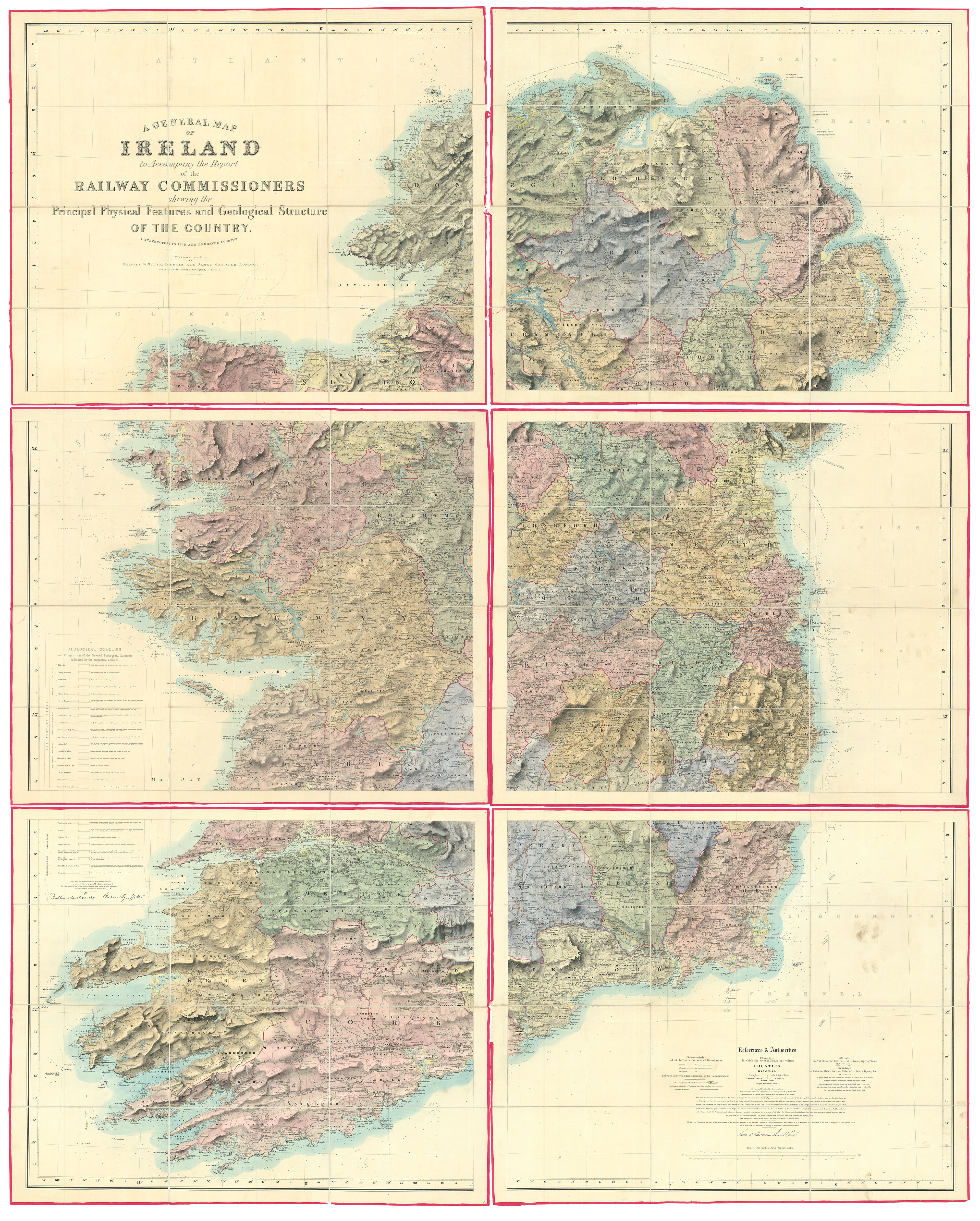
Griffith's map not only represents the most accurate map of Ireland published to date, but is also the first geological map of the country, putting the great work on a par with the likes of William Smith's geological map of England (1815), and John Macolloch's map of Scotland (1836).
Richard Griffith (1784-1878), surveyor and geologist, began his great endeavour in 1810. By the spring of 1814, he had outlined much of the country's geology on a copy of Alexande...
Griffith's map not only represents the most accurate map of Ireland published to date, but is also the first geological map of the country, putting the great work on a par with the likes of William Smith's geological map of England (1815), and John Macolloch's map of Scotland (1836).
Richard Griffith (1784-1878), surveyor and geologist, began his great endeavour in 1810. By the spring of 1814, he had outlined much of the country's geology on a copy of Alexander Taylor's 'New Map of Ireland' (1793), which he used in lectures that he gave to the Dublin Society, whilst he was employed as their mining engineer, between 1812 and 1829. In 1834, the map was copied (with the permission of Griffith) by the newly formed Geological Society of Dublin. Later versions of the map would be displayed at learned societies in Liverpool and Newcastle.
In 1838, Griffith published a small-scale geological map to accompany the Railway Commissioners report. The following year, again under the aegis of the Railway Commissioners, Griffith published his great work, on the much larger scale of 1/4 inch to 1 statute mile. The base-map, on six sheets, was compiled by Lieutenant Thomas Aiskew Larcom (1801-1879) of the Irish Ordnance Survey, who along with Thomas Colby had begun a detailed survey of the country in 1828, with Griffith adding the geological information and tables. Griffith then coloured two master versions of the map, which would be used by the publishers Hodges and Smith (in London), and James Gardner (in Dublin) as templates. These Griffith would regularly update when new information became available.
The map was hugely successful, with 2,412 copies selling in the first year alone. The reason for this success was not only down to a clamouring for geological information, but as the first scientifically accurate map of the country, it fulfilled numerous administrative and governmental needs. In fact, it is most likely that only a small fraction of the maps were ever coloured geologically. So popular would the map be, that it would continue to be sold by the Ordnance Survey until the Second World War.
The present example of the map is a particularly early state with:
a) the boxes in the strata key measuring (4 by 18mm);
b) 'Silurian' in the key misprinted 'Silurean';
c) the last word in the 'Silurean System' key reading 'shale': this would later be corrected to 'slate'.
These 'errors' are characteristic of maps produced in the first month of printing, i.e. late May to late June 1839. Later examples would correct the spelling and enlarge the boxes.
The fact that the map is coloured by country boundaries and bears an ownership inscription to the chemise ("Sent to me from London by Mr Drummond Under Secretary, July 1840"), suggests that it was used by someone high-up in the British administration in Dublin, though unfortunately the ownership signature has been erased.
Rarity
Although the map is not uncommon institutionally, we are unaware of another first edition, first state appearing at auction since the Second World War.