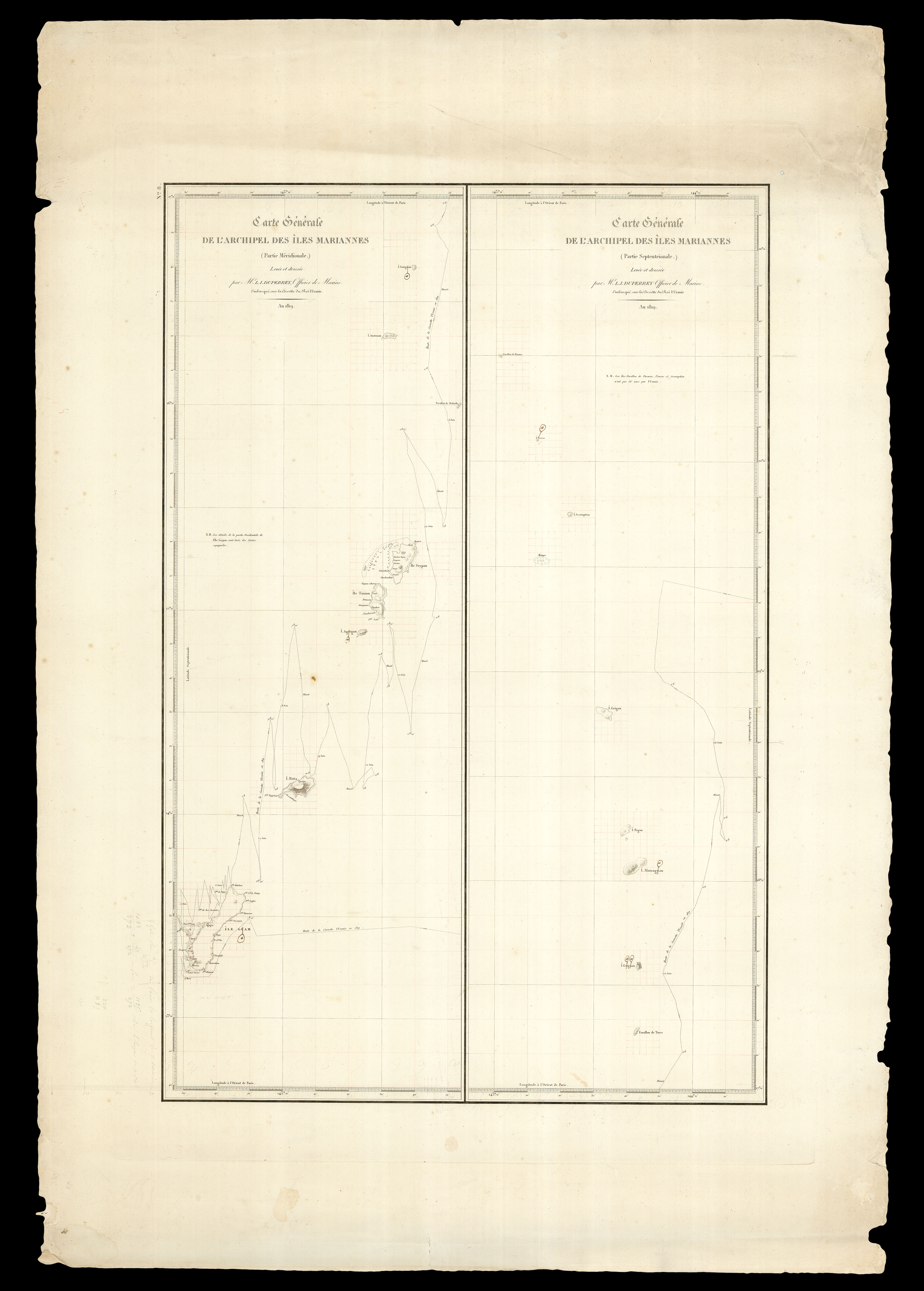
A fine separately issued example of this important chart, showing the route of 'l'Uranie' through the Marianas Islands in 1819, printed on "Depot de la Marine" paper, and annotated by Louis Freycinet in his familiar and distinctive style. Freycinet has added gridlines around most of the major landfalls on the map, a technique he used for added accuracy in the transfer of information and for further calculations. In the bottom left, adjacent to the island of Guam (the most s...
A fine separately issued example of this important chart, showing the route of 'l'Uranie' through the Marianas Islands in 1819, printed on "Depot de la Marine" paper, and annotated by Louis Freycinet in his familiar and distinctive style. Freycinet has added gridlines around most of the major landfalls on the map, a technique he used for added accuracy in the transfer of information and for further calculations. In the bottom left, adjacent to the island of Guam (the most significant island on the map and a major port of call for the Freycinet expedition), Freycinet has made some pencil calculations and remarks relating to the size of the island's landmass. Lastly, there is a series of repeated corrections turning the letter "u" into "w", in reference to the islands of Sariguan, Uracas, Aguigan, Guam, Almaguam and Guguan.
In a memorandum on Duperrey's career, 'Notice sur les Travaux de Mr. L.I. Duperrey' (1842), Louis Freycinet singled out Duperrey's work on Guam, in the southwestern corner of the archipelago, for particular notice as regards its accuracy and significance, noting that the mapping of the region was done in unusually favourable conditions. Guam was one of Freycinet's key locations for determining the magnetism of the earth, and hence its sphericity.
Also issued as plate no. 8 from the Atlas volume, 'Navigation et Hydrographie', for the official account of his 'Voyage autour du monde: entrepris par ordre du Roi... execute sur les corvettes de S.M. l'Uranie et la Physicienne, pendant les annees 1817, 1818, 1819 et 1820' (1826).
In 1817, Louis Freycinet took command of the corvette 'L'Uranie', "formerly 'La Ciotat', with a complement of 120 men, and 23 officers, including a priest and an artist, Jacques Arago, who also kept an account of the voyage. Of importance, and in contrast to the preceding D'Entrecasteaux and Baudin voyages, where dissension and conflict between the scientists and naval staff was evident, there was to be only one ship and the vast majority of its complement were to be naval personnel. The mission nonetheless grew into a full scientific enterprise part-charged with the investigation of the shape of the earth, terrestrial magnetism, meteorology, and natural science. Further adding to the comprehensive nature of the venture, the expedition report was to be presented under many varied headings, viz. geography, history, observations of the people, government, commerce, primary produce, industries and art. With 596 sub-classes listed under these headings according to Leslie Marchant in his seminal work, France Australe, it made the Uranie voyage 'one of the most significant anthropological expeditions conducted by the French'" (McCarthy, WA Museum's "Journeys of Enlightenment" exhibition 2008).
In order to help determine the sphericity of the earth, Freycinet and his crew measured the magnetism of the earth at three key different locations: Mauritius, Guam (between the Philippines and the Marshall Islands), and Maui in the Hawaiian Islands. He then calculated the degree of flattening for each hemisphere, and at the equator, and concluded that the earth was basically round.
bibliography:
bibliography:
Hill, 'Pacific', 649.
provenance:
provenance:
Provenance 1. Extensively annotated by Louis Claude de Saulces de Freycinet; 2. Freycinet family archives