The November 4th issue of the 'Wellesley College News', 1926, proudly announces the publication of Mitchell's map: "Alumna places college 'on the map' by including features dear to Wellesley and Dana".
One of the earliest full-colour pictorial maps, and particularly of the new subgenre of collegiate pictorial maps, published in the United States. Mitchell's map was originally the brainchild of Miss Helen F. McMillin, editor of the Wellesley 'Alumnae Magazine', a...
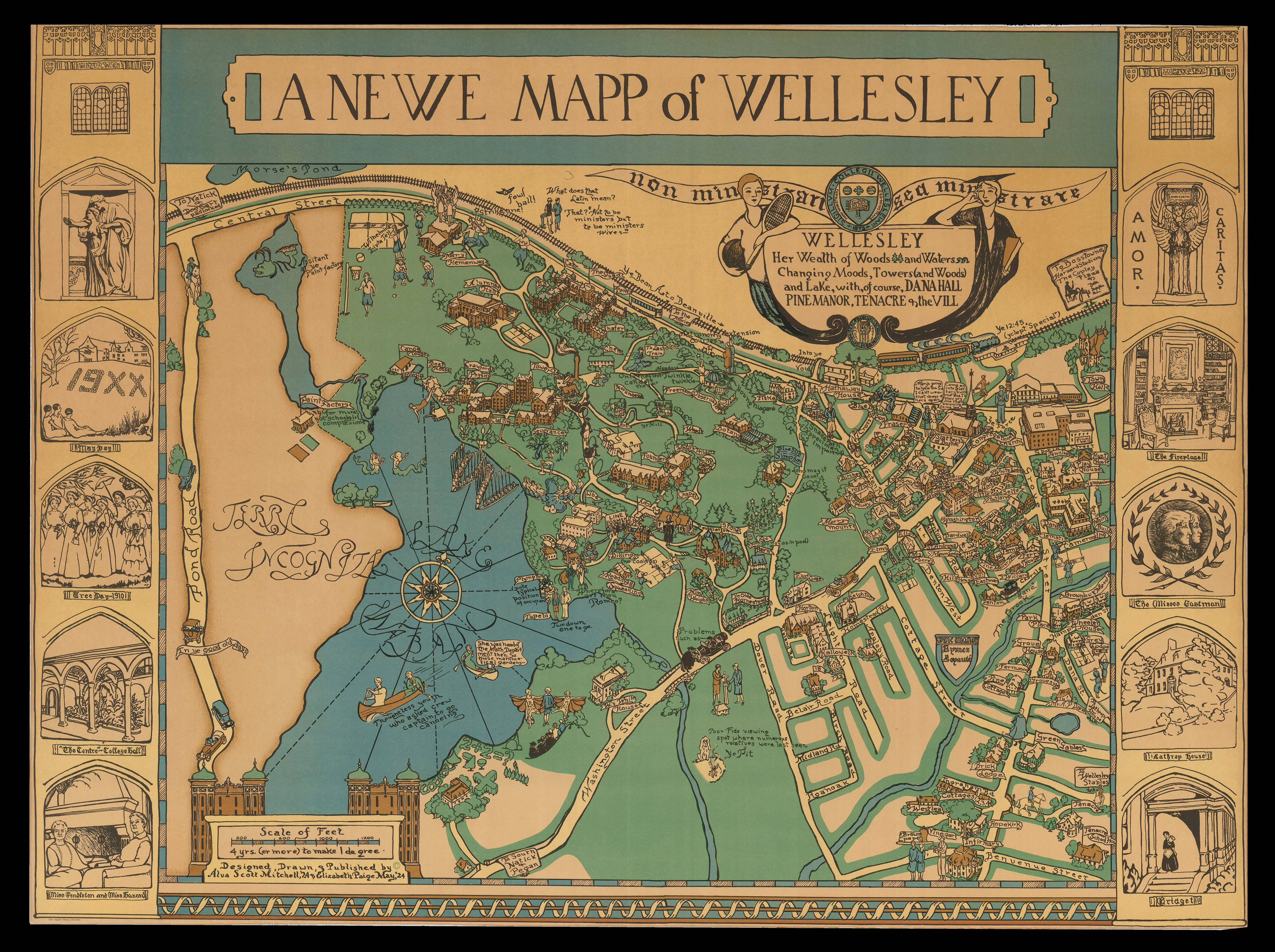
The November 4th issue of the 'Wellesley College News', 1926, proudly announces the publication of Mitchell's map: "Alumna places college 'on the map' by including features dear to Wellesley and Dana".
One of the earliest full-colour pictorial maps, and particularly of the new subgenre of collegiate pictorial maps, published in the United States. Mitchell's map was originally the brainchild of Miss Helen F. McMillin, editor of the Wellesley 'Alumnae Magazine', and Miss Elizabeth Shurtleff, who had published their own pictorial 'Map of the State of New Hampshire' in June, 1926. Too busy with other projects – i.e. their own map – to "carry out their idea themselves, they passed it on to Mrs. Elizabeth Paige May, '24, with the suggestion that she ask Mrs. Mitchell to undertake the map. And so 'A Newe Mapp of Wellesley' has made its appearance" ('Wellesley College News'). The article continues to say that Mitchell published the map herself, and that "Five thousand copies have been printed in the first edition". However, the scarcity of the map – with only three institutional examples, and only one other in the market, known – would seem to contradict this last statement.
The map is a "delightful creation in five colors. It includes not only the college, but also Dana Hall and the village. The buildings are in natural color, the majority being red. On campus they stand out against a green background. The village and Dana are marked off from the college grounds by being bordered with green, rather than being in the solid color. The 'Terra Incognita' across the lake is red, and the territory beyond the railroad is yellow. The map and the pictures at the sides are bordered with the same yellow. The lake and ponds are, of course, blue, as are also the dresses of the Dana girls. The black of the printing and the senior caps and gown makes the fifth color. All the colors are in soft tones, giving somewhat the mellow appearance of the old maps.
The seals of Wellesley and Dana Hall and the College motto form part of the cartouche in which is inscribed the full title of the map. The cartouche and the sketches on either side of the map are green colored. On the right of the map are five pictures pertaining to Dana Hall: the bronze which was given to Miss Cook, the head of the school, by St. Gaudens; the fireplace in the main building; the plaque by Taylor of the founders of Dana Hall; Lathrop House; and Bridget, who every evening rings the dinner bell on the porch of the main building. Mrs. Mitchell was greatly aided in her work on Dana Hall, Pine Manor, and Tenacre by Miss Hetty S. Wheeler, Miss Cook, and Miss Lathrop. The Wellesley pictures on the left of the map include the Alice Freeman Palmer Memorial, May Day numerals on Tower Court Hill, Tree Day in 1910. 'The Centre' of old College Hall, and a sketch of Miss Pendleton and Miss Hazard. Mrs. Mitchell has done a very complete piece of work in her map. All the traditional Wellesley days are included: the seniors are rolling their hoops down Tower Hill; Tree Day dancers grace the Presidents lawn; the crews have formed a W on the lake. Behind each society house there is a drawing of its pin. The map is more than up-to-date, for Mrs. Mitchell has put in Severance Hall and the new Botany building as completed" (Wellesley College News).
Mitchell commissioned The Tudor Press of Boston to print her map. Founded by Ralph Harland Wilbur (b1875) in about 1910, with the help of his sons, Harland, Alvra, and Wesley, the firm specialized in offset lithographic printing. They printed a number of pictorial maps, included several of those by Shurtleff. In 1940, they ran the first four-colour offset press in Boston. After WWII, they were commissioned by the Bureau of Printing and Engraving to print military currency for occupying US forces overseas, particularly those in Germany. The company, which appears to be still family owned, changed its name to Graphic Litho in 1967.
Born Alva Bennett Scott (1902-1993), she married twice, first to James Armistead Mitchell in 1925, and then to Mason Garfield in 1942. Her subsequent maps, referred to as "Scott-Maps", are a series of colourful and distinctive pictorial maps of New England and New Hampshire, including maps of Harvard, Concord, Boston and Salem. The maps owe as much to their sixteenth and seventeenth century forbears as they do to the early twentieth century maps of Max Gill.
Rare. Only two institutional examples found: an uncoloured, ?proof, example at the LoC; and the Boston Athenaeum. One other example known in commerce.
bibliography:
bibliography:
Barron, 'Scott Maps: The life & work of Alva Scott Garfield [1902-1993], 20th Century female cartographer', 2017; Hornsby, 'Picturing America', page 22, plate 75