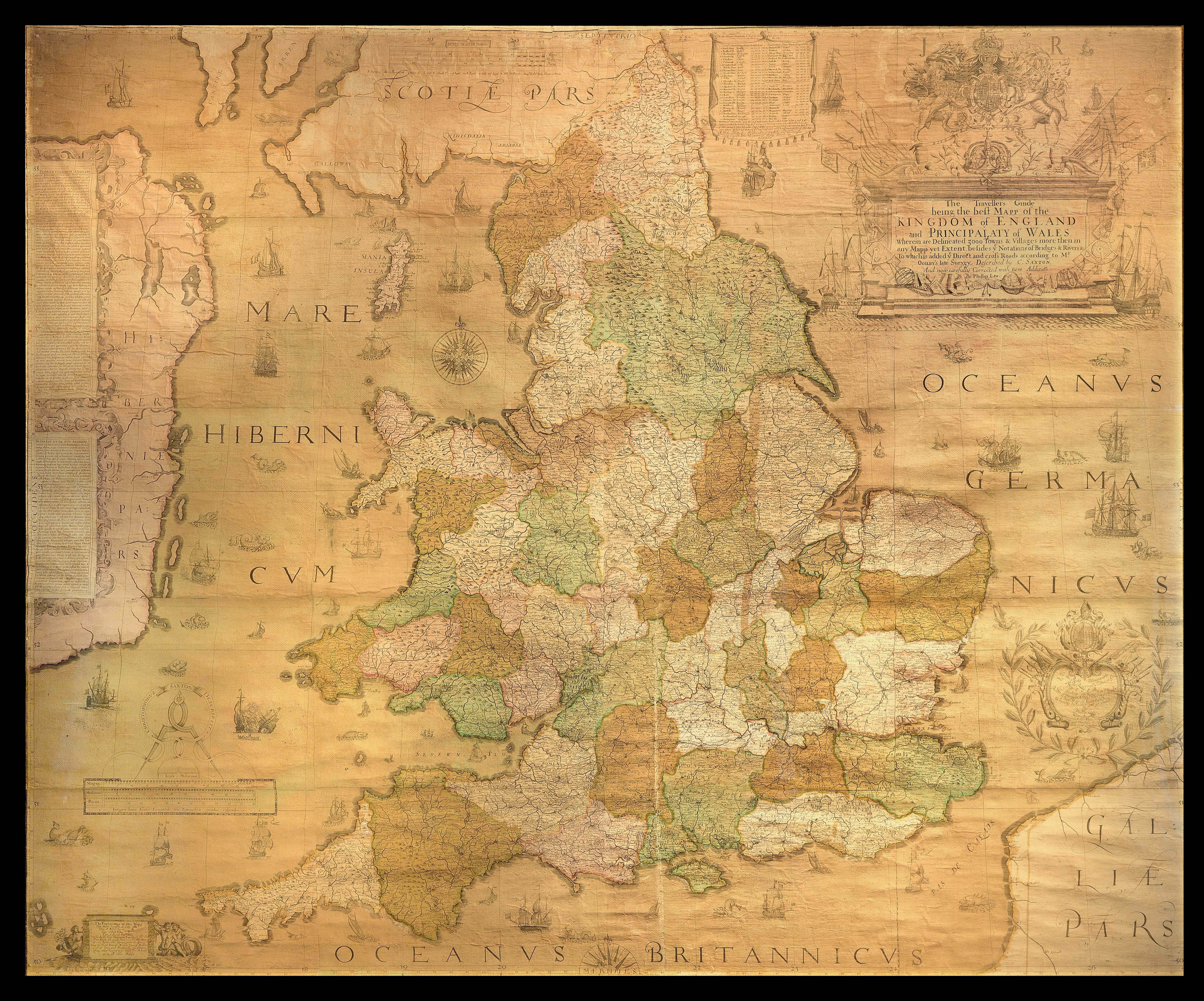
The Travellers Guide being the best Mapp of the Kingdom of England and Principality of Wales
Wherein are Delineated 3000 Towns & Villages more than in any Mapp yet Extent besides ye Notations of Bridges & Rivers &c. To which is added ye Direct and cross Roads according to Mr Ogilby's late Survey. Described by C. Saxton And now carefully Corrected with New Additions by Phillip Lea.
Christopher Saxton's wall map is a result of the first survey of the whole of England and Wales, and is the first map of those countries to give all the place names in English. Saxton has been dubbed "the father of English cartography" (Skelton).
The idea of making a survey of the kingdom and its parts in a consistent format developed in the mid sixteenth century. Although the first English map of Britain, by Matthew Paris, had appeared in about 1250, it was not ...
Christopher Saxton's wall map is a result of the first survey of the whole of England and Wales, and is the first map of those countries to give all the place names in English. Saxton has been dubbed "the father of English cartography" (Skelton).
The idea of making a survey of the kingdom and its parts in a consistent format developed in the mid sixteenth century. Although the first English map of Britain, by Matthew Paris, had appeared in about 1250, it was not until the mid fifteenth century that the principles of mapping were fully understood. These techniques emerged, in part, as a result of the practical needs of military engineers: military surveyors were well able to draft plans and topographical maps to scale by the 1540s. Estate surveys also became increasingly popular, as the advent of enclosures necessitated the definition of land boundaries. Thus, a large number of treatises on surveying and the use of the cross-staff appeared. Such interest led to the construction of increasingly sophisticated surveying instruments, resulting in a new accuracy in mapping.
Saxton's wall map dates from 1583, and was published separately from his atlas of 1579. Only two copies of the first state of the map are known to exist: one in Birmingham Public Library, printed on paper with watermarks consistent with the date on the map; the second example is bound in atlas form in the British Library and is probably a reprint from the original plates by William Web, dating from c.1642. "After the Restoration, Saxton's map was reissued on several occasions by publishers who made considerable alterations to the plates" (Shirley). Of these, only the second state, published by Cade and Morgan in 1678, is known to have been issued as a 20-sheet wall map. The others were printed in a travelling "portmanteau" format by Philip Lea. However, "the excellence of the engraving and the rich style of the Elizabethan decoration can only be appreciated fully when the map is seen as a single work" (Shirley). The present example, however, was issued once again in the intended wall map format. It bears the imprint of Philip Lea, but with the "Fleet Street" address of his widow, Anne. It is, therefore, according to Skelton, the seventh state of the map and dates from 1716-1720.
The map does not include the name of an engraver, but it is generally accepted that it is Augustine Ryther, who engraved Saxton's earlier map of England published in his county atlas. Ryther was the most accomplished of a team of seven English and Flemish engravers who worked on the county maps in the atlas. Comparison with the county maps shows that Saxon has modernised the spelling of several of the place names and redrawn the Isle of Wight. Bodies of water, vegetation, settlements and notable buildings are all identified. Hills and mountains are also pictorially defined; the "aim was to convey an impression of topography rather than to provide precise information on the location and altitude of individual summits" (Evans and Laurence). Saxton has used the old English mile of ten furlongs, as the eight furlong mile was not instituted until 1593.
Saxton's depiction was adopted subsequently by Mercator, Speed, Blaeu, and Jansson, and was recognised internationally as the standard representation of England and Wales until the second half of the eighteenth century.
Examples of Saxton's map, in any form, rarely come to market. We are only aware of one example selling at auction in the past 50 years: a later version by Thomas Bowles from around 1720 at Sotheby's New York on 12 November 1968, lot 28A.
bibliography:
bibliography:
Ifor M. Evans and Heather Lawrence, Christopher Saxton, Elizabethan map maker (London: Holland Press, 1979), 9-43; Shirley, British Isles, 137.