Ink and watercolor wash on laid paper, backed with canvas and mounted on rollers, with bright colors and surface almost entirely intact but for a bit of creasing and some minor chipping along rollers.
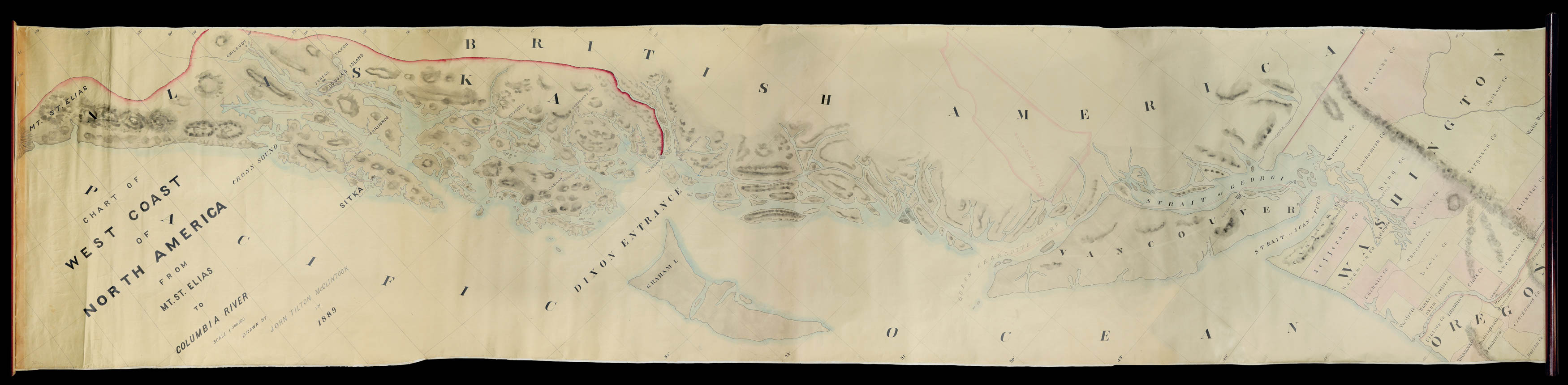
This manuscript by New Hampshire native John Tilton McClintock depicts the northwest coast from the Alaska panhandle to Tillamook County, Oregon.
The son of an expert surveyor and himself a future architect, McClintock—in his late teens at the time—was already an accomplished draftsman. His map shows the complex coastal outline and the region's many islands, employs shading to indicate in a general way the many mountains and mountain ranges, names major geograph...
This manuscript by New Hampshire native John Tilton McClintock depicts the northwest coast from the Alaska panhandle to Tillamook County, Oregon.
The son of an expert surveyor and himself a future architect, McClintock—in his late teens at the time—was already an accomplished draftsman. His map shows the complex coastal outline and the region's many islands, employs shading to indicate in a general way the many mountains and mountain ranges, names major geographical features and towns, and outlines county boundaries in Oregon and Washington. This data is superimposed on a carefully-drawn coordinate grid.
The intent of the map appears to have been to illustrate or memorialize a round-trip journey from Puget Sound to Glacier Bay for the benefit of friends or family back home. The voyage track is shown in red ink, with a few July dates indicated in Alaska, apparently the dates of landfall at different ports of call. Just east of Queen Charlotte Sound McClintock provides an outline map of New Hampshire to convey a sense of the region's massive scale.
John Tilton McClintock (1872-1929)
McClintock was born April 23, 1872 in Concord, New Hampshire and died at Wollaston, Massachusetts on Dec. 20, 1929. His father John Norris McClintock (1846-1914) was an accomplished surveyor and civil engineer whose career included an eight-year stint with the U.S. Coast Survey, during which time he was involved in geodetic and topographical surveys as far afield as Texas and Lake Champlain. The elder McClintock later settled in New Hampshire and then in Dorchester, Massachusetts and received a number of patents related to sewage treatment and sewer construction. In 1898 or 1899 he founded the American Sewage Disposal Company of Boston.
John Tilton McClintock was at Harvard from 1894-97, though the first Report of the Class of 1898 (published that same year) describes him as a "temporary member." The Report indicates that he was living on Beacon Street in Boston, practicing as an architect, and Secretary of the Board of the American Sewage Disposal Company. Apparently both the Sewage Disposal Company and his architecture practice operated from the same office at 89 State Street. Also in 1898 he married Grace Lang Coffin in Boston, from whom he was divorced ten years later and remarried to one Gertrude Elizabeth Rogers Sears.
McClintock's name shows up in OCLC associated with three maps and views of southeastern Massachusetts localities, all published in the 1890s and two of which were published by Boston lithographer Geo. H. Walker & Co. At the time this description is being written our firm also has a promotional plan for the town of Niagara, North Carolina, drawn by McClintock and published by Walker.
Unfortunately, McClintock's manuscript map of the Northwest leaves it unclear whether he is recording his own travels or those of another. The limited biographical information located for him provides no indication he made such a voyage. One possibility is that the map is based on a draft or notes produced during a trip made by his father, though for now this remains a hypothesis.