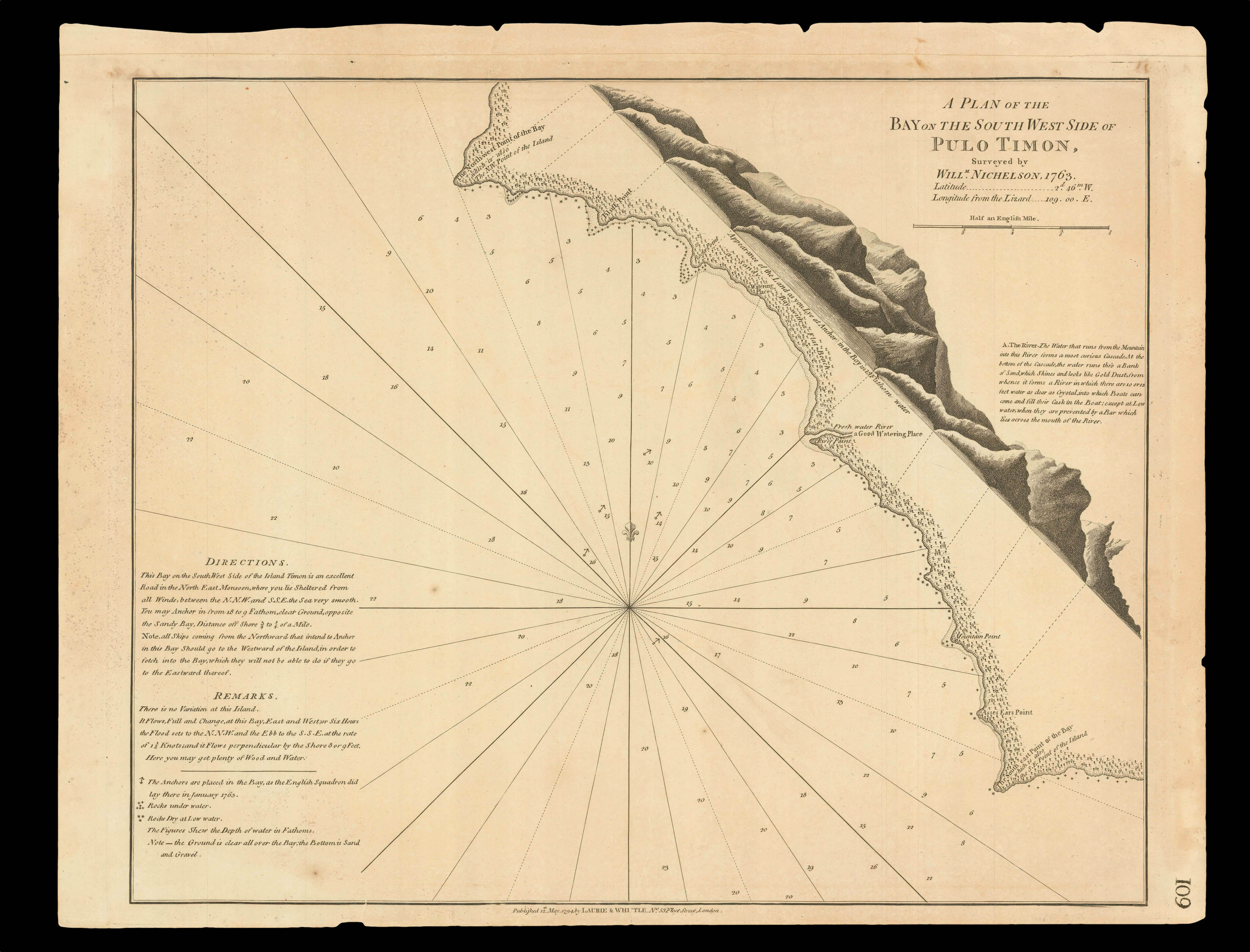
A chart of Nipah Bay, on the southwest coast of Tioman island off the east coast of the Malay Peninsula, based on the surveys of Captain Nichelsen made aboard the 'Elizabeth' during his voyage to the East Indies between 1758 and 1764. It was first published by Robert Sayer and John Bennett in their 'Oriental Pilot' (1778).
The chart clearly shows the location of the "Fresh Water River a Good Watering Place", and the island was important to all vessels in the are...
A chart of Nipah Bay, on the southwest coast of Tioman island off the east coast of the Malay Peninsula, based on the surveys of Captain Nichelsen made aboard the 'Elizabeth' during his voyage to the East Indies between 1758 and 1764. It was first published by Robert Sayer and John Bennett in their 'Oriental Pilot' (1778).
The chart clearly shows the location of the "Fresh Water River a Good Watering Place", and the island was important to all vessels in the area for that reason, and also, as the "Directions" note, because: "This Bay on the SouthWest Side of the Island Timon is an excellent Road in the North East Monsoon, where you lie Sheltered from all Winds, between the N.N.W. and S.S.E. the Sea very smooth. You may Anchor in from 18 to 9 Fathom, clear Ground, opposite the Sandy Bay". The remarks share very detailed information about how to successfully approach the Bay and anchor there, which is further illustrated in the very large and detailed coastal profile that extends the length of the charted coastline.
The chart is from an early edition of Laurie & Whittle's rare 'East India Pilot', and one of the first charts published after their purchase of Robert's Sayer's business. Laurie & Whittle's 'East India Pilot' was published as a practical guide to navigators aboard ships of the Royal Navy and East Indiamen, and often taken to sea, and this chart appears to be no exception, as it is gently waterstained. All variants of Laurie and Whittle's 'Oriental' pilots of eastern waters are scarce, and were published under several titles, each with a different complement of charts. Variants include: 'The Country Trade East-India Pilot, for the Navigation of the East-Indies and Oriental Seas, within the limits of the East-India Company', 'The Complete East-India Pilot, or Oriental Navigator', 'The East-India Pilot, or Oriental Navigator', and 'The Oriental Pilot; Or, East-India Directory' focusing on the most important charts used for the journey.
The foundation of the partnership of Robert Laurie (1755–1836) and James Whittle (1757–1818) was the existing stock of Robert Sayer's printing plates, both for maps and atlases and also decorative prints. Laurie had originally apprenticed to Robert Sayer in 1770, and made free in 1777. He was a skilled artist, who exhibited at the Society of Artists from 1770, winning a silver palette for a drawing in 1770, and he was also an accomplished engraver of mezzotint portraits and produced views and other decorative items. In about 1792 he returned to the Sayer business and took it over from the ailing Sayer in 1794. Whittle was apprenticed into the Needlemakers' Company, evidently made free by 1792, and joined with Laurie to take over the Sayer business in 1794.
Laurie retired in 1812. His son Richard Holmes Laurie replaced him in the partnership and, eventually, took over the firm after Whittle's death in 1818. Presumably under the influence of Richard Holmes Laurie, the partnership became noted as chartmakers and publishers, with the business existing to the current day as Imray, Laurie, Norie and Wilson.