New Edition 27th Dec., 1922. Small corrections to 1923.
Engraved chart, including tidal information, compass roses, soundings, seabed notations, currents, sandbanks, shoals, lighthouses and beacons picked out in yellow and red, inland elevations and detailing, text below title pasted on.
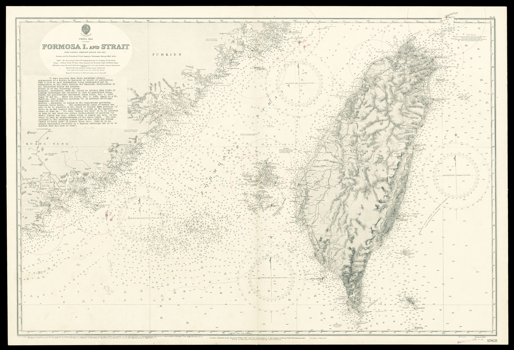
Detailed chart of Taiwan Island and Taiwan Straits.
Taiwan at the time of the chart's publication was under the control of the Japanese, who in 1895 had gained control of the island from the Chinese after the First Sino-Japanses War. The text below the title details the latest advice to mariners on the China Station, and shows Japan's growing influence in the area:
"I have received from their Lordships advance information of a Notice to Mariners in cou...
Detailed chart of Taiwan Island and Taiwan Straits.
Taiwan at the time of the chart's publication was under the control of the Japanese, who in 1895 had gained control of the island from the Chinese after the First Sino-Japanses War. The text below the title details the latest advice to mariners on the China Station, and shows Japan's growing influence in the area:
"I have received from their Lordships advance information of a Notice to Mariners in course of publication with a view to such information being promulgated now to authorities on the China Station for immediate distribution to all interested bodies and persons. Notice is to the following effect: Locality, Pescadores, Bako Ko, should be deleted from lists of Typhoon anchorages and included in list of prohibited areas. Charts and publications concerned: Japan Pilot, Vol. 1, 1926, Pages 29 and 30. China Sea Pilot, Vol. 5, 1926, Pages 19 & 59. Chart No. 1961 Reference position "A" in Latitude 23-33-OON, Longitude 119-32-52E. Details - Attention is called to the Regulations governing Japanese Naval Ports. The Northwestern limit of Number two area is to be inserted on the chart as follows from position "A" above in an 048 degrees direction to a point on the opposite shore of Bako Ko. The note "number two area" is to be inserted in Bako Ko and about six cables Southeastward of position "A" above, Number two area, within which is number one area, is the whole of Bako Ko southeastwards of the above limit. The area enclosed by the existing pecked line on the chart and marked "Limit of Naval Port" is number three area. Bako Ko is no longer considered available as a typhoon anchorage and is to be deleted from the list of such".
The British Hydrographic Office was founded in 1795 by George III, who appointed Alexander Dalrymple as the first Hydrographer to the Admiralty. The first charts were produced in 1800. Unlike the U. S. Coast Survey the Hydrographic Office was given permission to sell charts to the public and they produced a great number of sea charts covering every corner of the globe. Most of the Admiralty charts produced by the Hydrographic Office delineated coastline as well as high and low water marks and record depth of water as established by soundings. In addition these charts included information on shoals, reefs, and other navigational hazards that plagued mariners across the world. Thanks to the innovations of Sir Francis Beaufort, who developed the Beaufort Scale of wind strength, the British Hydrographic Office became one of the leading producers of sea charts. In fact, such was their accuracy that the phrase 'Safe as an Admiralty Chart' was coined.