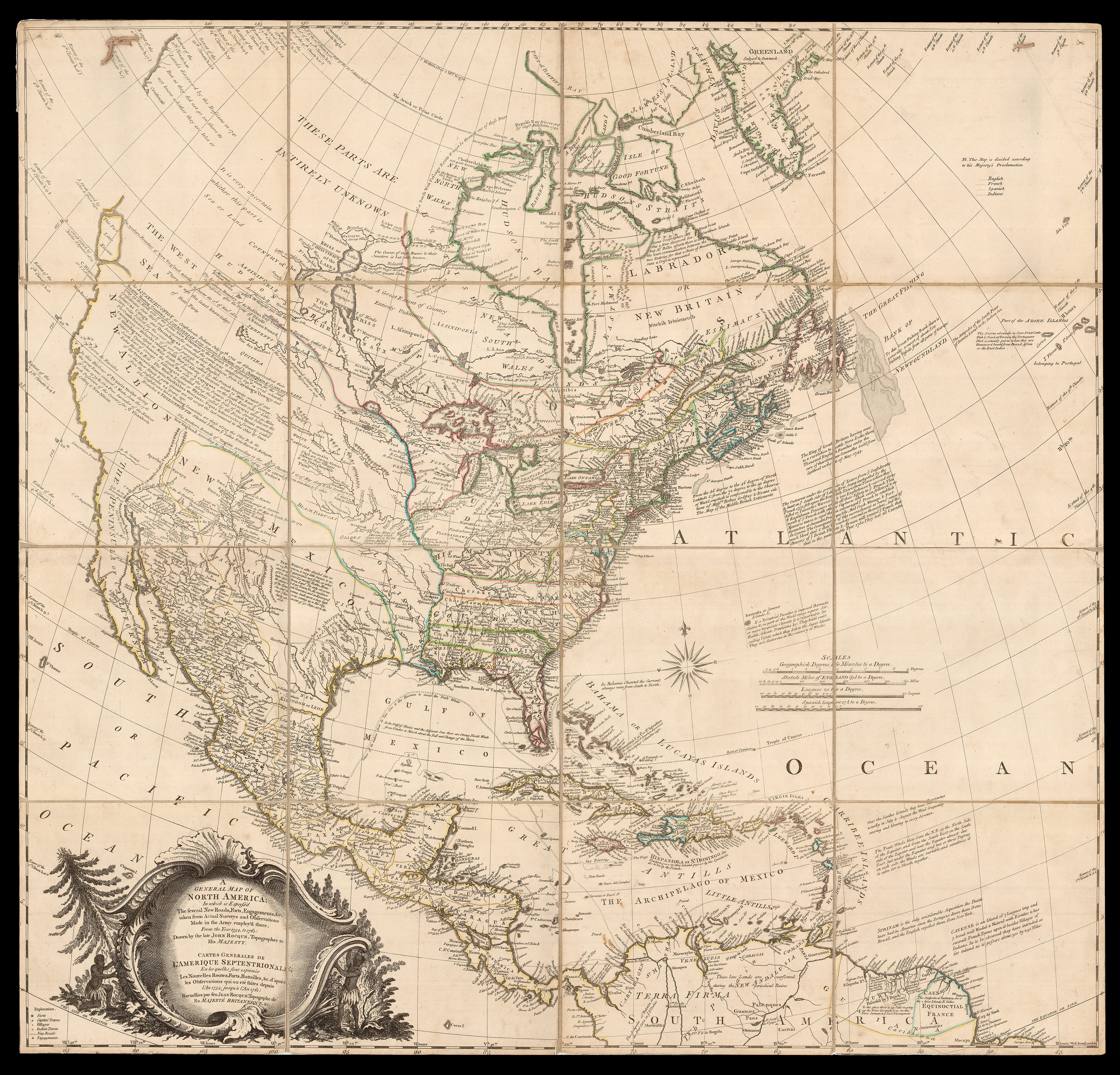
Drawn by "the late John Rocque, topographer to his majesty", shortly before his death in 1762, this highly detailed map of North America was the most accurate to date, replete with topographical information, and annotations which would have been of considerable use to both the English and the French as they entered the final stages of the campaign that would be known as the "French and Indian War" in America, an extension of the Seven Years' War (1756-1763), in Europe. A...
Drawn by "the late John Rocque, topographer to his majesty", shortly before his death in 1762, this highly detailed map of North America was the most accurate to date, replete with topographical information, and annotations which would have been of considerable use to both the English and the French as they entered the final stages of the campaign that would be known as the "French and Indian War" in America, an extension of the Seven Years' War (1756-1763), in Europe. A great global conflict, that Winston Churchill called the "first world war", which would encompass not only France and England, but also West Africa, the Caribbean, the Philippines, and India. In America, it would involve three great territorial empires: England, France, and the Iroquois Confederacy (an alliance of the Mohawk, Oneida, Onondaga, Cayuga, and Seneca nations).
Not only is the title in English and French, but the map is filled with notes locating the settlements, relevant boundaries of the English, French and native American tribes, and often vivid descriptions of the three-way conflict and its ramifications. For example a lengthy account of the decisive raid on Pickawillany, in June of 1752: "The Outaweis [i.e. Odawa] under the pretence of Leave from y.e confederates to hunt on ye South side of Lake Erie, being instigated by the French 1752 fell upon the English Tawixtwie Town where they killed 22 Tawixtwi Warriors [i.e. Twightwees, or Miamis] & one Englishman & carried away 6 Englishmen Prisoners with all the Effects to ye French This insult of ye French with other Captures wich soon followed & no Measure taken to repel them encouraged ye French to establish themselves at Junandat, Presque Isle, mad Creek, Winingo, & Fort du Quesne. The consequence of this incroachment as been ye cause of much blood shed, & their Treachery retorted on themselves, And the Bravery of ye British Fleets & Armies will remind ye French that that in the memorable Year 1760 They lost all Canada".
"This is an interesting map for the Mississippi Valley and the country to the west, and especially good for what is now Arizona. It shows all the villages named for the Apostles on Rio des Apostres, now called the Gila, and here in its upper reaches called the Hila" (Streeter).
The map also notes the landing place of Christopher Columbus in 1492, the route of the Spanish treasure ships through the islands of the Caribbean, and details of trade winds, and even hurricanes: "Near the Caribee Islands they have Hurricanes usually in July & August the Wind frequently veering and blowing in every direction".
Scrupulously compiled by John Rocque, from named sources, such as Lewis Evans's map, considerable effort has been made to include the latest information, and accompanying uncertainties, about the territory west of the Mississippi: Fort Orleans appears on the Missouri, which is followed northwest, with a few breaks, to a lake near the southern boundary of the Hudson's Bay Company, where a note states: "it is not yet determined whither this River is the source of the Missourie or not". Further south, in savage Panimalia country, another tributary peters out, with "the Head not discovered".
And, destiny is manifest in the trans-continental boundaries of New England and Virginia.
Following Rocque's death in 1762, his wife, Mary Ann "administered his estate and carried on his map business for six years as the publisher of his works. This 1761 map of America published by "M.A. Rocque" was protected by an Act of Parliament, as was stated under the bottom neatline, meaning that it was copyrighted and there were penalties for stealing the design and reusing it under another name. Mary Ann sometimes used her initials in the imprint, as on this map. Consequently, much of her work was unrecognized as that produced by a woman in the map trade" (Norman B. Leventhal Map & Education Center).
The mapmaker
John Rocque (c1704-1762) was also of French origin, a Huguenot exile, who probably came to London from Geneva in about 1728. Rocque lived in Great Windmill Street, on the edge of the French quarter, in Soho until 1743. After a fire destroyed everything he owned in 1750, he purchased new stock in Paris and re-established his business in the Strand, at the centre of the London map trade. His first publications were elaborate plans of the parks and estates of the monarchy and gentry; these were vanity publications, which survive in small numbers, but they served as a important introduction to wealthy patrons. He followed this with a series of important plans of English cities and towns. As with the estate plans, he was benefiting from the growing wealth in England after the War of the Spanish Succession.
The work is rare on the open market, with only two examples appearing at auction in the last 30 years.
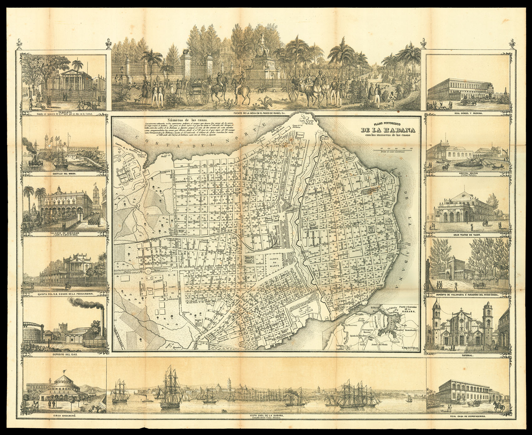 May's plan of Havana
1 × £4,000
May's plan of Havana
1 × £4,000![PARSONS, J[ohn] West Indies. Island of Grenada](https://omega.crouchrarebooks.com/wp-content/uploads/2025/03/12869_1H.jpg) Parson's chart of Grenada
1 × £1,000
Parson's chart of Grenada
1 × £1,000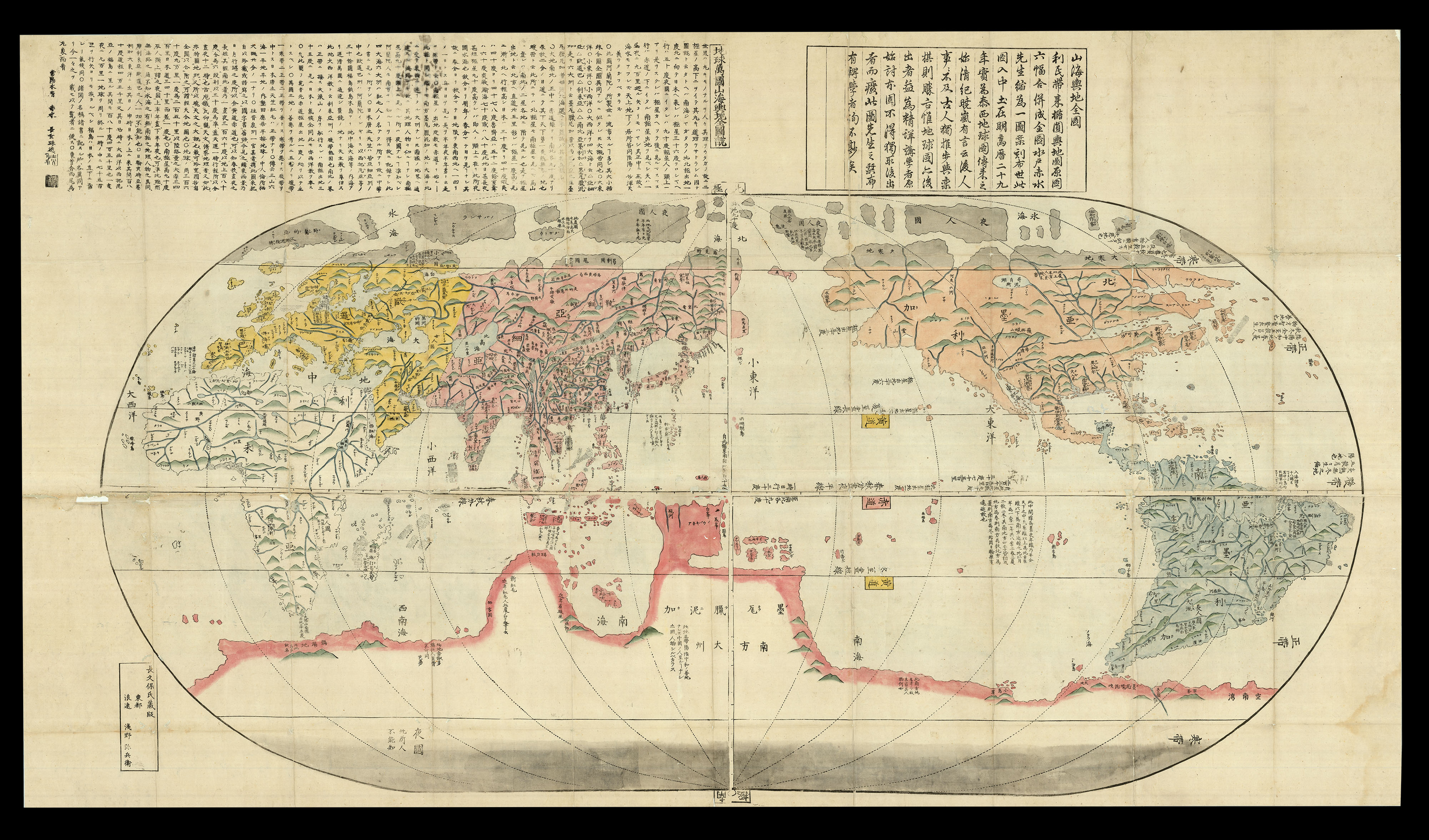 The first Japanese world map with latitudes and longitudes
1 × £20,000
The first Japanese world map with latitudes and longitudes
1 × £20,000