Exhibiting particularly the nautical researches of Captain James Cook, F.R.S. with all the recent discoveries to the present time, carefully drawn by A. Arrowsmith, Hydrographer to H.R.H. the Prince of Wales.
Large engraved wall map on six sheets, fine original outlined hand colour, few tears to margins, tear to lower part of western hemisphere, just into image.
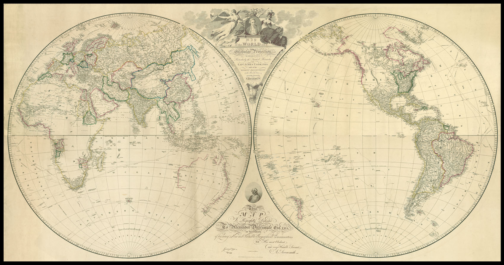
The map, first published in 1794, is on the same scale - five equatorial degrees to one inch - as Arrowsmith's 1790 'Chart of the World on Mercator's Projection'. It was, he states, to be a companion piece to the former map 'in order to exhibit the contrast between the two best projections upon which general maps of the world can be constructed.'
The map is typical of Arrowsmith's work. All accumulated myth, misconception, and guesswork are stripped away, making ...
The map, first published in 1794, is on the same scale - five equatorial degrees to one inch - as Arrowsmith's 1790 'Chart of the World on Mercator's Projection'. It was, he states, to be a companion piece to the former map 'in order to exhibit the contrast between the two best projections upon which general maps of the world can be constructed.'
The map is typical of Arrowsmith's work. All accumulated myth, misconception, and guesswork are stripped away, making for a sparse and elegant style with decorative flourishes left for the borders. All three of Cook's voyages are plotted, each being highlighted in colour: 1768-1771 green; 1772-1775 red; and the 1776-1779 voyage starts in blue, but after Cook's death on Hawaii is subsequently marked in black.
The elaborate title cartouche contains a portrait of Cook flanked by a winged Victory and Britannia, and surrounded by navigational instruments. Arrowsmith dedicates the map to Alexander Dalrymple, one of the foremost hydrographers of his day, who had recently been appointed director of the newly-founded British Hydrographical Office.
Aaron Arrowsmith (1750-1823) was the finest cartographer of his generation. Although he received little formal education it is believed that he was taught some mathematical instruction by William Emerson, an author of several books on the application of mathematics to the area of cartography. Around 1770, Arrowsmith moved to London to seek employment. It is believed that he worked for William Faden before joining John Cary Sr. in the early 1780s. There he provided the measurements for John Cary's early publication detailing the roads from London to Falmouth, his first signed work. Arrowsmith set up on his own in 1790 and over the next thirty years produced some of the most beautiful and elegant maps of the era.