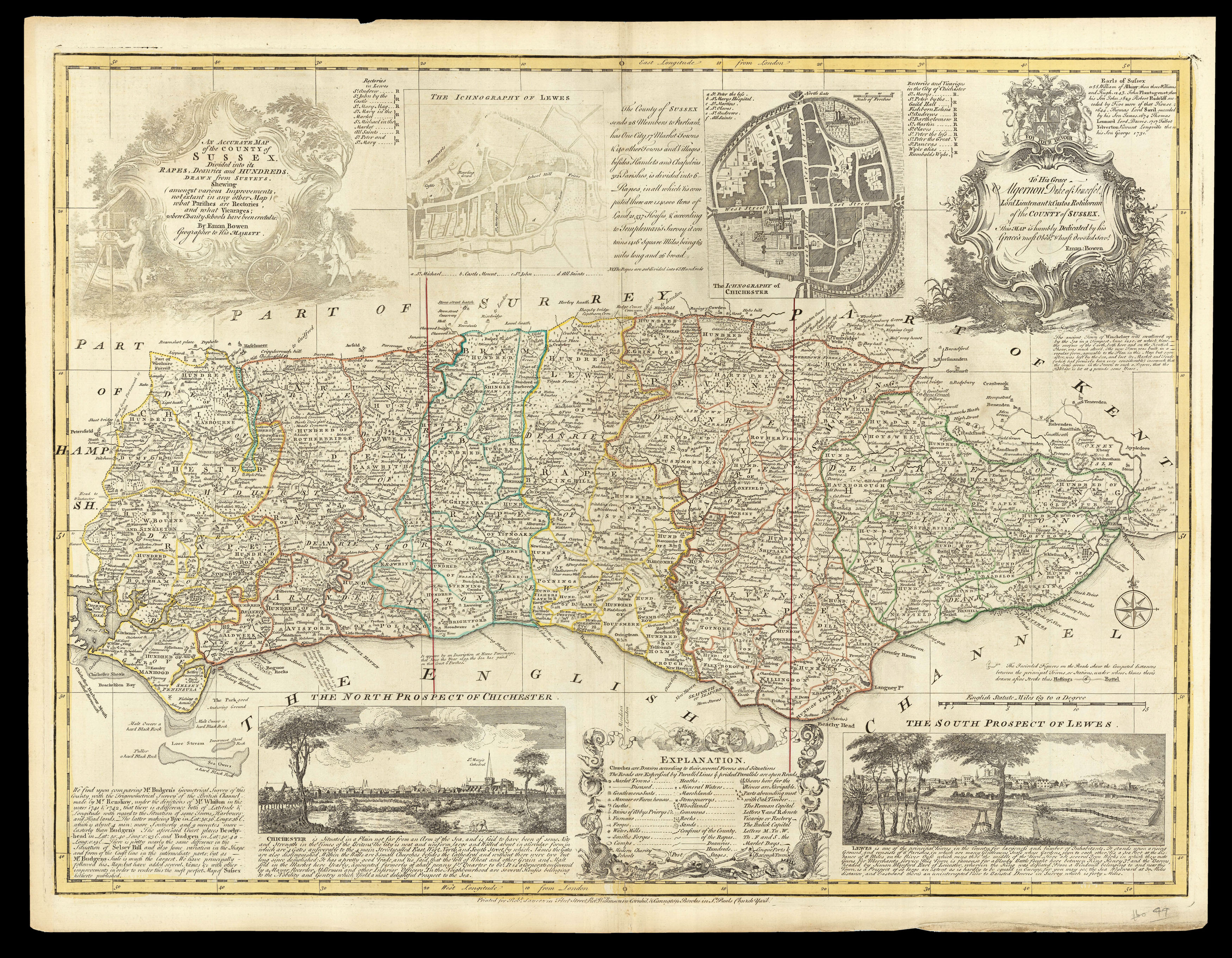
Divided into its Rapes, Deaneries and Hundreds. Drawn from Surveys. Shewing (Amongst various Improvements, not extant in any other Map) what Parishes are Rectories and what Vicarages; where Charity Schools have been erected &c.
With three inset vignettes: 'The Iconography of Chichester', 'The North Prospect of Chichester', 'The South Prospect of Lewes', and dedicated to Algernon, Duke of Sussex; and numerous legends.
Emanuel Bowen's (c1693-1767) map of Sussex is based on Philip Overton and Thomas Bowles's c1726 map of the County, in turn a reduction of Budgen's large-scale map first published in 1724 - the first large-scale map of the county. The current map was printed many times, incl...
With three inset vignettes: 'The Iconography of Chichester', 'The North Prospect of Chichester', 'The South Prospect of Lewes', and dedicated to Algernon, Duke of Sussex; and numerous legends.
Emanuel Bowen's (c1693-1767) map of Sussex is based on Philip Overton and Thomas Bowles's c1726 map of the County, in turn a reduction of Budgen's large-scale map first published in 1724 - the first large-scale map of the county. The current map was printed many times, including in 1749 by Robert Sayer and John Bowles, and again by Robert Sayer, Thomas Bowles & John Bowles, in about 1763.
The Sayer, Overton, and Bowles families were closely related. Robert Sayer (c1725-1794), a leading London print- and mapseller, mapmaker and publisher. In January 1747, his elder brother James jr. had married Mary Overton, widow of the print- and mapseller and publisher Philip Overton. By December of 1748, he had taken over the firm which he ran until 1792. The Overton business was principally in good quality decorative prints, caricatures, portraits and imported prints, with a few maps. This gave him a substantial stock to which he added selectively, at first working in partnership with other publishers, notably Thomas Bowles (II) and John Bowles but also William Herbert.
The Bowles family business was established by Thomas Bowles (I) (d1720). He was followed into business by his two sons, Thomas (II) and John (1701-1779); the business was transferred to Thomas (II) in about 1714, with the agreement that he would pay a total of £1,000 to John when he came of age, so he could set up his own business. Thomas (II) (1688–1767) went on to become a leading, and highly successful, London printseller and publisher. In about 1753, John was joined in partnership by his son Carington (1724-1793), who with Sayer and Robert Williamson, published this issue of the map.
Robert Wilkinson (fl1758-1825), who operated as a printseller at 58 Cornhill from 1780-1815, and Carington Bowles also seem to have had a close relationship, both published images of the famous painting by Henry Walton, 'A Girl Buying a Ballad' (1778) in the 1780s.