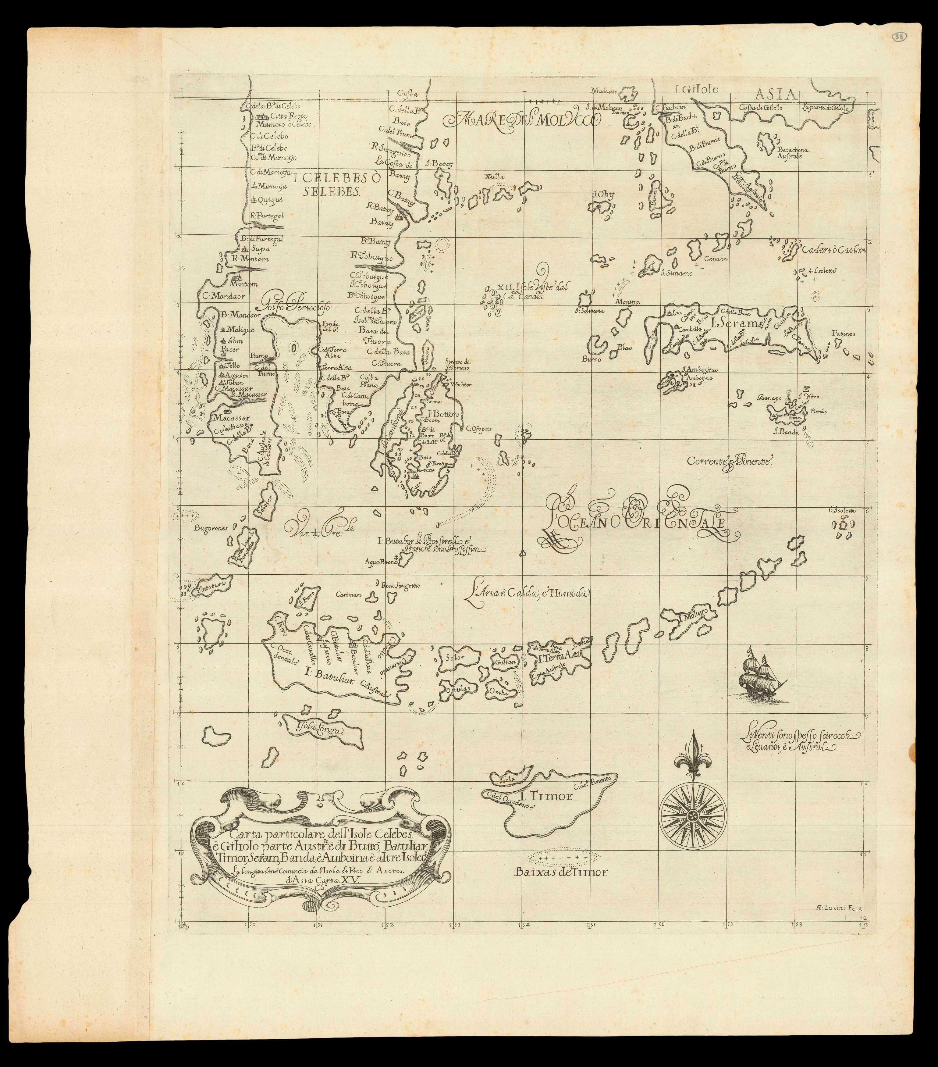
Dudley's beautiful chart of Indonesia, from the Celebes in the north, to Timor in the south, which guarded the southern routes to the Spice Islands, showing shoals, and names of coastal features, capes, rivers and settlements. The Portuguese first settled on Timor in 1520, and the Spanish arrived in 1522. The Dutch took possession of the western portion of the island in 1613. Thereafter, until the twentieth century, the Dutch and the Portuguese struggled for supremacy of th...
Dudley's beautiful chart of Indonesia, from the Celebes in the north, to Timor in the south, which guarded the southern routes to the Spice Islands, showing shoals, and names of coastal features, capes, rivers and settlements. The Portuguese first settled on Timor in 1520, and the Spanish arrived in 1522. The Dutch took possession of the western portion of the island in 1613. Thereafter, until the twentieth century, the Dutch and the Portuguese struggled for supremacy of the island, with East Timor being virtually all that eluded the Dutch domination of Indonesia.
Information regarding the islands of Ambon, Seram and Banda was strictly controlled in order to protect the VOC's effective monopoly on the trade in nutmeg and cloves. "Having calculated that their market could be supplied from the clove production on Ambon alone, it set about destroying all the clove trees on Seram though happily without complete success. This policy was more effective, however, on the small island of Pulau Run, where the VOC succeeded in extirpating all the nutmeg trees that grew there, thereby ensuring that the English, who had been allowed to remain on a tiny coral islet just to the north of the island could not profit from their fruit" (Suarez 235).
The Bandanese refused to cooperate with the VOC demands for exclusive rights to their nutmeg, and so were effectively erased from the map in 1621. The VOC divided the islands into plantations which were leased to former Company employees who had stayed on after their term of service. They were given slaves to work the land, and the VOC bought their crops at fixed prices.
From the second edition of 'Dell'arcano del mare', one the "greatest atlases of the world" (Wardington), first published in 1646 when its author, Robert Dudley, was 73. It was not only the first sea atlas of the world, but also the first to use Mercator's projection; the earliest to show magnetic deviation; the first to show currents and prevailing winds; the first to expound the advantages of 'Great Circle Sailing' – the shortest distance between two points on a globe; and "perhaps less importantly the first sea-atlas to be compiled by an Englishman, albeit abroad in Italy" (Wardington).
Robert Dudley (1574-1649) was the son of the Earl of Leicester (the one time favourite of Elizabeth I) and Lady Douglas Sheffield, the widow of Lord Sheffield. Although born out of wedlock, Robert received the education and privileges of a Tudor nobleman. He seems to have been interested in naval matters from an early age, and in 1594, at the age of 21, he led an expedition to the Orinoco River and Guiana. He would later, like all good Tudor seamen, sack Cadiz, an achievement for which he was knighted.
His success upon the high-seas was not matched, unfortunately, by his luck at court, and at the beginning of the seventeenth century he was forced to flee, along with his cousin Elizabeth Southwell, to Europe. Eventually, in 1606, he ended up in Leghorn, Italy, which he set about turning into a great international naval and commercial seaport, in the service of Ferdinand I. Dudley, successful at last, married his cousin, converted to Catholicism, helped Ferdinand wage war against the Mediterranean pirates, by designing and building a new fleet of fighting ships for the Italian navy, served as Grand Chamberlain to three Grand-Duchesses of Tuscany in succession: Maria Maddelena, widow of Cosimo II; then Christina of Lorraine, widow of Ferdinand I; then to Vittoria della Rovere, Princess of Urbino, and wife of Ferdinand II, who created Dudley Duke of Northumberland.
bibliography:
bibliography:
Suarez 'Early Mapping of Southeast Asia', pages 205-207