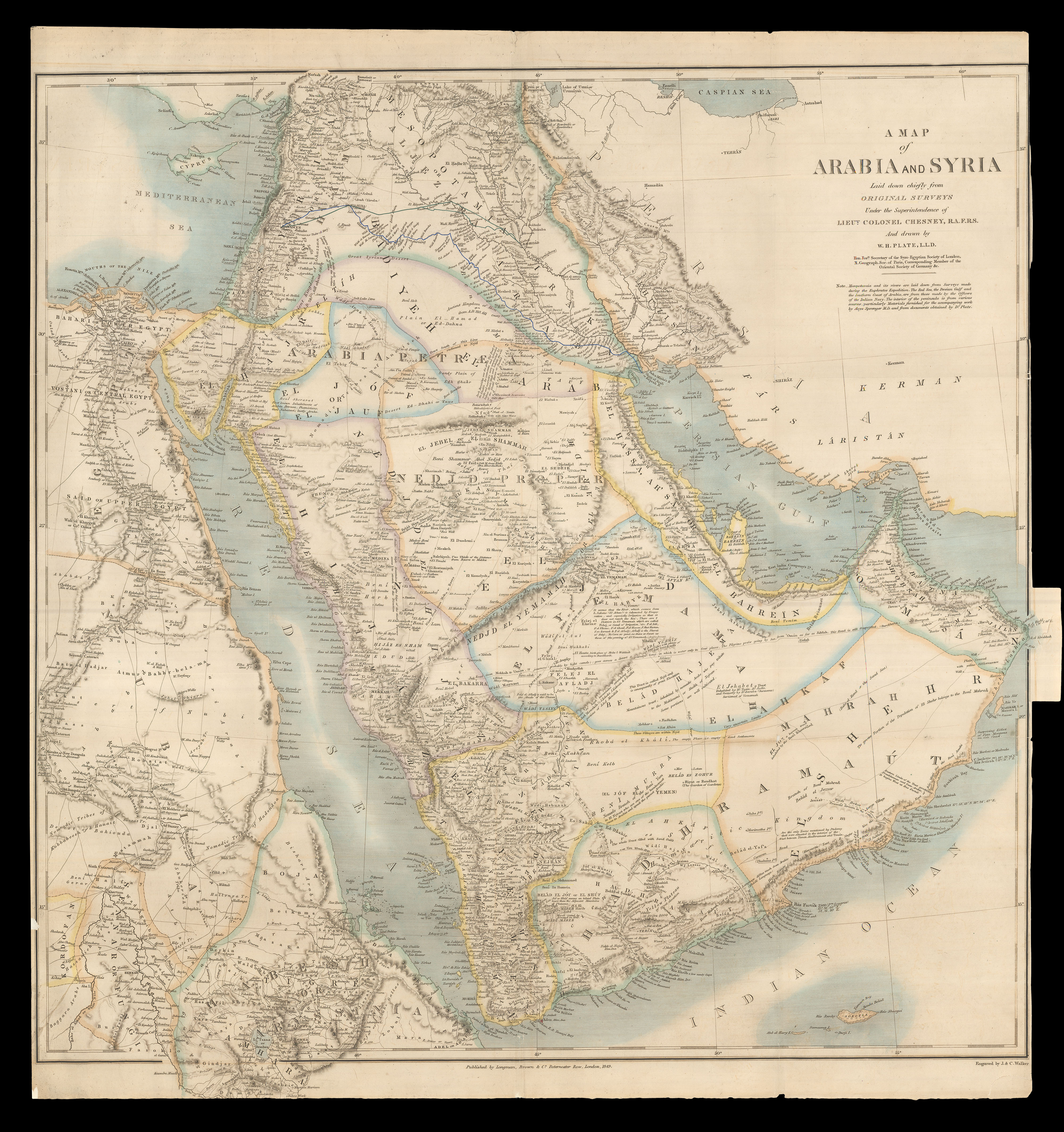
Beautifully engraved map of Arabia and Syria.
The present map was published in 1849, a revised edition of a map first published in 1847, under the title "Arabia", of which only one institutional example is known, held at the British Library.
Cartographically, it is a compilation of various sources. As the note underneath the title explains: "Mesopotamia and its rivers are laid down from Surveys made during the Euphrates Expedition. The Red Sea, the...
Beautifully engraved map of Arabia and Syria.
The present map was published in 1849, a revised edition of a map first published in 1847, under the title "Arabia", of which only one institutional example is known, held at the British Library.
Cartographically, it is a compilation of various sources. As the note underneath the title explains: "Mesopotamia and its rivers are laid down from Surveys made during the Euphrates Expedition. The Red Sea, the Persian Gulf and the Southern Coast of Arabia, are from those made by the Officers of the Indian Navy. The interior of the peninsula is from various sources, particularly Materials furnished for the accompanying work by Aloys Sprenger M.D. and from documents obtained by Dr Plate".
General Francis Rawdon Chesney (1789-1872) was a British soldier and explorer. Known for his proposal to build the Suez Canal, a proposal which would form the basis of Ferdinand de Lesseps's undertaking, he also oversaw an 1836 survey of the River Euphrates (likely the "Euphrates Expedition" mentioned in the note on the present map), in an attempt to open a faster route between England and India for the East India Company.
The Indian Navy was the naval arm of the English East India Company, which systematically charted the Arabian Coast between 1820 and 1839. In 1820, Captain George Barnes Brucks began to chart the Arabian Gulf; in 1829, Captains Elwon, Moresby, and Careless began to chart the Red Sea; and in 1837, Captain Haines would begin to chart Aden and the southern Arabian coast. So accurate were these surveys, designed to aid shipping, encourage trade, and suppress piracy, that they would become the standard works for much of the coast until well into the twentieth century, as the present map attests.
We have been unable to trace much information about William Henry Plate. He is named as the author of the 1847 "Arabia" map, also a collaboration with Chesney, and of a map of Asia Minor, published by Edward Stanford in around 1849.
Rarity
We have located only five institutional examples of this map: the National Library of Scotland, the University of Glasgow, Harvard University, the British Library, and Qatar National Library.