Large engraved wall map on 12 sheets, joined, contemporary outline hand colour. As is almost invariably the case with large seventeenth century wall maps, a certain amount of conservation work has been undertaken, including elements of re-touching to some of the coloured areas of the maps. A full conservation report is available on request. Mounted on linen on wooden stretchers.
In the Jubilee year of 1675 De Wit's large wall map of c. 1660 was redrawn on twelve sheets and published in Rome by Giovanni de Rossi under his latinised name Jacob de Rubeis. The engraver was Georgio Widman.
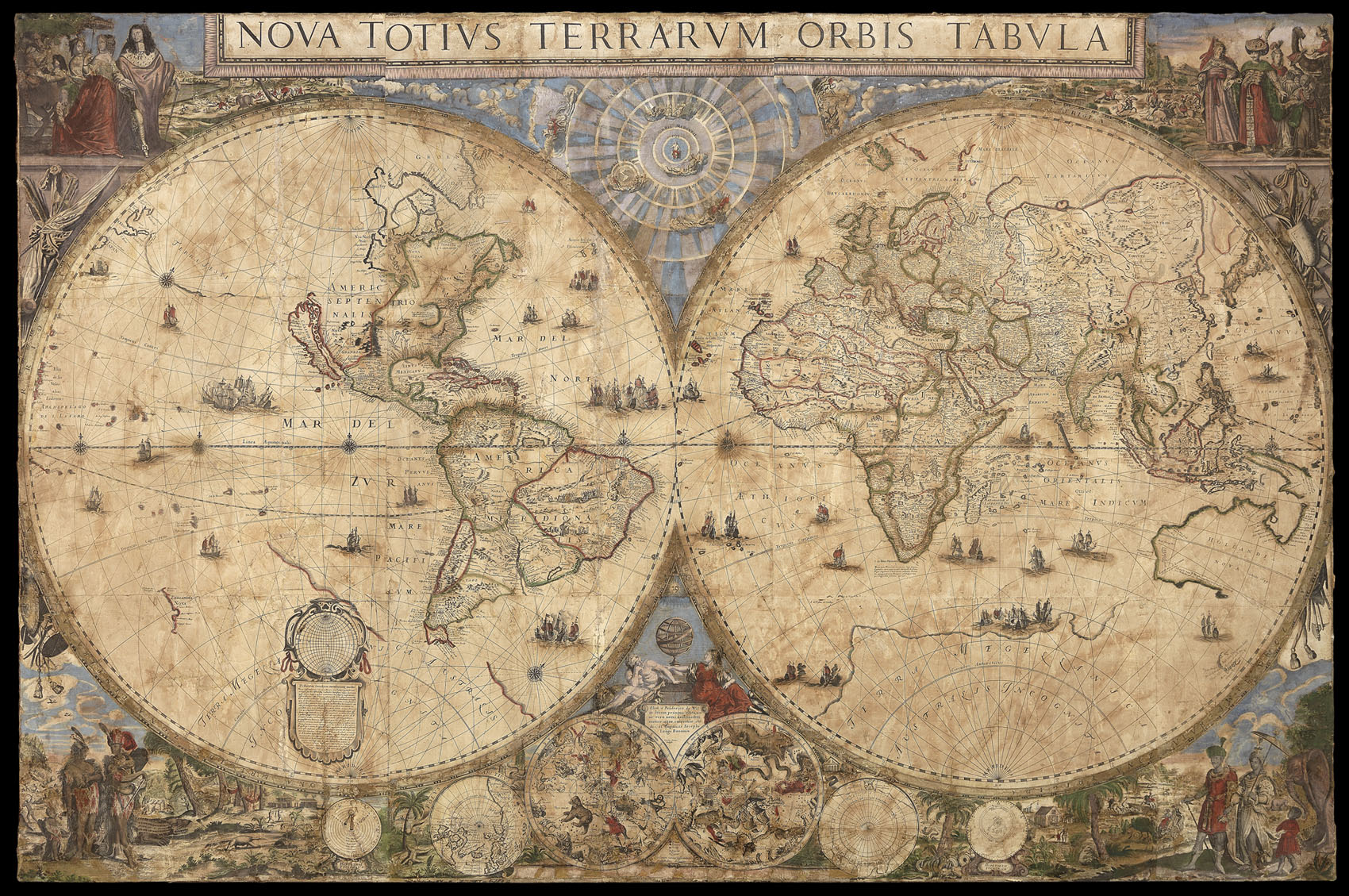
The size of the map approximates to that of De Wit's earlier twelve-sheet map and the geographical correspondence is very close. De Rossi has added the tentative coastline of Terra Jessi between North America and Japan and has brought back, in part, the coa...
In the Jubilee year of 1675 De Wit's large wall map of c. 1660 was redrawn on twelve sheets and published in Rome by Giovanni de Rossi under his latinised name Jacob de Rubeis. The engraver was Georgio Widman.
The size of the map approximates to that of De Wit's earlier twelve-sheet map and the geographical correspondence is very close. De Rossi has added the tentative coastline of Terra Jessi between North America and Japan and has brought back, in part, the coastline of the antarctic continent. There are two other changes which suggest an additional source: the large island in Hudson's Bay is now divided into three and the Desertum Amo (pocked to resemble sand) has been added in northern China. The positioning and style of the many small ships in the sea have been directly copied from De Wit, and there are similar ornate decorations around the hemispheres. The corner scenes depict personages of Europe, the Orient, Africa and South America against typical landscapes and hunting scenes. There is a large solar diagram at the top between the two main hemispheres: at the bottom are two celestial hemispheres, north and south polar projections, and circles representing the hypotheses of Ptolemy and Tycho Brahe. The design and engraving are of the highest standard.
Just above the two celestial hemispheres is a bust of Christina, Queen of Sweden who resided in Rome from shortly after her abdication in 1654 until her death in 1689. The main imprint is in a long panel below the hemispheres. At each side the map is flanked by eleven town views (making twenty-two in all) and below the map is text in Italian concluding in Latin: Romae Formis Io Iacobi De Rubeis.
Only one copy of the De Wit-De Rossi map is known (sold at Sotheby's London sale, 15 April 1980, lot 551) but several impressions of a very similar twelve-sheet world map are known. These are identical in size and all other features except for the imprint of Guiseppe Longhi of Bologna in place of Rossi's between the hemispheres and the addition, in the same place, of the signature of another engraver Carlo Scotti. The long panel at the bottom of the map in this instance is blank and Widman's signature does not appear. Longhi was a little-known printer whose name appears on a re-issue in 1676 of a large-scale map of Italy by Matteo Greuter. Carlo Scotti is known to have been active in Bologna in the 1680s. In all these impressions an arimillary sphere appears instead of the bust of Queen Christina, and the outer borders are absent.
It is uncertain whether the De Wit-Longhi issues pre-date the De Wit-De Rossi map or are later. A detailed examination of one of the De Wit-Longhi copies in the University of Kansas kindly undertaken for the author by Professor T.R. Smith disclosed no trace of any erasures or previous imprints. It could be that two very similar but distinct sets of plates are involved, although this seems unlikely. Apart from Kansas University, other examples of the De Wit-Longhi map (which, unlike the Rossi map, are undated) are to be found in the Newberry Library,Chicago, the Maritime Museum, Rotterdam, and the Istituto Geografico Militare, Florence. The date is generally attributed to c.1680.