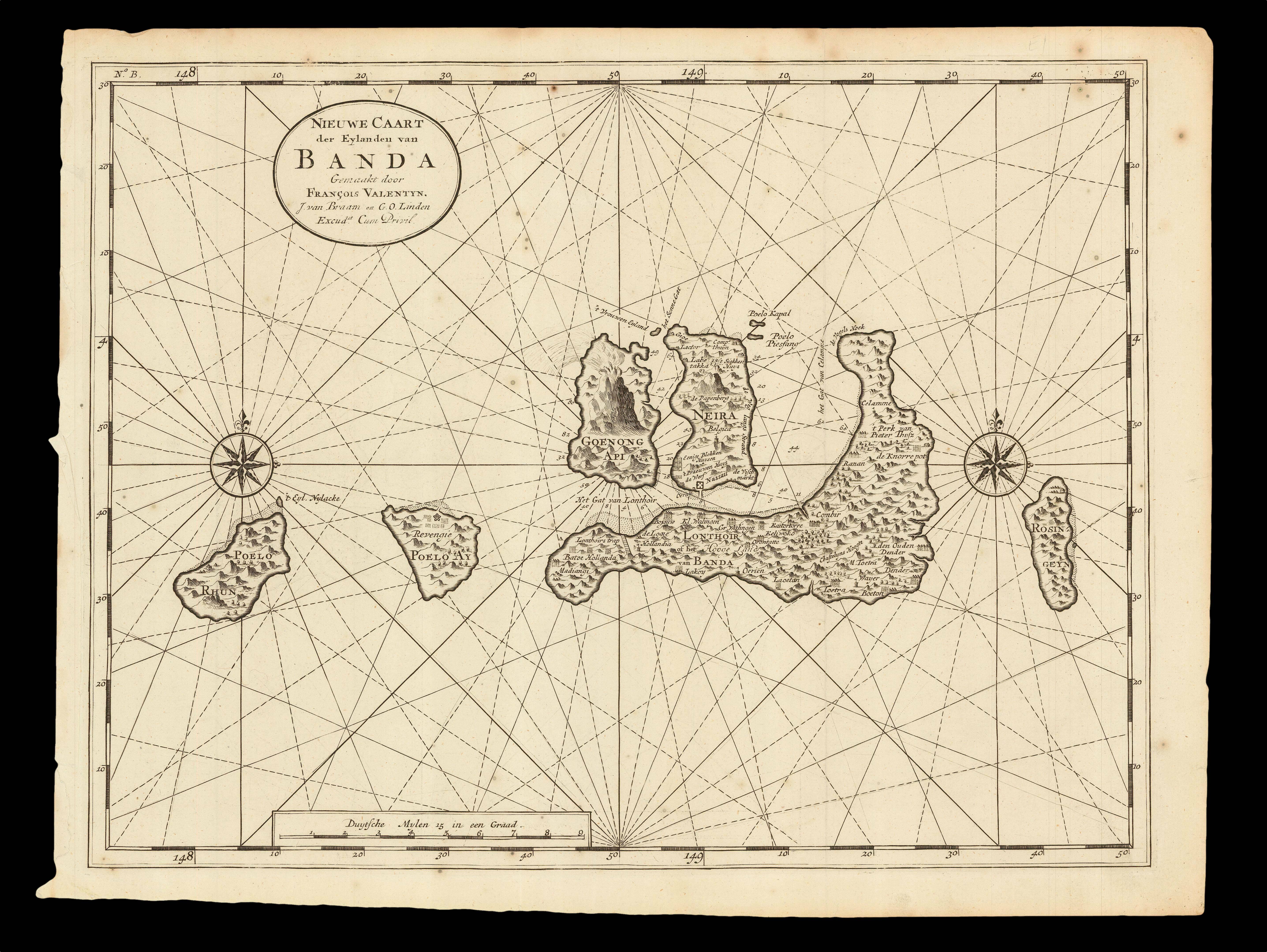
A large-scale and detailed chart of the Banda Islands, south of Seram Island in the Molucca Islands, in the Banda Sea, centred on the island of Gunung Api and its disruptive volcano. Published in Valentyn's 'Oud en Nieuw Oost-Indien, vervattende een Naaukeurige en Uitvoerige Verhandelinge van Nederlands Mogentheyd in die Gewesten', two volumes, an account of the history of the Dutch empire in Asia.
Information regarding the islands of Ambon, Seram and Banda was s...
A large-scale and detailed chart of the Banda Islands, south of Seram Island in the Molucca Islands, in the Banda Sea, centred on the island of Gunung Api and its disruptive volcano. Published in Valentyn's 'Oud en Nieuw Oost-Indien, vervattende een Naaukeurige en Uitvoerige Verhandelinge van Nederlands Mogentheyd in die Gewesten', two volumes, an account of the history of the Dutch empire in Asia.
Information regarding the islands of Ambon, Seram and Banda was strictly controlled in order to protect the VOC's effective monopoly on the trade in nutmeg and cloves. Lontor, Bandaneira, Run, Ai and Rozengain in the southern Moluccas "were the only producers of mace and nutmeg. It was on these islands that Jan Pietersz. Coen wreaked a gruesome havoc in 1621 and had nearly the entire indigenous population murdered or driven away. The rivalry with the English reached its peak in 1623 when, based on a rumor of a conspiracy against the Dutch, all of the Englishmen on the island of Run were put to death. The massacre was the source of much friction between the Netherlands and England for a long time after, but it did put an end to the English influence in the Moluccas. From that time onward, the two mighty forts of Belgica and Nassau protected the VOC's mace and nutmeg monopoly. After the bloody conquest, the VOC established a plantation on the Banda islands.
"The policy of the VOC was directed at safeguarding the monopolies of Ambon and Banda islands. In order to achieve this goal, the Dutch had also established themselves in the northern Moluccas. The felling of the wild nutmeg and clove trees, for which the Dutch concluded contracts with the indigenous sovereigns, was overseen from Fort Oranje on Ternate" (Schilder, page 52).
Francois Valentyn (1666-1727), a minister who devoted most of his life to the employ of the VOC, is responsible for publishing a comprehensive cartography of Southeast Asia. As a young man, in 1685, he was sent by the VOC to Ambon as a Minister to the East Indies, where he remained for a decade. In 1705, the now married Valentyn, and father of five children, returned to the Indies with his family. The following year he was Army Chaplain on an expedition in eastern Java, but suffered health problems and requested permission to return to Holland. This was denied, however, and he remained in the East until 1714. Finally, back home, Valentyn composed his monumental work, 'Oud en Nieuw Oost-Indien', which was published between 1724 and 1726.
The 'Oud en Nieuw Oost-Indien' was created both from the voluminous journals Valentyn had amassed during his two stays in Southeast Asia, as well as from his own research, correspondence, and from previously unpublished material secured from the VOC officials. The work contained an unprecedented selection of large-scale maps and views of the Indies, many of which were superior to previously available maps.
VOC — Vereenigde Oostindische Compagnie — Dutch East India Company
The VOC and its subsidiaries were the first joint stock companies in history, and the forerunners of modern corporations; eventually giving rise to a multi-national global empire, where money, and the ability to manipulate and move it, becomes the principal resource and driving force.
For nearly one hundred years, after Vasco da Gama discovered a sea route to India in 1499, the Portuguese and the Spanish were dominant in the eastern and western hemispheres respectively. This dominance was aided by a policy of extreme cartographic secrecy by both crowns, and returning ships were required to surrender both their charts and information on any discoveries made. All charts were state property, and illegal use or copying was punishable by death. However, smuggling often took place, and piracy by both English and Dutch vessels meant that, eventually, the routes to both the "Old", or East, and "New", or West, Indies became available to northern Europe. Using this purloined information, the British East India Company – EIC- and Dutch Vereenigde Oostindische Compagnie –VOC — were established — in 1600 and 1602 respectively — to cash in on the lucrative trade in nutmeg, pepper, cinnamon, cloves, and other spices.
These monopolistic giants continued the tradition of jealously guarding the secret charts that laid the path to the source of their immense wealth and power. Both organisations employed teams of chartmakers or hydrographers to record the most up-to-date navigational information for speedy distribution in order to obtain commercial advantage with the quickest routes to the most profitable markets. The principal vector for this information was the "pascaert".
The publication of these pascaerts proudly makes proprietary information inviting and accessible to a new investor class. In joining the chase around the globe for a nutmeg, one of the smallest countries in the world created a vast empire by applying the principle of capital investment to their ventures, eventually driving the Spanish, the Portuguese, and even the English from the East Indies.