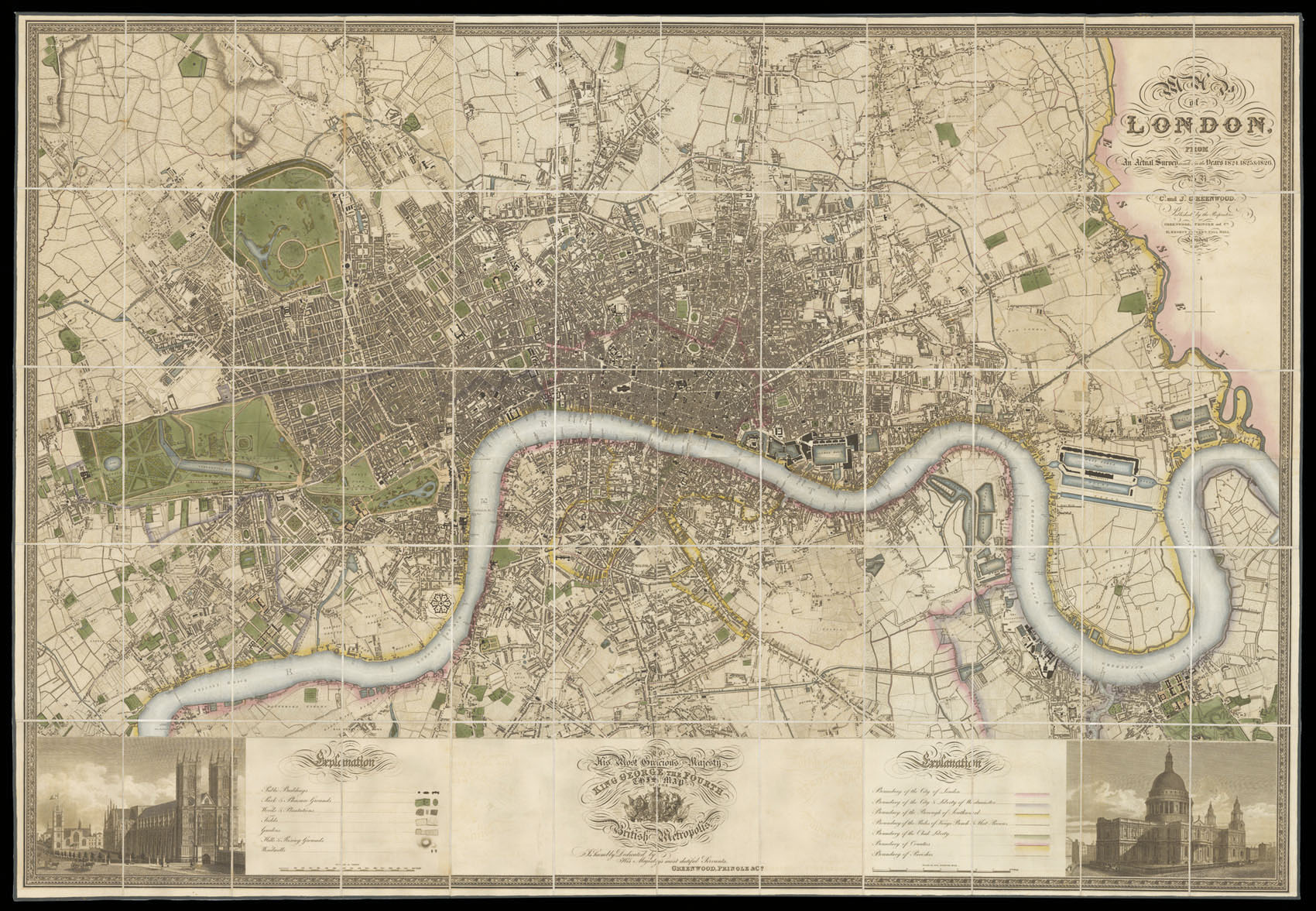
Christopher and John Greenwood state in the title that the plan was made from an "Actual Survey", which had taken three years. Plans at the time were often copied from older surveys, or re-issued with minor updating; so conducting a new survey was indeed something to boast about. The plan, which was finely engraved by James and Josiah Neele, is stylistically similar to the Ordnance Survey maps of the time, although it was engraved on a much larger scale of 8 inches to the m...
Christopher and John Greenwood state in the title that the plan was made from an "Actual Survey", which had taken three years. Plans at the time were often copied from older surveys, or re-issued with minor updating; so conducting a new survey was indeed something to boast about. The plan, which was finely engraved by James and Josiah Neele, is stylistically similar to the Ordnance Survey maps of the time, although it was engraved on a much larger scale of 8 inches to the mile, compared to the OS one inch to the mile. It includes detailed depictions of streets, houses, public buildings, parks, squares, woods, plantations, rivers, hills, windmills; also the marking of the boundaries of the City of London, Westminster, Southwark, Rules of the King's Bench & Fleet Prison, Clink Liberty, counties and parishes. Below the plan is a dedication to George IV, which is flanked by views of Westminster Abbey and St Paul's Cathedral.
![KIP, Johannes A Prospect of the City of London [with] A Prospect of Westminster.](https://omega.crouchrarebooks.com/wp-content/uploads/2025/03/12591_1H.jpg) London's calling
1 × £12,000
London's calling
1 × £12,000![DEAN, T.; [after] H.W. PICKERSGILL Aaron Arrowsmith Ætat. 72. Obiit. 1828.](https://omega.crouchrarebooks.com/wp-content/uploads/2025/03/17716_1H.jpg) Aaron Arrowsmith
1 × £500
Aaron Arrowsmith
1 × £500 In pursuit of Tantia Tope
1 × £6,000
In pursuit of Tantia Tope
1 × £6,000![[BRY, Theodor de] Soufrir por parvenir. Ioannis Hugonis a Linschoten Haerlememsis Æta 35 Aº 1598.](https://omega.crouchrarebooks.com/wp-content/uploads/2025/03/17721_1H.jpg) Jan Huyghen van Linschoten
1 × £550
Jan Huyghen van Linschoten
1 × £550![[ANONYMOUS] J. J. Scheuchzerus](https://omega.crouchrarebooks.com/wp-content/uploads/2025/03/17799_1H.jpg) Johann Jakob Scheuchzer
1 × £150
Johann Jakob Scheuchzer
1 × £150