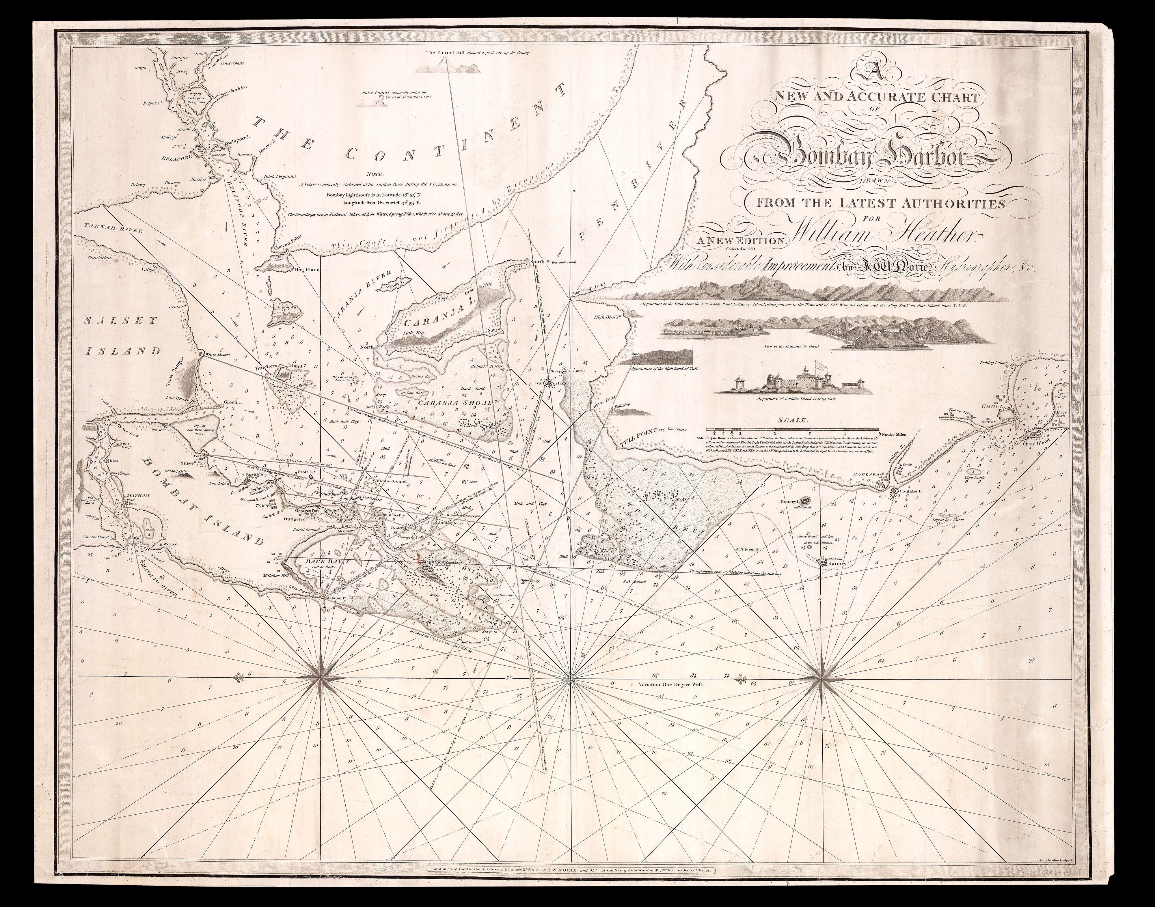
Rare and detailed chart of Bombay Harbour at the beginning of the nineteenth century.
Orientated east the chart shows "Bombay Island" (the modern-day city of Mumbai) to the left, with "Salset Island" (Salsette Island) to its north and east, and, at the top, "The Continent" (mainland India).
The Seven Islands of Bombay (Isle of Bombay, Mazagaon, Parel, Worli, Mahim, Little Colaba, and Colaba) had, since 1534, been part of the Portugese Empire. In 1661,...
Rare and detailed chart of Bombay Harbour at the beginning of the nineteenth century.
Orientated east the chart shows "Bombay Island" (the modern-day city of Mumbai) to the left, with "Salset Island" (Salsette Island) to its north and east, and, at the top, "The Continent" (mainland India).
The Seven Islands of Bombay (Isle of Bombay, Mazagaon, Parel, Worli, Mahim, Little Colaba, and Colaba) had, since 1534, been part of the Portugese Empire. In 1661, however, as part of the dowry settlement of Catherine of Braganza, the islands were handed over to the English Crown, then to be, in 1668, leased to the East India Company.
In 1784, a major programme of land reclamation, which would morph the seven islands into a singular island city, was begun, with the construction of a sea-wall called the Hornby Vellard. The process would be completed in 1838, eight years after the publication of this map, with the completion of the Colaba Causeway, which would link Little Colaba and Colaba to the rest of the island.
The present chart was first published by William Heather in 1803, and revised by Norie (his successor) in 1815. Although Norie leaves much of the coast line, and inland detail alone, there is significant revision to the sand banks around Bombay Island, and the Tull Point. For the present 1830 edition he has included a small dotted line round Kanary Island to the south of Bombay Island, marking a potential sand bank.
John William Norie (1772–1843) was a mathematician, hydrographer, chart maker, and publisher of nautical books. His most famous work was the 'Epitome of Practical Navigation' (1805), which became the standard work on navigation and went through many editions. Norie began his career working with William Heather, who ran the Naval Academy and Naval Warehouse in Leadenhall Street from 1795, which sold navigational instruments, charts, and books on navigation. Norie took over the Naval Warehouse after Heather's retirement and founded the company J.W. Norie and Company in 1813. After Norie's death the company became Norie and Wilson, then in 1903 Imray, Laurie, Norie & Wilson.
William Heather (1764-1812) started business in 1793, as a publisher and dealer in charts and nautical instruments. He had learnt his trade from the chart publisher and teacher of navigation John Hamilton Moore, with whom he resided for five years. Heather's premises were based on the same street as the East India Company, at 157 Leadenhall Street, under the sign of the 'Little Midshipman', later known as the 'Navigation Warehouse'. In 1796, he joined in partnership with his neighbour, book and printseller, Thomas Williams, with the business being known as 'Heather and Williams', or Heather & Co.; the partnership would last until 1800. During this time John Norie – another pupil of John Hamilton Moore – joined the firm, as a draftsman of charts and teacher of navigation. Norie would later take over the business following Heather's death in 1812, and turn it into the leading independent chart publisher's of the nineteenth century. The business would later be immortalized by Charles Dickens, in Dombey & Sons.
We are only able to trace one institution example: the British Library.