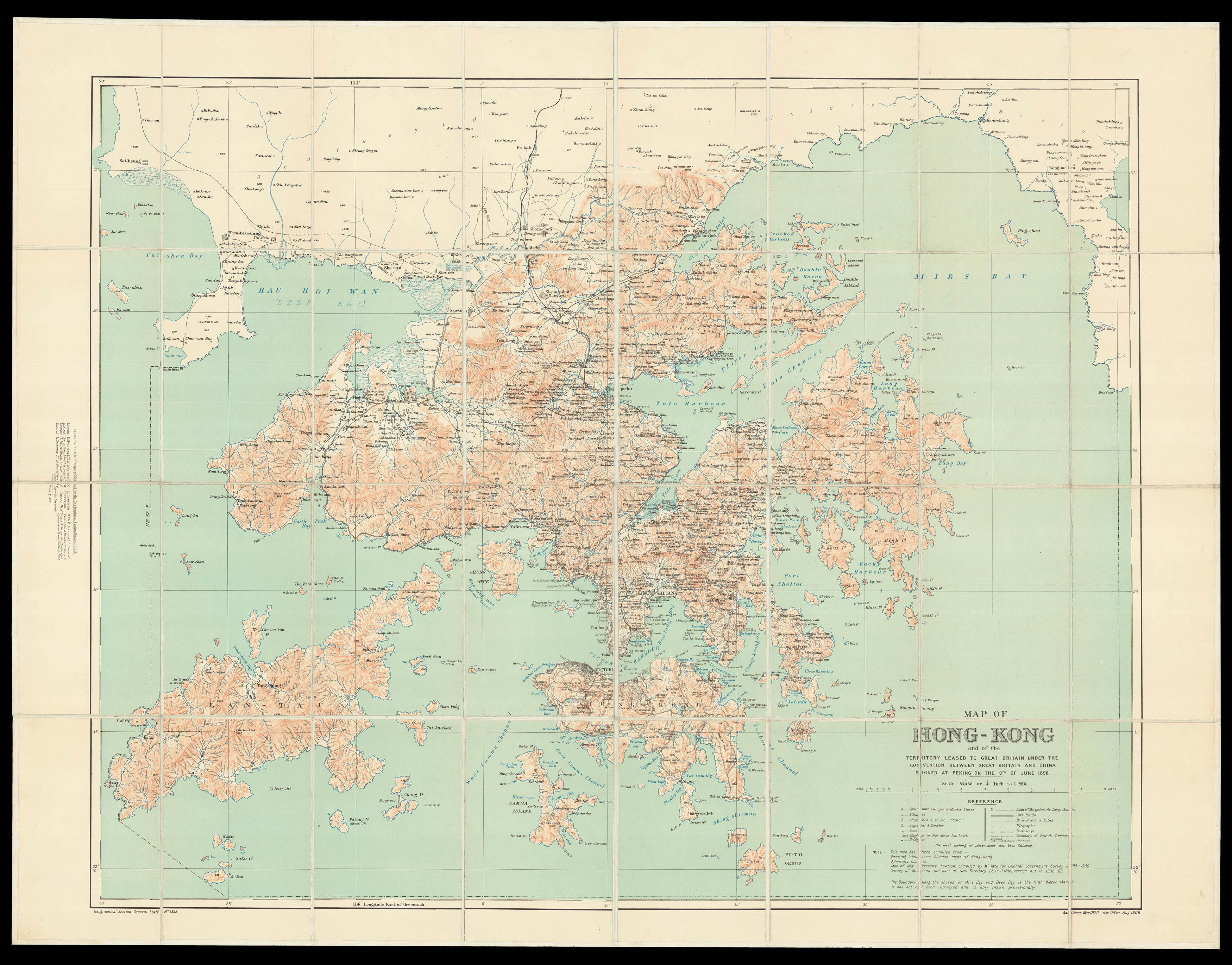
An early, attractive, and detailed map of Hong Kong and the New Territories first published in 1905 and re-issued with additions in 1922. The coastline from Sai Kung to Mirs Point onwards was taken from Admiralty charts; that of Deep Bay, from the mouth of the Sham Chun River to South-West Point, from a survey by the P.W.D.; thence northward and westward from Admiralty charts; that of Lan Tao and adjacent islands from a 1-inch map compiled by Tate; and the New Territories f...
An early, attractive, and detailed map of Hong Kong and the New Territories first published in 1905 and re-issued with additions in 1922. The coastline from Sai Kung to Mirs Point onwards was taken from Admiralty charts; that of Deep Bay, from the mouth of the Sham Chun River to South-West Point, from a survey by the P.W.D.; thence northward and westward from Admiralty charts; that of Lan Tao and adjacent islands from a 1-inch map compiled by Tate; and the New Territories from a map compiled by W. J. Newland in 1903-04, with additions and revisions by P.W.D. in 1913 and 1922.
As listed in the "Reference" table, the map shows "Important Villages & Market Places; Villages; Churches & Mission Stations; Pagodas & Temples; Pass; Heights in Feet above Sea Level; Bridges; Limit of Navigation for Large Junks; Cart Roads; Pack Roads & Paths; Telegraphs; Tramways; Boundary of British Territory; and Railways, the local spelling of place-names has been followed".
This map has been compiled from "Existing Intelligence Division maps of Hong Kong; Admiralty Charts; Map of New Territory Kowloon, compiled by Mr. Tate for Colonial Government Survey 1899 – 1900; Survey of Kowloon and part of New Territory (8 In. – 1 Mile) carried out in 1902-1903 - The boundary along the Shores of Mirs Bay and Deep Bay is the High Water Mark. It has not yet been surveyed and is only shown provisionally - Geographical Section General Staff No. 1393. Additions, Mar. 1922, War Office, Aug. 1905".