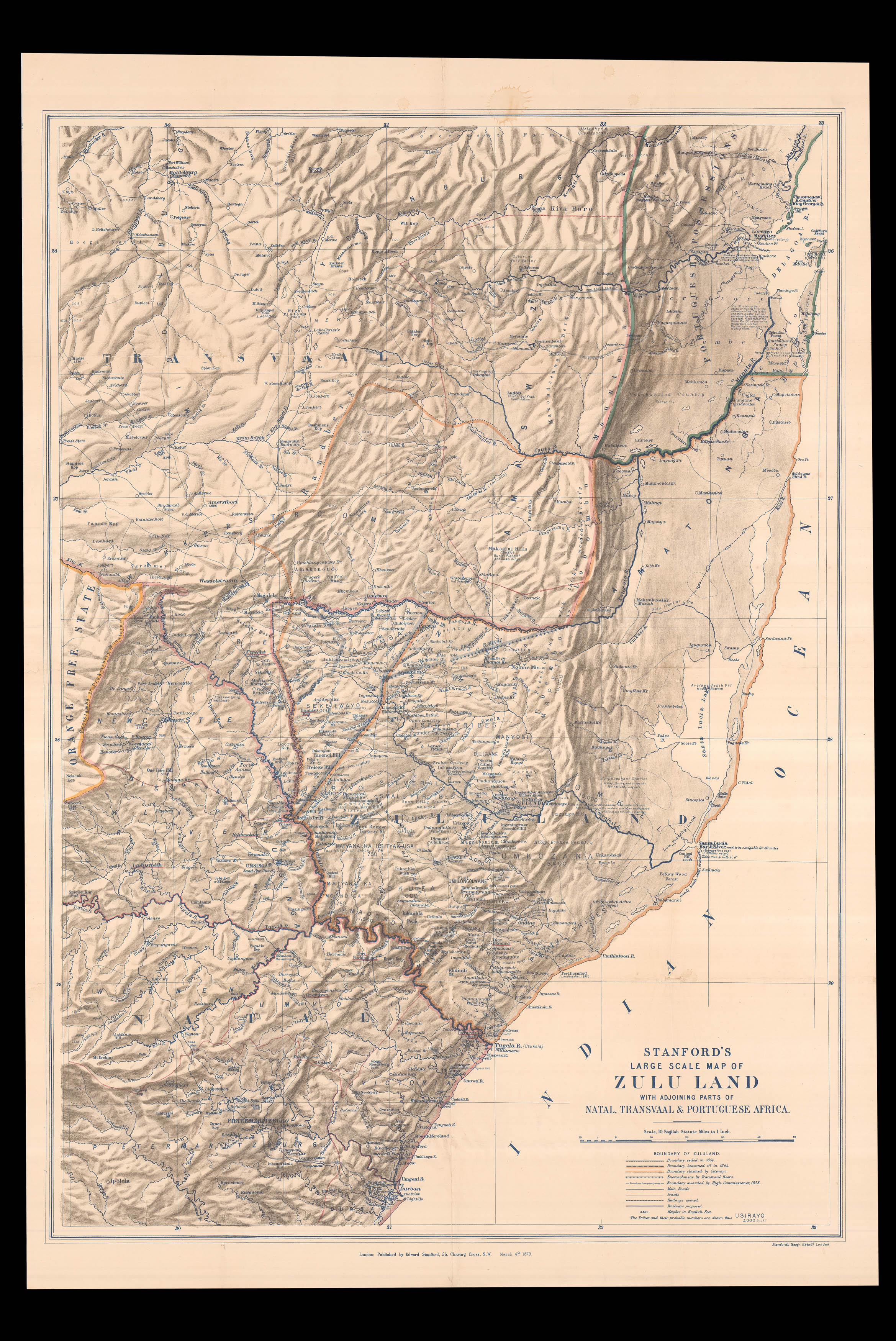
A map of Zululand published during the throes of the Anglo-Zulu war.
Showing territories within what is now South Africa, including the two British colonies Natal and Transvaal. The latter had been annexed by the British in 1877, which aggravated boundary disputes with King Cetshwayo of the neighbouring Zululand.
Rattled by the military might of the Zulus, the High Commissioner for Southern Africa demanded in 1878 that Cetshwayo accept a British reside...
A map of Zululand published during the throes of the Anglo-Zulu war.
Showing territories within what is now South Africa, including the two British colonies Natal and Transvaal. The latter had been annexed by the British in 1877, which aggravated boundary disputes with King Cetshwayo of the neighbouring Zululand.
Rattled by the military might of the Zulus, the High Commissioner for Southern Africa demanded in 1878 that Cetshwayo accept a British resident officer. This ultimatum, offered with neither the knowledge nor approval of the British Government, was deliberately inflammatory. When Cetshwayo ignored this threat, commander Lord Chelmsford (1827-1905) prepared to attack Zululand.
On January 21st 1879, the bulk of Chelmsford's force made camp in Isandlwana, leaving behind 80 engineers and 40 wounded men eleven miles away in a small outpost named Rorke's Drift. With somewhat tactless leadership, Chelmsford led two thirds of his men in the wrong direction, to fight a Zulu army he supposed were closer to Ulundi, the Zulu capital.
Shortly after he left camp on January 22nd, the 1,400 remaining soldiers were brutally slaughtered in a surprise attack by the Zulu forces. Corpses were left stripped of their uniform and ritually disembowelled. This Battle of Isandlwana was one of the greatest defeats ever suffered by the British against an indigenous force.
Running on the adrenaline of victory, approximately 4,000 Zulu warriors immediately marched to Rorke's Drift, where the small garrison of untrained and wounded soldiers huddled together against the assault. Outnumbered, inexperienced, and facing near certain defeat, the garrison fended off no fewer than six attacks until the Zulus abandoned the fight on January 23rd. The Zulus lost approximately 400-800 men; Rorke's Drift lost only 17. This remarkable feat later merited eleven Victoria Crosses and five Distinguished Conduct medals - making it the most awarded single battle in the history of the British Army.
Lord Chelmsford had missed both battles. In an effort to regain the reputation of his nation and his own station, he sent news to England in a call for heavy reinforcement. The message reached England by February 11th, and celebrated mapmaker Edward Stanford (1827-1904) wasted no time in updating his map of Zululand. Primarily, he corrected the location of Rorke's Drift from Natal to Zululand. He added "Camp Jan 22" at Isandlwana, here named 'Isandula', as well as a fortified camp at Eshowa ('Ekhowa').
Most excitingly, Stanford included- here in faint scribble - the military column led by Colonel Evelyn Wood (1838-1919). It was under Wood's command that the Zulus were defeated on March 29th in the Battle of Kambula, which became a turning point in the war - for the Zulu army was rendered too weak to withstand the second attack by Lord Chelmsford at the Battle of Ulundi. Cetshwayo was defeated on July 4th 1879, and Zululand subsequently divided into thirteen districts led by British-allied chiefs.
The present example demonstrates the haste at which Stanford worked to incorporate such fresh information. The erroneously-marked Rorke's Drift, along with Colonel Wood's position, are only partially erased, suggesting that Stanford was working under considerable time-pressure. These eager additions were swiftly re-corrected, as nine days later the British Library received a later state of this map: reference to Wood is completely eradicated, as well as the remnants of the previous location of Rorke's Drift. Moreover, crossed swords are inserted in the place of the date at Isandhlwana.
Stanford's speed exemplifies his skills as a cutting-edge cartographer, as the present example was published two months before the official military map by the Army's Intelligence Branch on May 21st 1879. Printed with the intention of wide circulation, it is possible Stanford's map would have been recognised by the 10,000 troops sent as reinforcement for Chelmsford's second attack - the final battle to end the Anglo-Zulu war.