A finely detailed chart of Curaçao, first published in Thomas Jefferys' 'West India Atlas' of 1775.
Geographer to King George III, Jefferys produced a large body of cartographical works throughout the eighteenth century and is particularly celebrated for his maps of North America and the Caribbean. His 'West India Atlas', published posthumously by Robert Sayer, was designed to aid Britain in the highly lucrative sugar trade, which by this point accounted for arou...
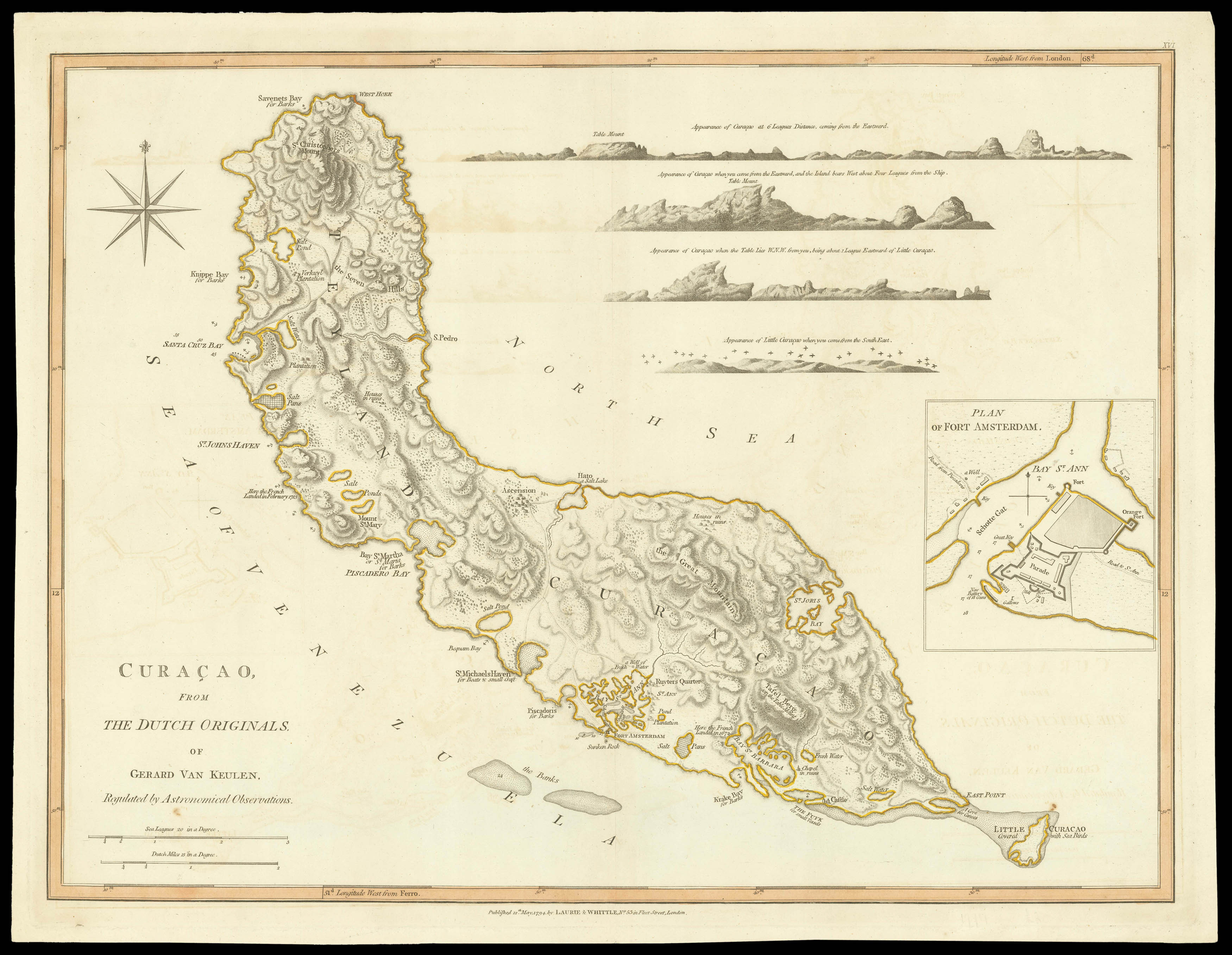
A finely detailed chart of Curaçao, first published in Thomas Jefferys' 'West India Atlas' of 1775.
Geographer to King George III, Jefferys produced a large body of cartographical works throughout the eighteenth century and is particularly celebrated for his maps of North America and the Caribbean. His 'West India Atlas', published posthumously by Robert Sayer, was designed to aid Britain in the highly lucrative sugar trade, which by this point accounted for around one-fifth of all imports to Europe, eighty percent of which was supplied by French and British colonies in the West Indies.
One exception, however, is the map of Curaçao, an island whose utility was not due to its sugar production, but rather the less palatable trade in slaves. Having been found by European colonists to be less amenable to agricultural development than many of its Caribbean neighbours, Curaçao instead became a hub for the transatlantic slave trade. Huge numbers of slaves were brought to the island from Africa, and sold on the docks of Willemstad, before travelling onwards to their final destinations. Indeed, the present chart was published just one year before a major slave revolt occurred in the island's Bandabou district.
Based on an earlier chart by the great Dutch cartography Gerard van Keulen, Jefferys' map depicts Curaçao's harbours, shoals and banks, plantations, salt pans, anchorages and vegetation; relief is shown by hachures, and depths by soundings. To the right is an inset plan of Fort Amsterdam, a compound constructed by the WIC in 1634 from which the larger capital of Willemstad later expanded. Although the toponym 'Willemstad', after William I of Orange, is first attested in the late seventeenth century, it does not appear on the chart, where only the fort, several illustrated houses and buildings, "Ruyter's Quarter", "a Well of Fresh Water" and "Pond Plantation" are shown around "Bay St. Ann". Other such details across the map include "Houses in ruins", "a Salt Lake", a castle and "A Cove for Canoes".
Strangely, a note next to "Bay St. Barbara" states that "Here the French Landed in 1672", despite their being no such incursion by the French onto the Dutch island that year. During the Franco-Dutch War of 1672-78, the French did have designs on the island, but no assaults were made with success. Jeffreys' note may perhaps mistakenly refer to the failed attempt by the governor of the French Antilles to invade Curaçao on March 13, 1673.
To the south-east of the main island, the small uninhabited island of "Little Curacao" is described as "Covered with Sea Birds". In the upper right-hand corner of the map are four coastal profiles of the islands as seen from the surrounding waters, the aforementioned sea birds illustrated on the last of these.
With its extensive maps, charts, plans and written description of the Caribbean, Jeffreys' 'West India Atlas' was evidently a commercial success. Within two decades of its initial publication, there were six subsequent editions by Sayer and, in 1794, an edition by prolific hydrographic publishers Laurie & Whittle, from which the present chart is taken.
bibliography:
bibliography:
cf NMM 366 pl. 103 for an example of the 1796 edition.