English engraver and cartographer Thomas Kitchin (1718-1784) began his
career as an apprentice to Emanuel Bowen, who later became his father- in-law. By the mid-eighteenth century Kitchin had established his own firm with premises first in Clerkenwell and then in Holborn. Throughout his career, he produced numerous cartographic works including both individual maps and larger atlases, and was made Hydrographer to King George II in 1773.
Among his earliest ...
English engraver and cartographer Thomas Kitchin (1718-1784) began his
career as an apprentice to Emanuel Bowen, who later became his father- in-law. By the mid-eighteenth century Kitchin had established his own firm with premises first in Clerkenwell and then in Holborn. Throughout his career, he produced numerous cartographic works including both individual maps and larger atlases, and was made Hydrographer to King George II in 1773.
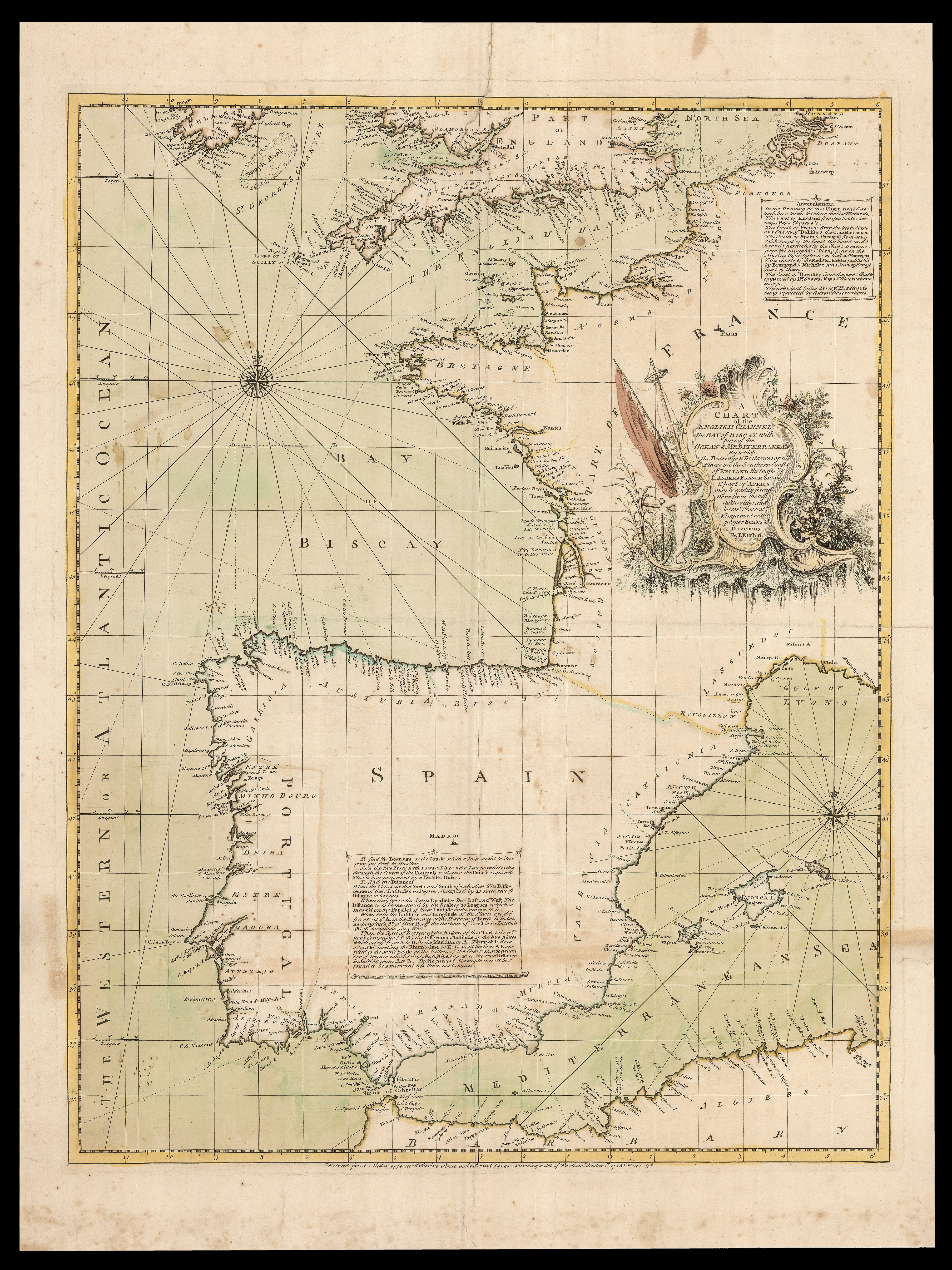
Among his earliest cartographic output is the present chart showing the waters of the English Channel, St George's Channel, the Bay of Biscay and the western Mediterranean. To the north and east of the Iberian Peninsula are two compass roses, with 32 lines spanning out from each to show the cardinal and intercardinal directions, as well as smaller divisions. Certain maritime obstacles such as banks and rocks are also identified, particularly in the English Channel. On the land, very many ports, harbours and cities are depicted along the British, Irish, French, Spanish, Portuguese, Dutch and North African coasts. The only places identified inland are the national capitals of London, Madrid and Paris.
There are two notes on the chart, that in the lower left-hand corner explaining how the chart could be used in navigation, particularly in calculating the distance between places, and that in the upper right-hand corner, naming the sources Kitchin had used to produce it:
"In the Drawing of this Chart great care has been taken to Collect the best Materials. The Coasts of England from particular Surveys, Maps, Charts &c. The Coast of France from the best Maps and Chart of Delisle & the C. de Maurepas. the Coasts of Spain & Portugal from the several surveys of the Coast Harbours and Islands particularly the Chart Drawn from the Drafts & Plans kept in the Marine Office by order of the C. de Maurepas & the charts of the Mediterranean publish'd by Bremond & Michelot who survey'd most part of them. The coast of Barbary from the same charts improved by Dr. Shaws Maps & Observations in 1739. The principal Cities Ports & Headlands being regulated by Astronl. Observations".
At this point in his career, Kitchin produced a number of European sea-charts; they were all published separately, and the present example offered for two pence, as stated at the end of the publisher's imprint. The chart was published by Andrew Millar, who Kitchin would collaborate with throughout his early; most famously in the publication of Mitchell's 'A Map of the British and French Dominions in North America', in 1755.
Unfortunately, Kitchin did not have great success with the charts, becoming far better known for his maps and atlases, and thus very few examples of this chart have survived.
Extremely rare: we are able to trace only two institutional examples, held by The British Library and Yale University Library.