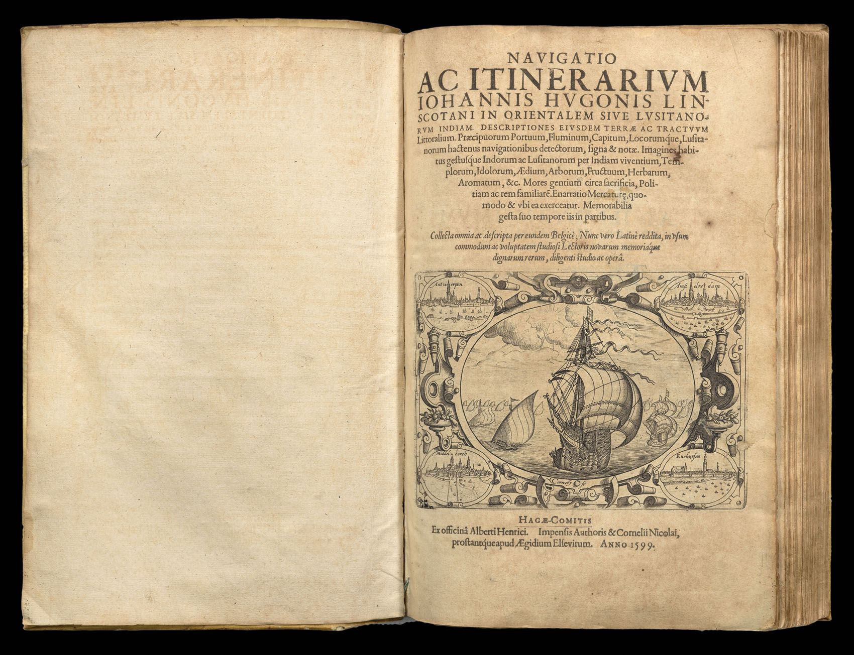
Navigatio ac itinerarium Johannis Hugonis Linscotani in orientalem sive lusitanorum Indiam
[WITH:] Descriptio totius Guineae Tractus Congi, Angolae [WITH:] Historia trium Navigationum Batavorum in Septentrionem [WITH:] Breviarium seu elenchus omnium redituum, Canonum, vecti-galium..
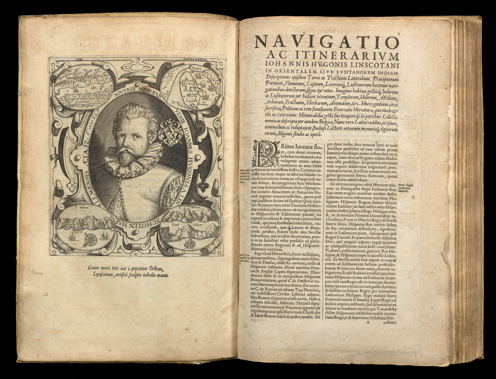
4 parts in 1 vol., First Latin Edition. engraved title, 42 engraved maps and plates, plus portrait of Linschoten on verso of preface, text leaves somewhat browned, superb impressions of maps, Maps of East Africa, and plate of nuptials in Goa with small rust holes, original limp vellum, title in ink to flat spine.
One of the most important of all travel books, Linschoten's was the first printed work to include precise sailing instructions for the East Indies. Its exposition of a route to the south of Sumatra through the Sunda Strait allowed Dutch and, later, English merchants to circumvent the Portuguese stranglehold on passage, and, therefore, trade, to the East through the Straits of Malacca. This enabled the British East India Company and the Dutch East India Company to set sail f...
One of the most important of all travel books, Linschoten's was the first printed work to include precise sailing instructions for the East Indies. Its exposition of a route to the south of Sumatra through the Sunda Strait allowed Dutch and, later, English merchants to circumvent the Portuguese stranglehold on passage, and, therefore, trade, to the East through the Straits of Malacca. This enabled the British East India Company and the Dutch East India Company to set sail for the Spice Islands and, ultimately, China and Japan, and was of such economic utility that, according to Church, and others, "it was given to each ship sailing from Holland to India" and soon became "the navigator's vade mecum for the Eastern seas" (Penrose).
Jan Huyghen van Linschoten (1563–1611) left the Netherlands for Spain in 1576 and, with the assistance of his brother, Willem, secured passage to India in 1583 as secretary to Dominican Vicente da Fonseca, the newly-appointed Portuguese Archbishop of Goa. As a result of his position, Jan Huyghen had access to secret information, including the Portolan charts relating to the East Indies that had been well guarded for over a century. With an impressive disregard for the trust placed in him, Linschoten began to copy these maps meticulously, displaying an "avaricious thirst for knowledge which enabled him to get detailed information of land and sea as far afield as the Spice Islands and China" (Penrose). With the death of the Archbishop in 1589, Linschoten was obliged to set sail for Lisbon, but was delayed for two years in the Azores by a shipwreck following an attack by English pirates. He landed in Lisbon in 1592 and shortly thereafter traveled back to his home at Enkhuizen.
In June 1594, Linschoten sailed from Texel on the first of two unsuccessful expeditions in search of a Northeast passage via the Kara Sea led by Dutch cartographer Willem Barentsz.
In 1595, with the support of the Amsterdam publisher, Cornelis Claesz, Linschoten began to record his travels in the three books contained within the present volume which Parry calls "a journal of human adventure and observation, [and] an uplifting story that appeals on many levels."
The first book deals with the East Indies and East Africa, including regions as far east as Japan. Klooster describes the work as "a magnificent panorama of pictures and maps of the non-European world … [that] contained so much detailed and accurate information about shipping lanes, winds, and currents, that seafarers could use it virtually as a handbook". The work is also especially valuable for its eyewitness account of India, termed by Lach "the most important of the firsthand accounts published independently of the great travel collections". He further states that Linschoten's description of Goa is "one of the most original and reliable narratives prepared during the sixteenth century on life at the hub of Portugal's Eastern empire and still is regarded as one of the best sources for Goa's history at the peak of its glory … [The] maps, which are much better and more detailed than earlier printed maps, were clearly derived from the latest and best Portuguese charts of the Eastern oceans and sea coasts".
The second book describes the navigation of the coasts of West Africa around the Cape of Good Hope to Arabia, together with the coasts of the New World. It includes a real 'roteiro' after the Portuguese Royal pilot Diego Alfonso, containing sailing directions from Portugal to India, and instructions for sailing from island to island in the East Indies.
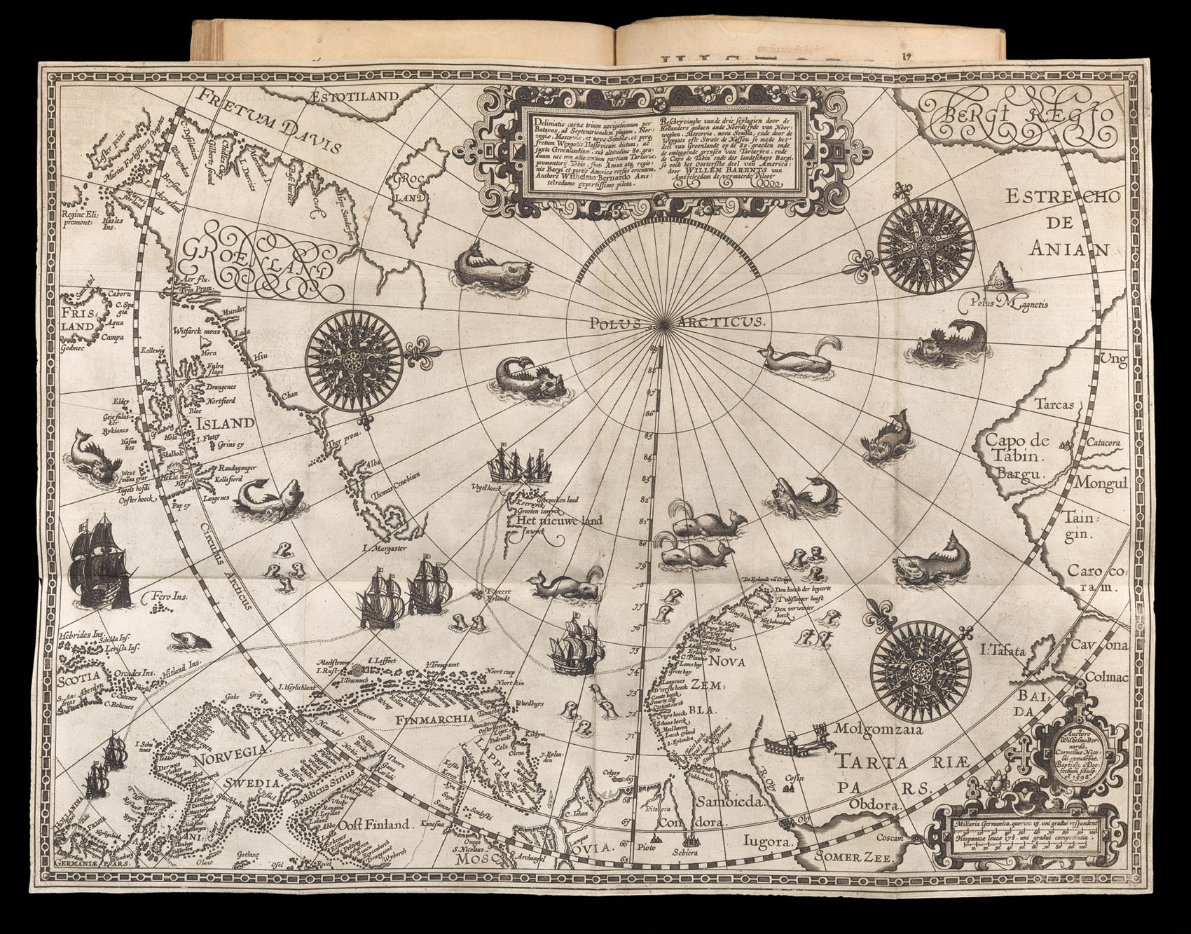
The third book covers Barentsz' three arctic voyages. During the late sixteenth century, the leading merchants of the Dutch Republic became very interested in opening trade routes with East Asia. Yet, they were deeply concerned that the established route to Asia, by way of the Cape of Good Hope and the Indian Ocean, was under the control of the Portuguese, who were enemies of the Dutch. Moreover, the established route was very long, and it was thought that any navigable polar route to Asia would be more expeditious. While exploring the Northwest Passage via the North American Arctic was considered, the failure of Martin Frobisher and John Davis's various attempts to find such a route in the 1570s and '80s discouraged any efforts in this direction. In 1553-54, the English adventurers Sir Hugh Willoughby and Richard Chancellor attempted to find a Northeast Passage to Asia, over Siberia, and while their mission ultimately failed in this regard, their progress and the nature of their reports convinced many in Amsterdam that such a passage could quite plausibly be opened, given another attempt. This torch was to be carried by Willem Barentsz.
Willem Barentsz (c. 1550-1597) was a Dutch map maker and explorer and one of the great pioneers of Arctic exploration. His first major work was an atlas of the Mediterranean, which he co-published with Petrus Plancius. Barentsz believed that the North Polar regions included a northeastern passage to the Pacific and that the Polar regions consisted of open waters above Siberia, due to the fact that they would be exposed to the sun 24 hours per day. In the last decade of the sixteenth Century, Barentsz made 3 voyages to the North Polar regions. In June 1594, Barentsz led an expedition of 3 ships which sailed from Texel for the Kara Sea. On this voyage, the crew made the first ever encounter with a polar bear. Barentsz's first voyage reached the west coast of Novaya Zemlya. After coasting northward, the crew encountered large icebergs and were forced to turn back and return to Holland.
In 1595, Prince Maurice of Orange commissioned a second expedition led by Barentsz, which included 6 ships and a cargo of goods which were intended for trade with China. The expedition made several noteworthy encounters with Samoyed "wilde men" and polar bears, but was forced to turn back when they encountered a frozen Kara Sea.
In 1596, the Town Council of Amsterdam sponsored a voyage of two ships, in hopes of claiming a reward offered by the Dutch States-General, to the first expedition that navigated the northeast passage. Barentsz voyage discovered Spitsbergen, before reaching Bear Island on July 1, 1596 and Novaya Zembla on July 17, 1596. Shortly thereafter, Barentsz's ship was stranded by ice and the 16 man crew was forced to winter on the ice. After making it through the winter, the crew set out in two small boats on June 13, with Barentsz dying about 7 days later. Seven weeks later, the remainder of the crew reached Kola and were rescued by a Russian Merchant ship. The crew made it back to Amsterdam in November 1597, and several crew members wrote accounts of the voyage.
The wooden lodge where Barentsz's crew spent the winter was not revisited until 1871, when it was discovered by the Norwegian seal hunter Elling Carlsen. In 1875, Captain Gunderson returned to the site and collected several artifacts, including 2 maps and a handwritten translation of the Pet and Jackman voyages. In 1876, Charles L.W. Gardiner visited the site and collected many more artifacts and documents, including Barentsz's and Jacob van Heemskerck's notes on the settlement.
The map was originally published as a separately issued map, and several surviving copies can be found bound into composite atlases of the period. The map was also included in some copies of Linschoten's Navigatio ac itinerarium, as per the present example.
While Barentz's attempts to find the Northest Passage were untlimately not successful, his bravery and intellectual curiousity inspired future generations of Polar explorers. His magnifient map was thus foundation on which all further oriental Arctic exploration was predicated, making it one of the most consequential maps of its era.
The map shows a sophisticated understanding of the Polar coasts of Europe as far east as Novaya Zemlya (meaning "New World" in Russian, the furthest point of Barentsz's voyage). The mapping of the east coast of Novaya Zemlya is very comprehensive and features dozens of placenames. The coasts of Asia, further to the east are speculative, and beyond that lies the apocryphal Strait of Anian, supposedly the gateway from the Arctic to the Pacific Ocean. In the west, Greenland and Iceland are well defined, although the mythical island of 'Frisland' (Friesland) is still placed in the Northwest Atlantic. To the south and west of Greenland are the straits and the parts of Baffin Island recently discovered by Martin Frobisher and John Davis. Further north is the mythical "Estotiland", which originated from an apocryphal 14th Century Venetian voyage by the brothers Zeno.
Barentsz's map contains 34 illustrations of sea monsters, ships and whales, and an island named "Polus Magnetis." The first edition of the map is extremely rare. Among other important firsts, the map is the first to depict Spitsbergen, shown as "Het Nieuwe Land" above Finmarchia, discovered by Barentsz in 1596.
The fourth book gives an account of America and the African coast.
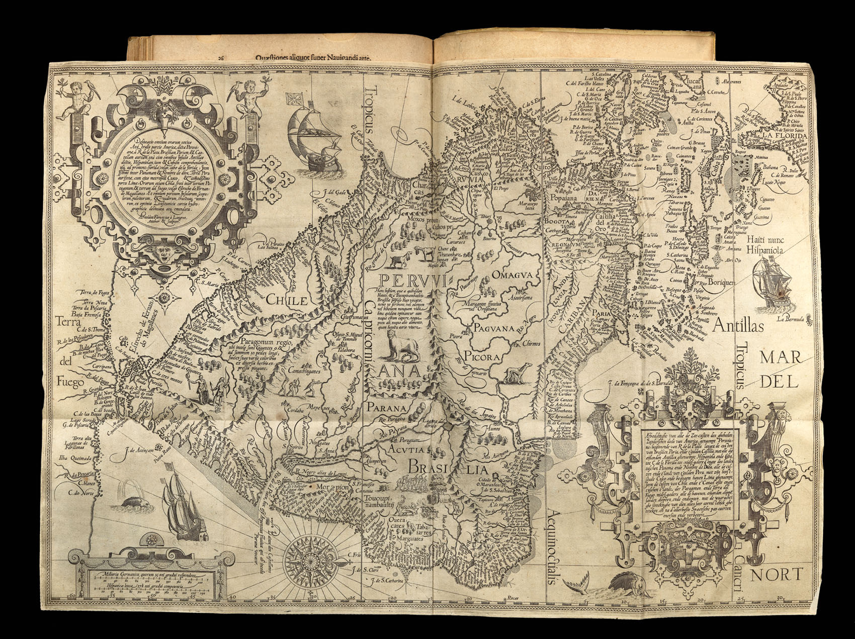
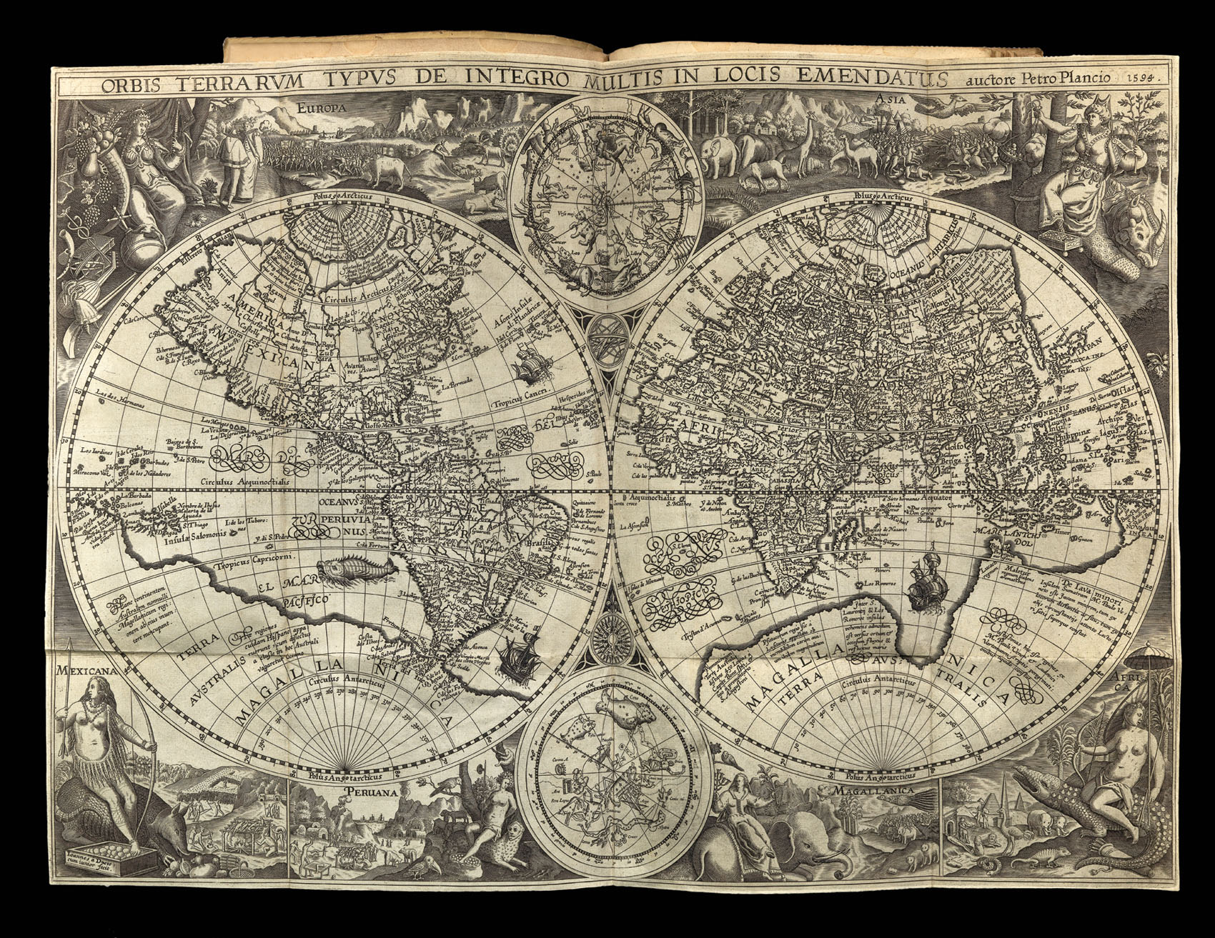
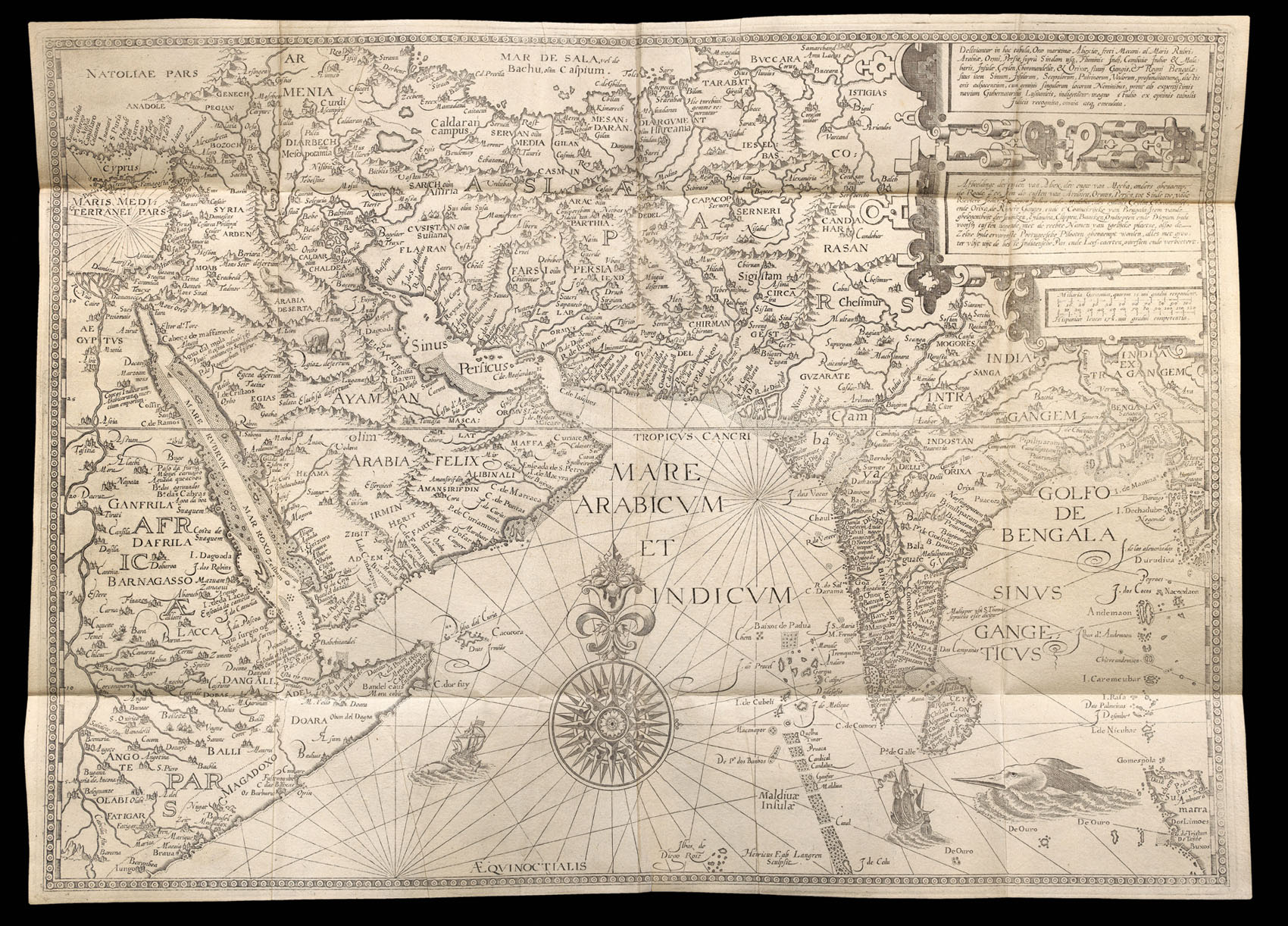
Linschoten's travels are also of importance as one of the few Renaissance works on the East to be illustrated from life, with plates depicting the people, manners, and products of Asia (particularly Java, China, and India) engraved after drawings by the author. Its many large and folded maps include van Langren's maps of the East Indies and South America (including the Caribbean and Florida), and the double-hemispherical world map of Plancius (Shirley 187), and are, according to Klooster, based upon the manuscript portolans of Fernão Vaz Dourado (c.1520–c.1580) and Lach considers them "the last important depiction of Asia to be produced for general distribution in the sixteenth century".
"Fine copies of this work with all the maps and plates are extremely rare" (Church).
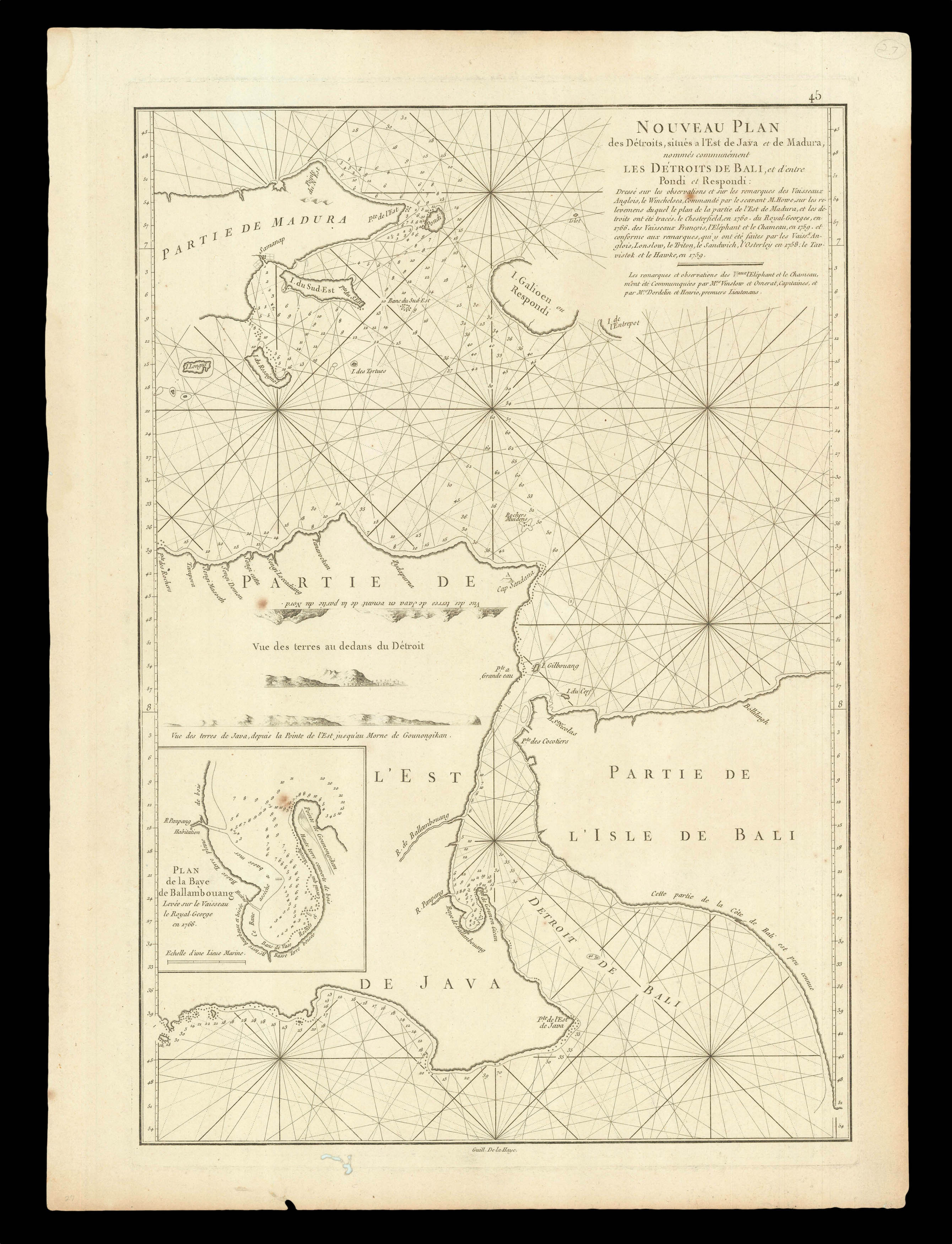 The Bali Strait
1 × £300
The Bali Strait
1 × £300