Arguably one of the most beautiful early maps of South America.
It displays the area at the approximate high water mark of the Spanish Empire in the New World. It was the only map of the Americas in Linschoten's Itinerarium, the work that is credited for enabling the Dutch entry into the lucrative East Indies and Brazilian trade, once the exclusive preserves of the Portuguese. This ornately engraved work adopted the style of the Portuguese portolan chart on whic...
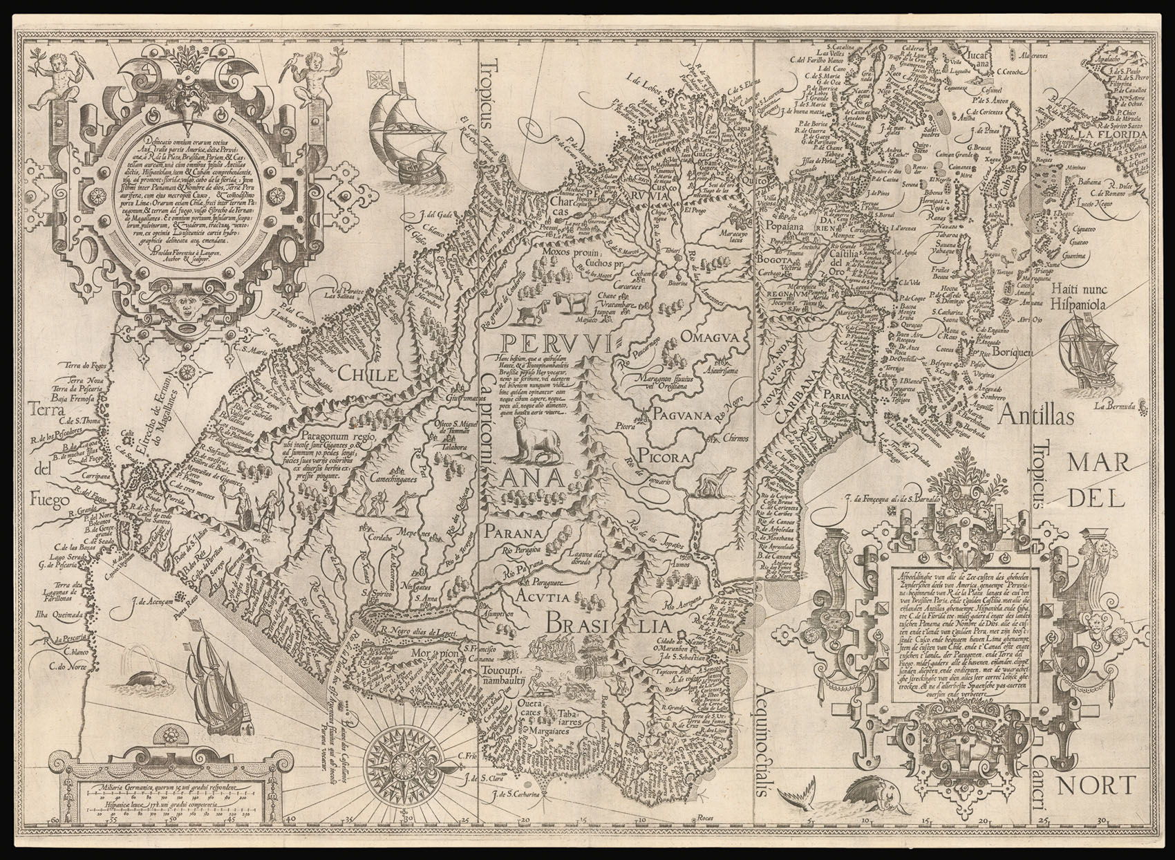
Arguably one of the most beautiful early maps of South America.
It displays the area at the approximate high water mark of the Spanish Empire in the New World. It was the only map of the Americas in Linschoten's Itinerarium, the work that is credited for enabling the Dutch entry into the lucrative East Indies and Brazilian trade, once the exclusive preserves of the Portuguese. This ornately engraved work adopted the style of the Portuguese portolan chart on which it was based. Its vignettes illustrate many of the legends associated with South America, such as the giants of Patagonia.
Jan Huyghen van Linschoten (1563–1611) left the Netherlands for Spain in 1576 and, with the assistance of his brother, Willem, secured passage to India in 1583 as secretary to Dominican Vicente da Fonseca, the newly-appointed Portuguese Archbishop of Goa. As a result of his position, Jan Huyghen had access to secret information, including the Portolan charts relating to the East Indies that had been well guarded for over a century. With an impressive disregard for the trust placed in him, Linschoten began to copy these maps meticulously, displaying an "avaricious thirst for knowledge which enabled him to get detailed information of land and sea as far afield as the Spice Islands and China" (Penrose). With the death of the Archbishop in 1589, Linschoten was obliged to set sail for Lisbon, but was delayed for two years in the Azores by a shipwreck following an attack by English pirates. He landed in Lisbon in 1592 and shortly thereafter travelled back to his home at Enkhuizen.
In June 1594, Linschoten sailed from Texel on the first of two unsuccessful expeditions in search of a Northeast passage via the Kara Sea led by Dutch cartographer Willem Barentsz.
In 1595, with the support of the Amsterdam publisher, Cornelis Claesz, Linschoten began to record his travels in the three books which Parry calls "a journal of human adventure and observation, [and] an uplifting story that appeals on many levels."
The first book deals with the East Indies and East Africa, including regions as far east as Japan. Klooster describes the work as "a magnificent panorama of pictures and maps of the non-European world … [that] contained so much detailed and accurate information about shipping lanes, winds, and currents, that seafarers could use it virtually as a handbook". The work is also especially valuable for its eyewitness account of India, termed by Lach "the most important of the firsthand accounts published independently of the great travel collections". He further states that Linschoten's description of Goa is "one of the most original and reliable narratives prepared during the sixteenth century on life at the hub of Portugal's Eastern empire and still is regarded as one of the best sources for Goa's history at the peak of its glory … [The] maps, which are much better and more detailed than earlier printed maps, were clearly derived from the latest and best Portuguese charts of the Eastern oceans and sea coasts".
The second book was originally published in 1595: a year before the 'first' book of this volume. It describes the navigation of the coasts of West Africa around the Cape of Good Hope to Arabia, together with the coasts of the New World. It includes a real 'roteiro' after the Portuguese Royal pilot Diego Alfonso, containing sailing directions from Portugal to India, and instructions for sailing from island to island in the East Indies.
The third book, gives an account of America and the African coast.
Linschoten's travels are also of importance as one of the few Renaissance works on the East to be illustrated from life, with plates depicting the people, manners, and products of Asia (particularly Java, China, and India) engraved after drawings by the author. Its many large and folded maps include van Langren's maps of the East Indies and South America (including the Caribbean and Florida), and the double-hemispherical world map of Plancius (Shirley 187), and are, according to Klooster, based upon the manuscript portolans of Fernão Vaz Dourado (c.1520–c.1580) and Lach considers them "the last important depiction of Asia to be produced for general distribution in the sixteenth century".