This map shows an area of northern Africa from Egypt to Libya. The Nile Valley and Delta is shown in some detail. The Red Sea ('Sinus Arabicus') appears to the east.
Map from the beautiful second Rome edition of Ptolemy's Geographia. "This handsome edition is a reprinting of the copper-plate maps of the 1478 Ptolemy [the first Rome edition by Conrad Sweynheym and Arnold Buckinck, whose] maps are considered the finest Ptolemaic ones produced up to the time that th...
This map shows an area of northern Africa from Egypt to Libya. The Nile Valley and Delta is shown in some detail. The Red Sea ('Sinus Arabicus') appears to the east.
Map from the beautiful second Rome edition of Ptolemy's Geographia. "This handsome edition is a reprinting of the copper-plate maps of the 1478 Ptolemy [the first Rome edition by Conrad Sweynheym and Arnold Buckinck, whose] maps are considered the finest Ptolemaic ones produced up to the time that the great Mercator engraved his Ptolemy of 1578... It is believed that Sweynheym was the one who first thought of applying the very new art of copper-engraving to the printing of maps, and he might have taken a hand in the actual engraving of them himself" (World Encompassed). While the Bologna edition of 1477 was the first atlas to use copperplate maps, the present series is generally regarded as superior for its clear captions, accurate projections and overall design. Also, there are indications the Bologna edition was hurried through the press: the captions were not engraved but stamped into the plates. The early Italian Ptolemys, particularly the Rome editions, are "superb testimonials of Italian craftsmanship without the picturesque but unscientific monsters of the medieval maps or the addition of the adventitious decoration of later work, relying for their beauty solely on the delicacy of their execution and the fineness of the material employed" (Tooley).
bibliography:
bibliography:
BMC IV, 133; BSB-Ink P-861; Goff P-1086; HC 13541; Nordernskiöld 7; Sabin 66474; Shirley 4; The World Encompassed 40.
![HEYWOOD, Captain P[eter] The Typa and Harbour of Macao.](https://omega.crouchrarebooks.com/wp-content/uploads/2025/03/22648_1H.jpg) Captain Heywood's chart of Macau
1 × £9,000
Captain Heywood's chart of Macau
1 × £9,000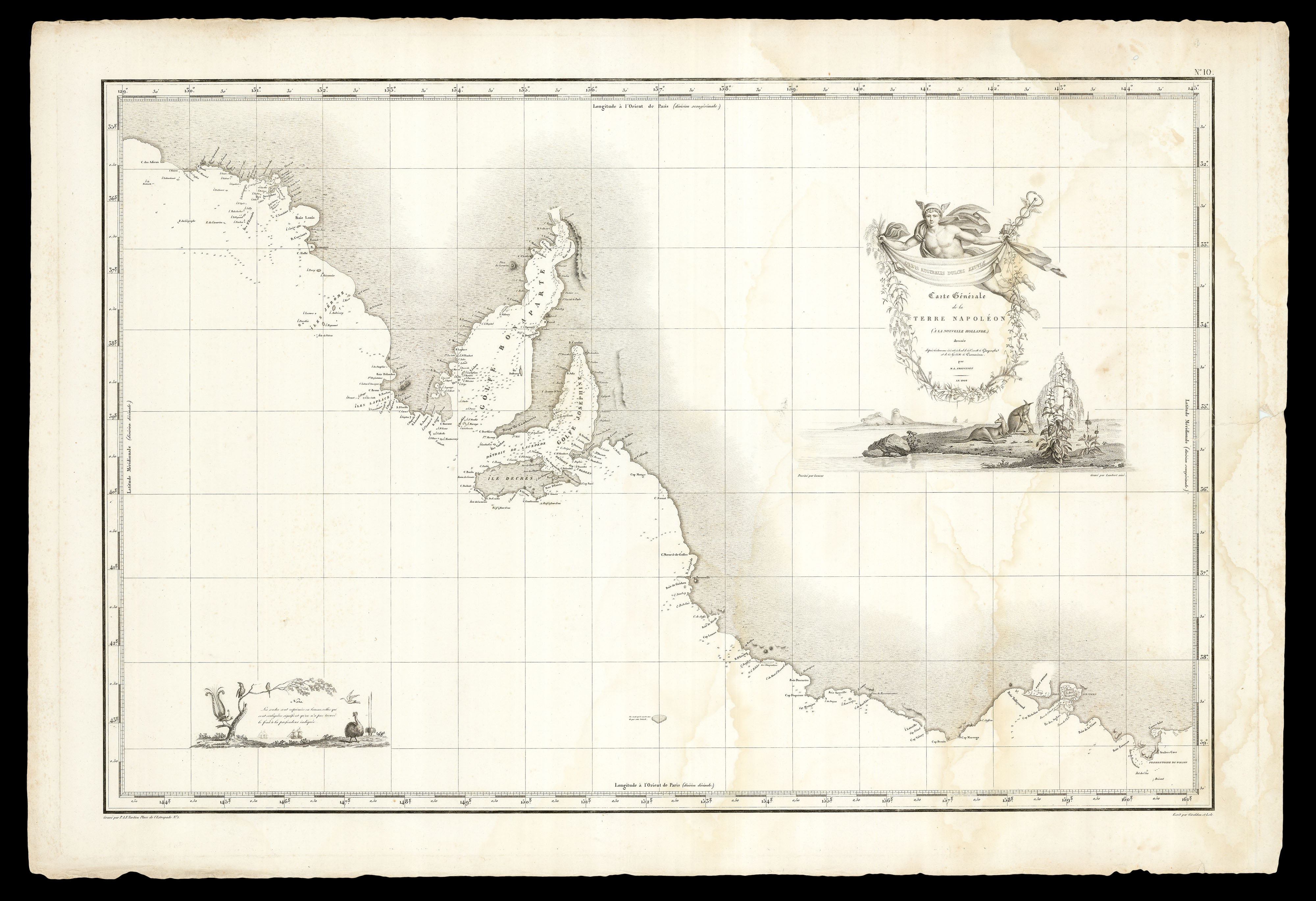 Near Adelaide
1 × £2,000
Near Adelaide
1 × £2,000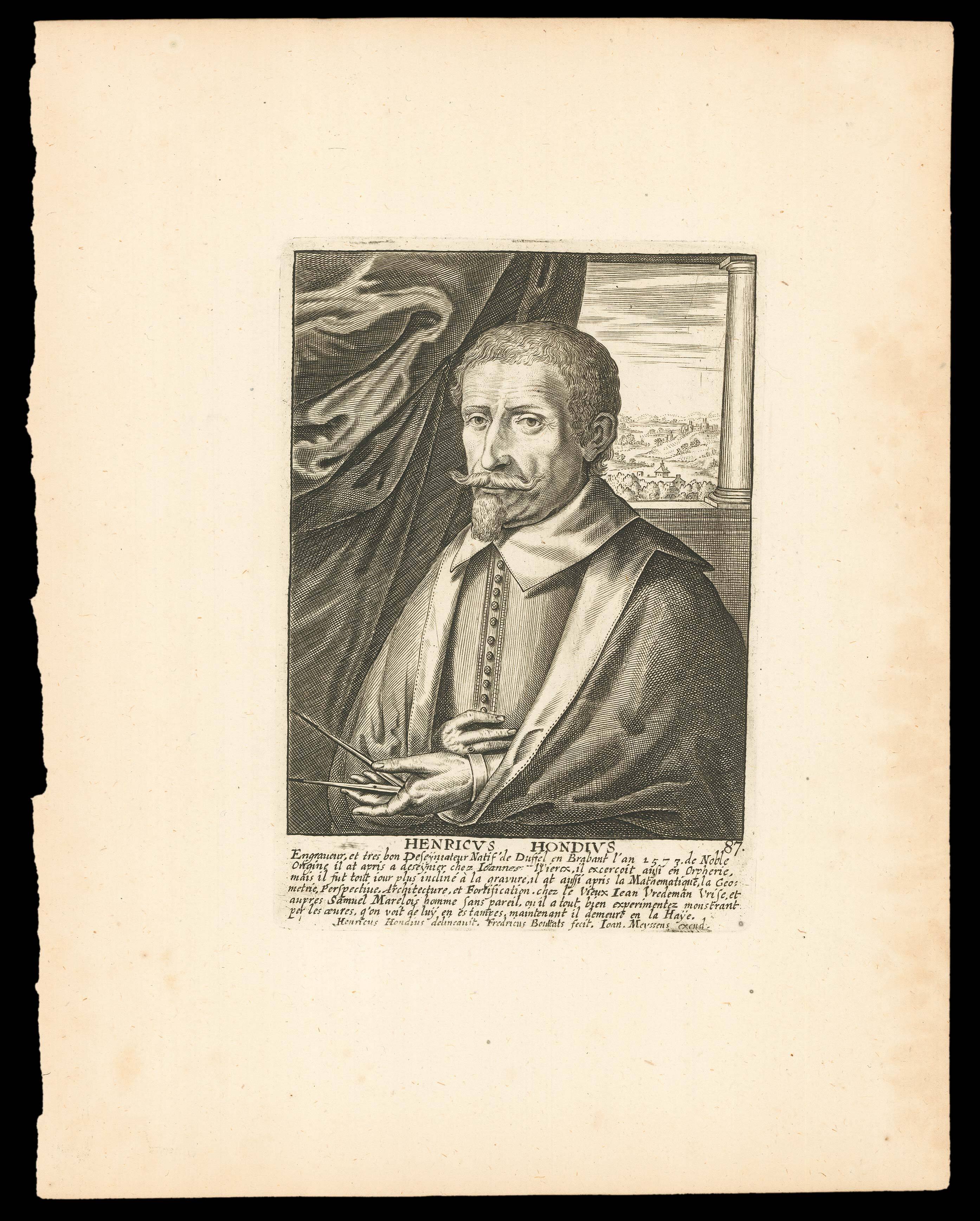 Hendrik Hondius
1 × £200
Hendrik Hondius
1 × £200![GOODALL, Cha[rle]s Goodall's Victorian Playing Cards](https://omega.crouchrarebooks.com/wp-content/uploads/2025/03/20698_1H.jpg) Diamond Jubilee Cards
1 × £400
Diamond Jubilee Cards
1 × £400 From the first edition of 'Hakluytus Posthumus'
1 × £150
From the first edition of 'Hakluytus Posthumus'
1 × £150![BAKER, W[illiam] E[merson]. This Porcineograph.](https://omega.crouchrarebooks.com/wp-content/uploads/2025/03/15815_1H.jpg) America Hams it Up
1 × £12,000
America Hams it Up
1 × £12,000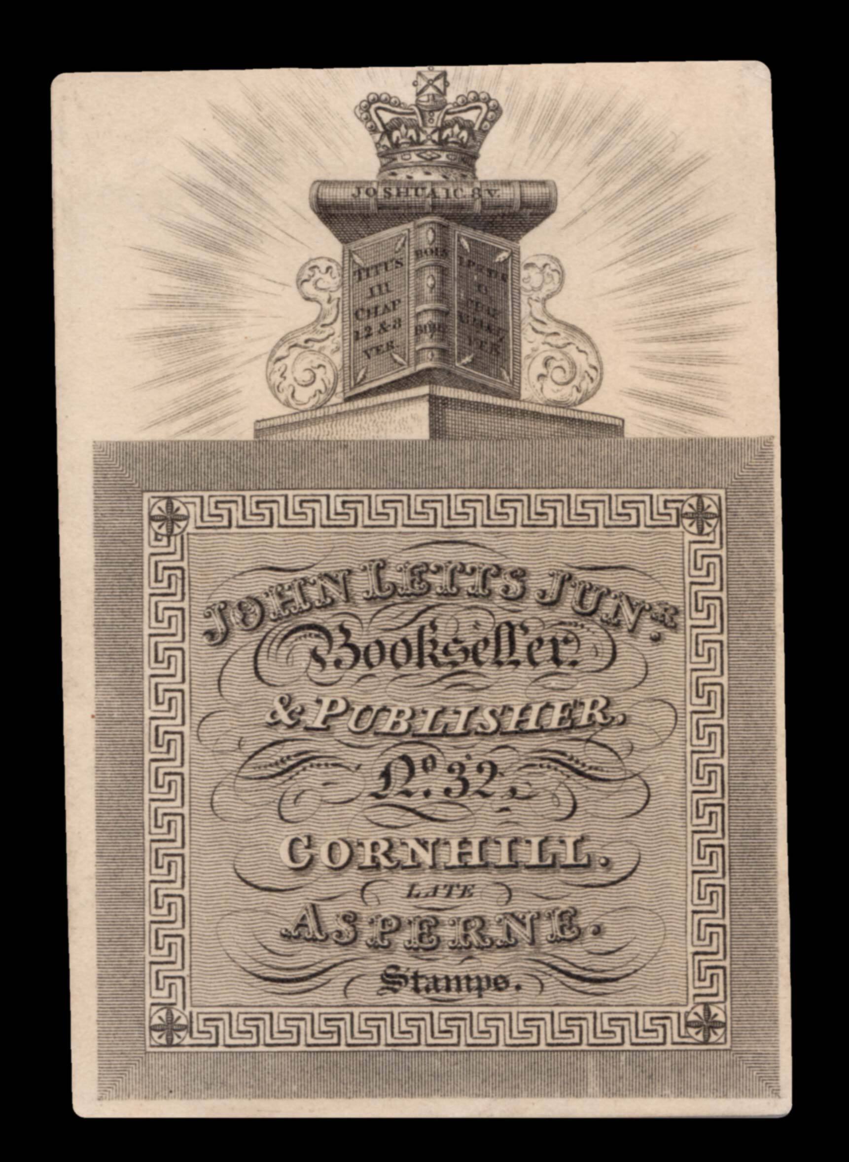 Trade card for Letts's 'Diary', recording the arrival and departure of ships into the Port of London
1 × £400
Trade card for Letts's 'Diary', recording the arrival and departure of ships into the Port of London
1 × £400![[ANDREES, Richard] Japan.](https://omega.crouchrarebooks.com/wp-content/uploads/2025/03/15809_1H.jpg) From the fourth edition of 'Andrees Allgemeiner Handatlas
1 × £40
From the fourth edition of 'Andrees Allgemeiner Handatlas
1 × £40![SHERMIN, W[illiam] and WHITE, T[homas] after MALTON, T[homas] The College of Arms, or Heralds Office, London, MDCCLXVIII.](https://omega.crouchrarebooks.com/wp-content/uploads/2025/03/12441_1H.jpg) The College of Arms
1 × £2,000
The College of Arms
1 × £2,000![[Anonymous] Londres.](https://omega.crouchrarebooks.com/wp-content/uploads/2025/03/12363_1H.jpg) A French variant of De Jonghe's view of London
1 × £2,400
A French variant of De Jonghe's view of London
1 × £2,400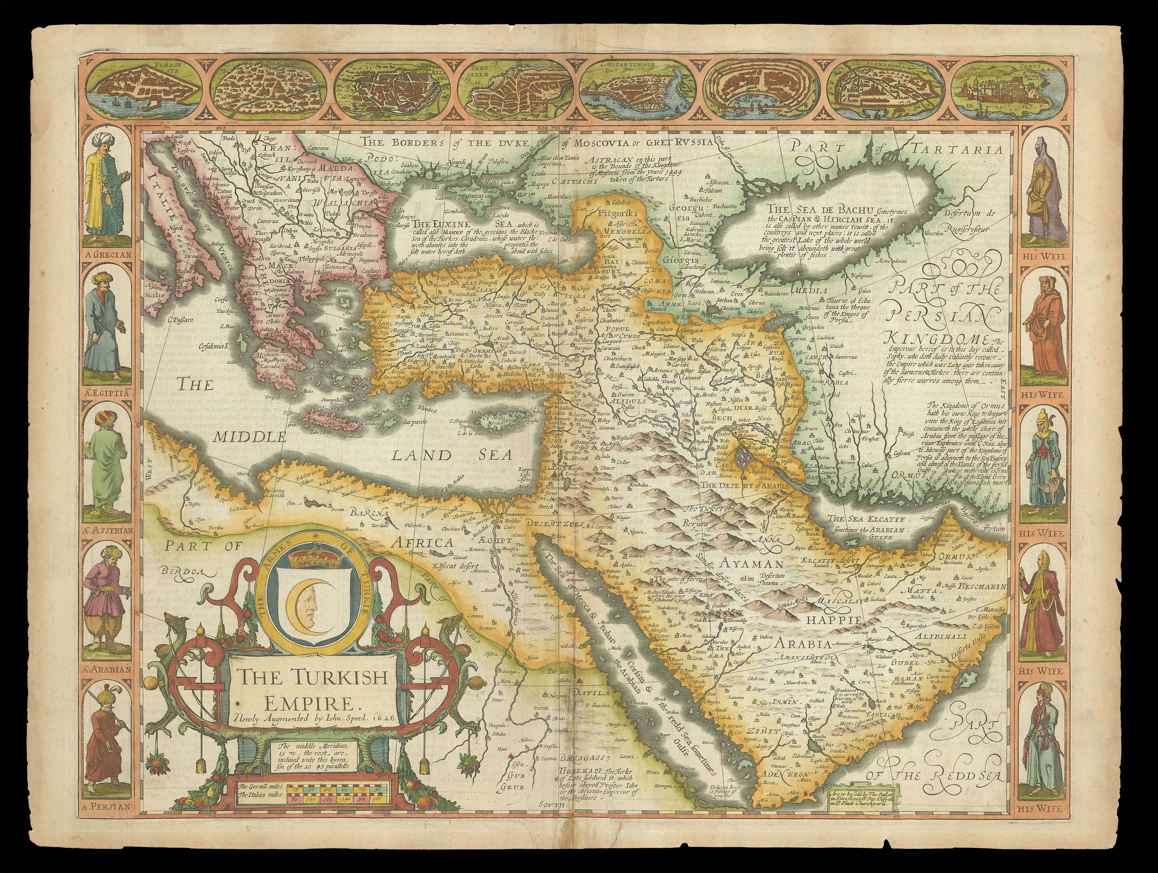 Speed's map of the Ottoman Empire
1 × £2,000
Speed's map of the Ottoman Empire
1 × £2,000![TAVERNIER, Jean-Baptiste [and] TAVERNIER, Daniel Carte Faite sur les Lieux par Daniel Tavernier en Plusieurs...](https://omega.crouchrarebooks.com/wp-content/uploads/2025/03/20577_1H.jpg) One of the earliest maps of Vietnam
1 × £3,000
One of the earliest maps of Vietnam
1 × £3,000![DE JODE, Cornelis Novae Guineae Formus and Situs; Quivirae Regnu[m], cum alijs versus Borea[lem]](https://omega.crouchrarebooks.com/wp-content/uploads/2025/03/21877_1H.jpg) The first printed map of Alaska and the first map to focus on "Australia"
1 × £18,000
The first printed map of Alaska and the first map to focus on "Australia"
1 × £18,000![REMONDINI PRESS [30] [Arte Povera?]](https://omega.crouchrarebooks.com/wp-content/uploads/2025/03/3084_1H.jpg) Remondini binding papers
1 × £1,200
Remondini binding papers
1 × £1,200![[BRY, Theodor de; after] J. Hugo v. Linchoten geb. zu Harlem im J. 1563.](https://omega.crouchrarebooks.com/wp-content/uploads/2025/03/17743_1H.jpg) Jan Huyghen van Linschoten
1 × £200
Jan Huyghen van Linschoten
1 × £200![[ANONYMOUS] Jeu des Drapeaux](https://omega.crouchrarebooks.com/wp-content/uploads/2025/03/21534_1H.jpg) Napoleon returns from exile
1 × £5,000
Napoleon returns from exile
1 × £5,000![SPILSBURY, J[ohn] Asia in its Principal Divisions, By J. Spilsbury, 1767.](https://omega.crouchrarebooks.com/wp-content/uploads/2025/03/17653_1H.jpg) Rare undissected jigsaw map of Asia
1 × £5,000
Rare undissected jigsaw map of Asia
1 × £5,000 F is for Framer
1 × £550
F is for Framer
1 × £550![NIELS, Theodoor; SAVERIJ, Salomon [engraved figures after] VENNE, Adriaan van de; BERCKENRODE, Balthasar Florensz van [engraved map] Expugnatio Sylvae-Ducis Ao 1629.](https://omega.crouchrarebooks.com/wp-content/uploads/2025/03/14959_1H.jpg) The Siege of the Swamp Dragon
1 × £90,000
The Siege of the Swamp Dragon
1 × £90,000![BLAEU, Johannes [II] [Chart of the West Coast of Saudi Arabia and the Red Sea].](https://omega.crouchrarebooks.com/wp-content/uploads/2025/03/16247_1H.jpg) A Dutch East India Company (VOC) manuscript chart fragment of the Arabian Coast and Red Sea signed and dated by Joan Blaeu II
1 × £90,000
A Dutch East India Company (VOC) manuscript chart fragment of the Arabian Coast and Red Sea signed and dated by Joan Blaeu II
1 × £90,000![HAUTTECOURT, Frederick de [Untitled Chart of 'White Sand Bay', Cornwall].](https://omega.crouchrarebooks.com/wp-content/uploads/2025/03/11347_1H.jpg) White Sand Bay Cornwall
1 × £1,600
White Sand Bay Cornwall
1 × £1,600


![[PTOLEMAEUS, Claudius] Tertia Africae Tabula](https://omega.crouchrarebooks.com/wp-content/uploads/2025/03/12977_1H.jpg)