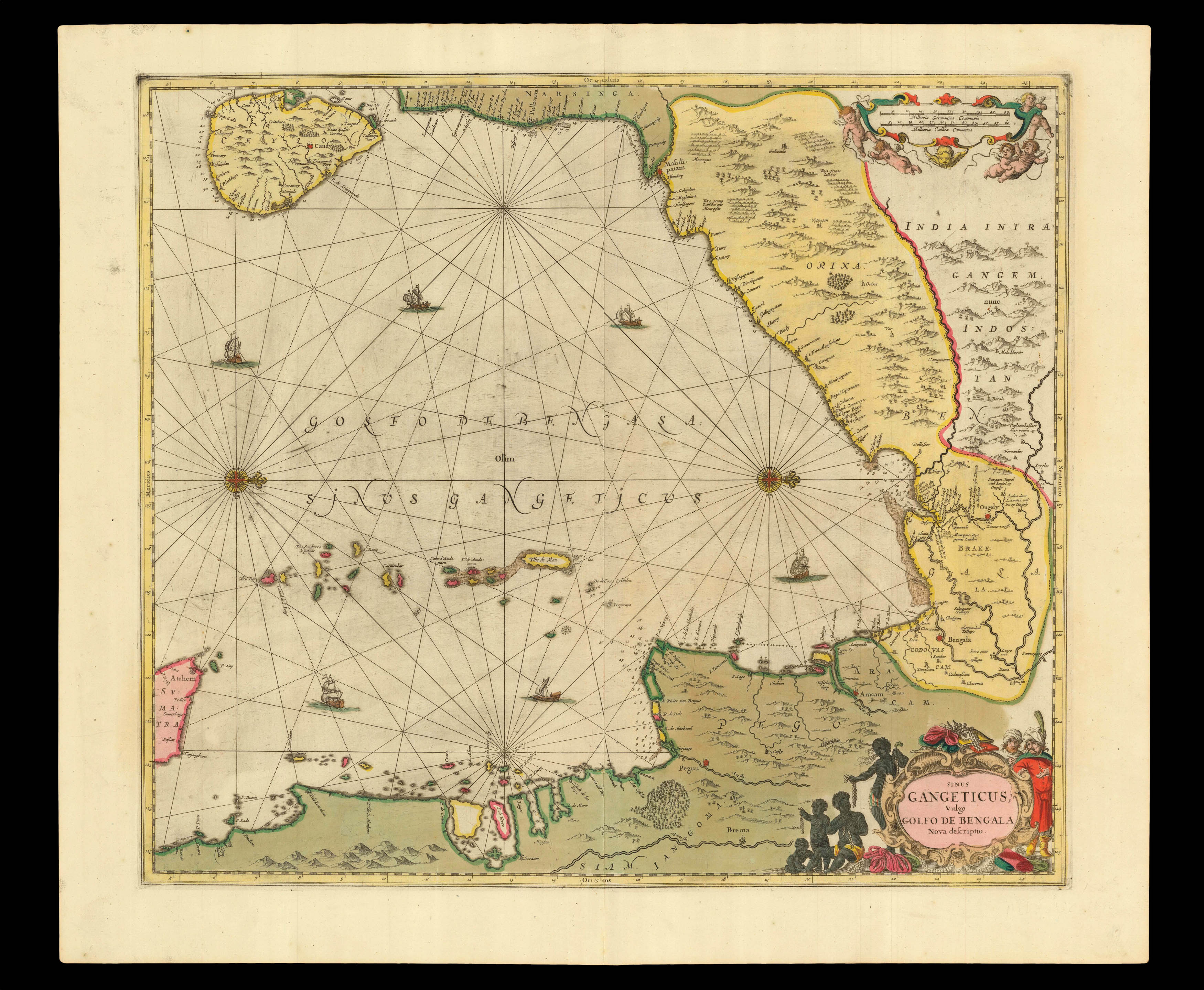
This chart of the Bay of Bengal, including the island of Ceylon, eastern India, Bangladesh, Myanmar, and a small portion of Sumatra, is one of the earliest printed seacharts of the area. Both European and oriental ships are shown crossing the waters. The land masses are dotted with tilled rice fields, rivers, mountains, forests, villages, and cities.
Although pilot guides, or rutters, supplemented by charts had been produced as early as 1584, Jansson must be cre...
This chart of the Bay of Bengal, including the island of Ceylon, eastern India, Bangladesh, Myanmar, and a small portion of Sumatra, is one of the earliest printed seacharts of the area. Both European and oriental ships are shown crossing the waters. The land masses are dotted with tilled rice fields, rivers, mountains, forests, villages, and cities.
Although pilot guides, or rutters, supplemented by charts had been produced as early as 1584, Jansson must be credited with the production of the "first real sea-atlas", which contained "a collection of charts in folio size, to serve as an atlas for general purposes" (Van der Krogt). Some Anglo-Italians might put forward for that title Robert Dudley's 'Acarno del Mare' – a work of numerable firsts, published in 1646 – but it was not until the second edition of 1661 that all the charts in it were uniformly bound.
The atlas was published in 1650, as the fifth volume to Jansson's 'Atlas Novus' – as is made explicit in the title. The volume, which was referred to as the 'Waterwereld' (Waterworld), would later be published as a stand-alone volume. Of the 23 charts in the atlas, 21 were published for the first time and, even if many have "more a characteristic of geographical maps than charts" (Koeman) and the "elaborate printed text … is not pertaining to maritime affairs" (Koeman), the work's influence was considerable, as can be seen in the output of the likes of Goos, Colom, and van Keulen.
The son of an established printer and publisher Jan Jansz., Johannes Janssonius (1588-1664), was Willem Jansz. Blaeu's main rival. In 1618, he set up his own cartographic publishing firm on the Damrak, the central canal and commercial hub of Amsterdam. In 1612, he married Elisabeth de Hondt, the daughter of Jodocus Hondius,… another of Blaeu's competitors. "Theirs was a rivalry which soon grew to include accusations of plagiarism and theft of intellectual property, a state of affairs not helped by Blaeu's use of the name "Jan Zoon" to sign his works" (Martin Woods).
These two publishing houses, and Jodocus Hondius's son, Henricus, strove constantly to outdo each other in the race to publish a multi-volume atlas, that would replace those of Abraham Ortelius and Gerard Mercator.
In 1570 Abraham Ortelius had published the first edition of his single volume atlas, 'Theatrum Orbis Terrarum', the first collection of maps with a uniform size and style. It was an immediate success. Gerard Mercator, the inventor of the projection named after him, began in 1585 to produce a series of 'Tabulae Geographicae' of differing European countries. This culminated in 1595 in the 'Atlas Sive Cosmographicae', the first use of the term "Atlas". It contained 107 maps of the world, and was completed by his son Rumold, Gerard having died the year before. There was one further edition in 1602 before the plates were acquired by Jodocus Hondius I. He published it as 'Gerardi Mercatoris Atlas Sive Cosmographicae' in 1606 with 37 newly engraved maps, taking the total to 144. Publication had moved from Duisburg to Amsterdam and the first few editions were in Latin. With this atlas Jodocus established the Hondius publishing house in Amsterdam, the center of cartographic production in the late sixteenth century, and built a successful publishing career from his Mercator-Hondius atlas.
"After his father's death in 1612, Jodocus Hondius II and his brother, Henricus, took over the family business and began to publish their own atlases, including maps that had previously belonged to their father. Unfortunately, in 1621 Jodocus Hondius II split with his brother, creating a rival publishing house. Henricus Hondius continued his father's business with his brother-in-law, Joannes Jansson" (Krogt). By 1629 the Blaeu family were becoming serious rivals to the publishing partnership of Jan Jansson and Hendricus Hondius, so they "set about revising the Mercator-Hondius atlas which (in respect of the world map) had continued unchanged for nearly thirty-five years" (Shirley 336).
Although Janssonius's first independent work was an edition of Blaeu's 'Licht der Zeervaert' in 1620, he is first associated with the Mercator-Hondius atlas in 1633, when the French edition includes his name on the title-page. The Dutch editions of 1634, 1638 and 1647 were published by Janssonius alone; but the English edition, 1636, the Latin of 1638, were issued by both Janssonius and Hondius. After 1638 the name of the atlas changed to Atlas Novus…, and from 1649 Hondius's name no longer appears on the title-page or preface. In time, Janssonius would add a fifth volume, the 'Atlas Maritimus', 1657, a significant sea-atlas; and eventually, a further five volumes including maps from every corner of the globe, by about one hundred credited authors and engravers. The final, eleventh volume, Andreas Cellarius's celestial atlas, completed the 'Atlas Major' in 1660.