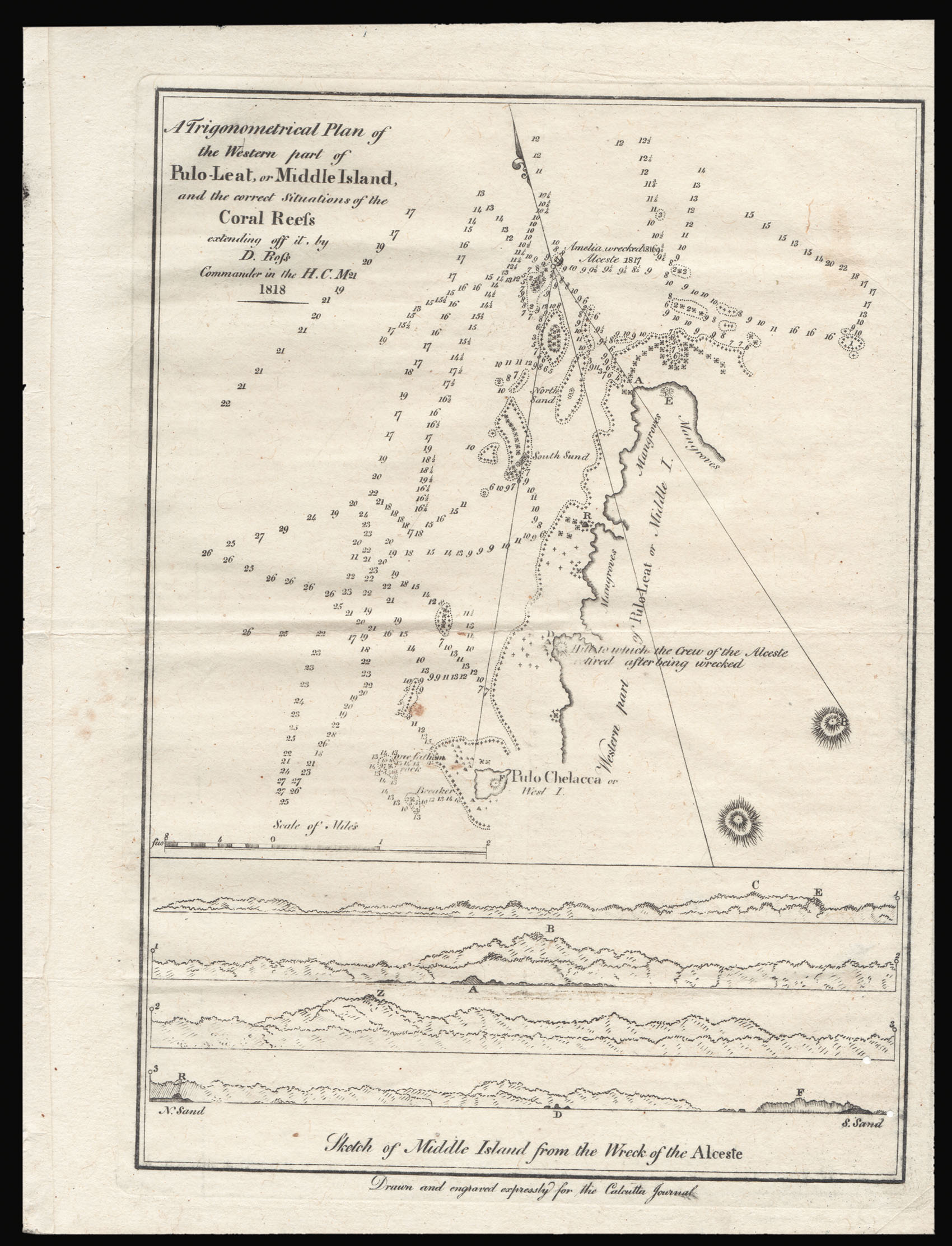
This chart of Pongok, now Pulo-Leat, shows the Western coast of the Indonesian island. It was published in the issue of the Calcutta Journal printed on 9th April 1819, and inside the newspaper there is a key corresponding to the letters shown on the map. The plan is clearly designed for sailors, with notes recording the depth of sea and sand, and the positioning of nearby rocks, trees and mangrove swamps. The wreck of H.M.S. Alceste is also shown, which grounded off the coa...
This chart of Pongok, now Pulo-Leat, shows the Western coast of the Indonesian island. It was published in the issue of the Calcutta Journal printed on 9th April 1819, and inside the newspaper there is a key corresponding to the letters shown on the map. The plan is clearly designed for sailors, with notes recording the depth of sea and sand, and the positioning of nearby rocks, trees and mangrove swamps. The wreck of H.M.S. Alceste is also shown, which grounded off the coast of the island in 1817, was evacuated by the crew and subsequently looted by Malayan pirates. The survey was undertaken and is here described by the hydrographer of the East India Company, Captain Daniel Ross, whom Clements credits as "the father of Indian Surveys". Renowned for his accurate and detailed charts of the Indian, Indonesian and Chinese coasts, Ross was elected as a Fellow of the Royal Society in 1822, and appointed Marine Surveyor General at Calcutta in 1823. In that year the Calcutta Journal was suppressed by the Governor General for its criticism of the East India Company and its editor, James Buckingham was expelled from India. Ross continued surveying throughout these controversies, and became best known for his chart of Singapore. We have been able to trace only six institutional examples of this map.
![[BRY, Theodor de] Joannes Stoflerus Mathematicus.](https://omega.crouchrarebooks.com/wp-content/uploads/2025/03/18163_1H.jpg) Johannes Stoffler
Johannes Stoffler  The Poly-olbion
 ![TAYLOR, Isaac [City of Hereford] To the right Hon[oura]ble ye Earl of Oxford High Steward of the City of Hereford...](https://omega.crouchrarebooks.com/wp-content/uploads/2025/03/21794_1H.jpg) Taylor's Plan of Hereford
Taylor's Plan of Hereford  The first atlas printed in Venice, the first wholly printed in colours, incorporating the first map to indicate Japan, the second map in a Ptolemaic atlas to show America.