Published at the Hydrographic Office of the Admiralty, Sold by Edward Stanford,
February 1865 [Corrections to 1892].
Engraved chart, dissected and mounted on linen, engraved coat of arms of the Hydrographic Office, marbled paper securing the folded map, brown slipcase with E. Stanford's label pasted on.
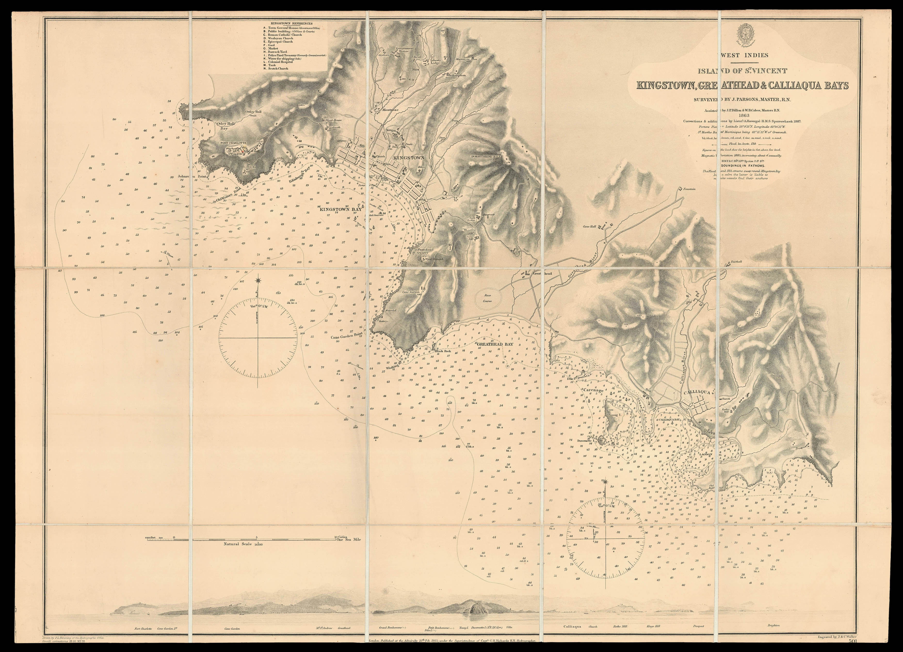
This chart shows the southern coast of the Caribbean island of St. Vincent, which was a British colony until 1979. From west to east it covers the coastline between Kingstown and Calliaqua. Fort Charlotte, a British colonial Fort built in 1763, is prominently situated on the cliffs west of Kingstown, and bears a red and yellow mark to most likely denote a light house. In Kingstown civil institutions like churches, a market and a colonial hospital are named as well as govern...
This chart shows the southern coast of the Caribbean island of St. Vincent, which was a British colony until 1979. From west to east it covers the coastline between Kingstown and Calliaqua. Fort Charlotte, a British colonial Fort built in 1763, is prominently situated on the cliffs west of Kingstown, and bears a red and yellow mark to most likely denote a light house. In Kingstown civil institutions like churches, a market and a colonial hospital are named as well as governmental and military places, the Government House and an observation point at the shore. Besides its civil aspects the map points out geographical aspects like mountains and main roads. The chart also includes soundings, anchorages, compass roses, and other signs of the sea. Below the chart is
The survey was executed in 1863 by John Parsons (Royal Navy) and the map engraved by John and Charles Walker. The two brothers, founding members of the Royal Geographic Society, were leading mapmakers and engravers working in London in the first half of the nineteenth century. They are known to have produced numerous charts for James Horsburgh and the Admiralty. Their company J & C Walker worked with the S.D.U.K. (Society for the Diffusion of Useful Knowledge) for whom they produced maps. They specialised particularly in maps of the British Empire and India. Furthermore they produced the maps for the Royal Atlas which ran to many editions.
The British Hydrographic Office was founded in 1795 by George III, who appointed Alexander Dalrymple as the first Hydrographer to the Admiralty. The first charts were produced in 1800. Unlike the U. S. Coast Survey the Hydrographic Office was given permission to sell charts to the public and they produced a great number of sea charts covering every corner of the globe. Most of the Admiralty charts produced by the Hydrographic Office delineated coastline as well as high and low water marks and record depth of water as established by soundings. In addition these charts included information on shoals, reefs, and other navigational hazards that plagued mariners across the world. Thanks to the innovations of Sir Francis Beaufort, who developed the Beaufort Scale of wind strength, the British Hydrographic Office became one of the leading producers of sea charts.