A Draft of The Great Bay, Back Bay and Harbour of Trincomalay on The Island of Zeloan,
describing all the islands, rivers, rocks and dangerous shoals, with exact marks for the shoals, & also the marks to avoid them; likewise the depths of water, and other necessary remarks, with great care and accuracy survey'd and plann'd in the year 1762
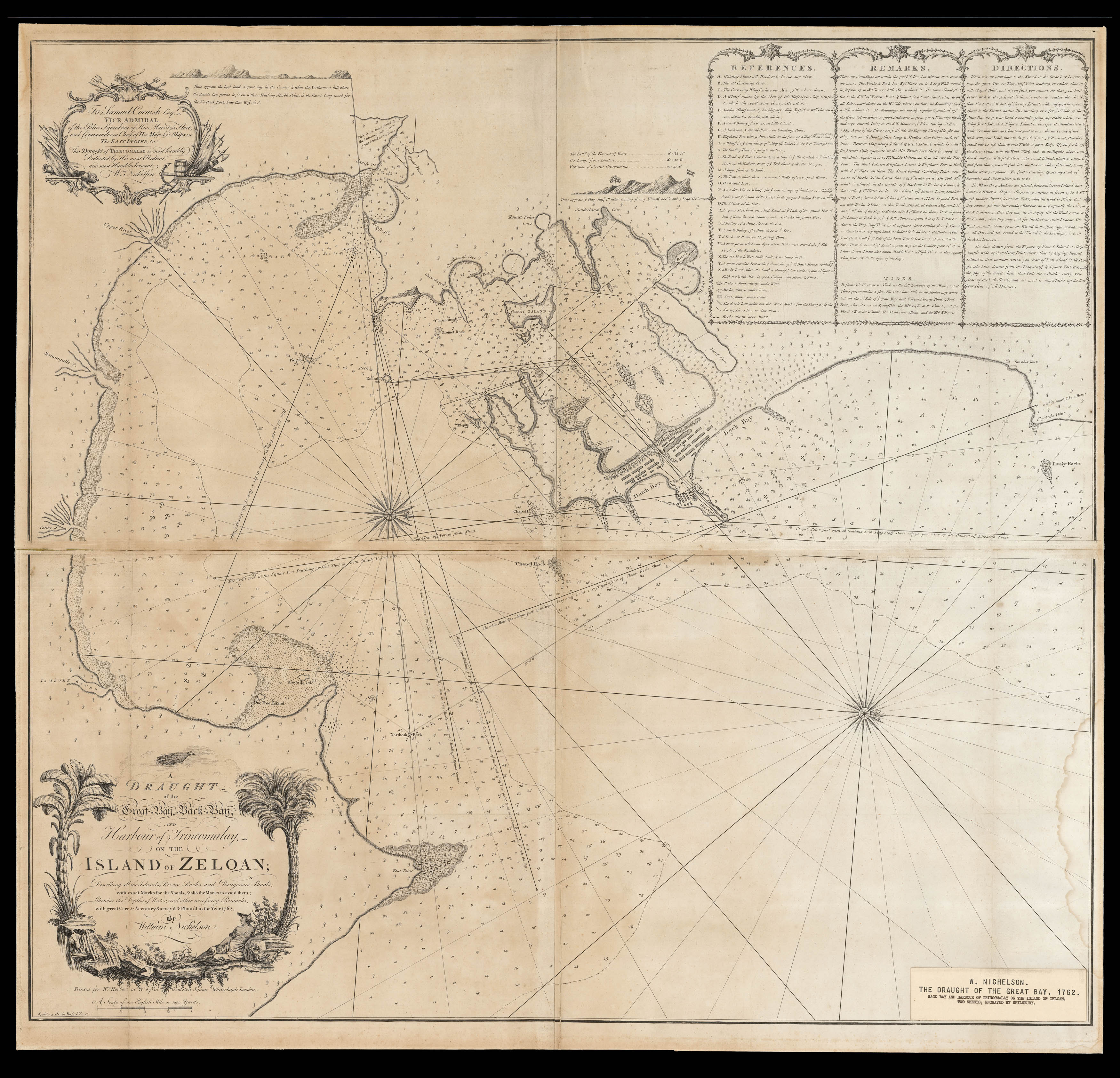
Rare chart of Trincomalee, Sri Lanka, at the dawn of British Imperial dominance over the waters of Southeast Asia.
During the mid-eighteenth century Royal Navy officer William Nichelson worked closely with publisher and mapseller William Herbert to produce numerous maps and charts of Southeast Asia. During the 1760s, Nichelson undertook expeditions around Southern Africa and India aboard the HMS Elizabeth, preparing cartographical manuscripts that were then publi...
Rare chart of Trincomalee, Sri Lanka, at the dawn of British Imperial dominance over the waters of Southeast Asia.
During the mid-eighteenth century Royal Navy officer William Nichelson worked closely with publisher and mapseller William Herbert to produce numerous maps and charts of Southeast Asia. During the 1760s, Nichelson undertook expeditions around Southern Africa and India aboard the HMS Elizabeth, preparing cartographical manuscripts that were then published by Herbert in London. Among these were some of the finest charts of the region made during the eighteenth century, many of which were compiled in A New Directory for the East Indies (1767). Nichelson also authored an account of navigational voyages to accompany the Directory.
The present chart of the northern Sri Lankan coast was included in the Directory of 1765, based on the expedition Nichelson had taken in 1762. This voyage came towards the end of the Seven Years' War, which marked the ascendency of British fortunes in Asia, supplanting France and the Netherlands as the dominant maritime power in its waters. Thus the subsequent decade saw a boom in the cartography of Southeast Asia, particularly by the Royal Navy and East India Company, which supported the publication of Herbert's Directory.
The chart focuses on Trincomalee Harbour, a seaport along the northeastern coast of Sri Lanka. At the time that this chart was produced, the majority of the island, although known to the British as Ceylon (here "Zeloan"), was ruled as the kingdom of Kandy by a native king. The coastal areas, however, invaluable as they were for trade and travel had long been held by European powers. The important Trincomalee bay, which forms the largest and most secure natural port in the Indian Ocean, had passed through French and Dutch hands throughout the previous decades, but would be formally taken by the British in 1795 and held as a Royal Navy base until Sri Lankan independence in 1948.
In addition to the forts and buildings illustrated in red along the narrow strip of land by "Back Bay" on the coast, the soundings, sandbanks and shoals in the sea are indicated. There are also rhumb lines and routes, as well as sailing directions and information about the tides given in an inset box in the upper right-hand corner. In the lower left, a cartouche formed of bending palm trees houses the title, while above the main image is the chart's dedication and two small lateral illustrations of the coastline.
Rare. We have been able to trace only two examples of this map, held at the British Library and the National Maritime Museum.