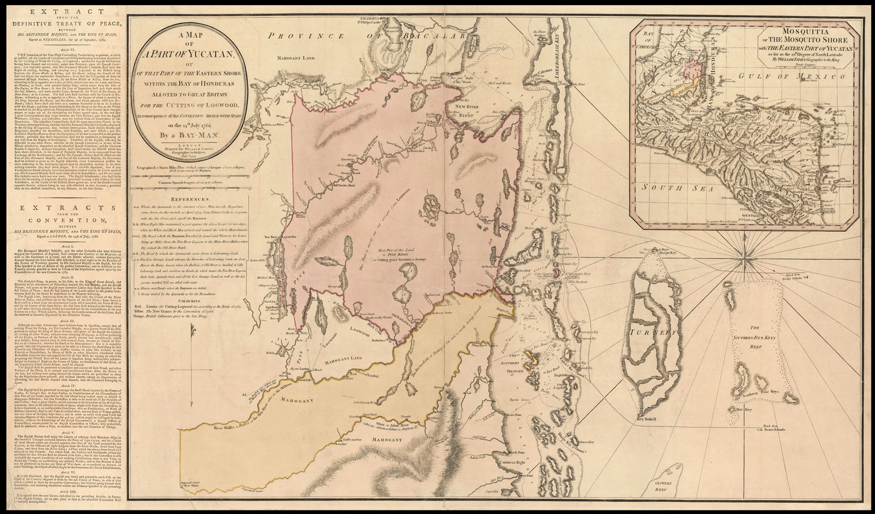
Part of the Eastern Shore within the Bay of Honduras Allotted to Gt. Britain for the Cutting of Logwood in Consequence of the Convention Signed 14 July 1786. By a Bay-Man.
Printed for William Faden, Geographer to the King,
Feb[ruar]y. 1st 1787.
Large engraved chart, with fine original hand-colour, inset map of Central America, letterpress extract from the treaty, to left of chart, minor loss to lower left corner of text, a few minor tears skilfully repaired.
A rare, large-scale British map of Belize produced after the Logwood Trade convention treaty between Spain and Great Britain.
The British have a long history in Belize. The first British settlers were a combination of pirates, buccaneers and adventurers. They lived in camps, which they used as bases to raid Spanish ships. These early settlers eventually became known as "Baymen." During the seventeenth century these settlers began to cut the logwood that was fou...
A rare, large-scale British map of Belize produced after the Logwood Trade convention treaty between Spain and Great Britain.
The British have a long history in Belize. The first British settlers were a combination of pirates, buccaneers and adventurers. They lived in camps, which they used as bases to raid Spanish ships. These early settlers eventually became known as "Baymen." During the seventeenth century these settlers began to cut the logwood that was found in abundance in the interior. Logwood is a tree from which a valuable dye used to color woollen cloth was made. Mahogany was also found in abundance and later became the main export.
There were frequent conflicts between the British and the Spanish over the right of the British to settle in Belize. In 1786 the British and Spanish governments signed a convention that permitted the Baymen to cut both logwood and mahogany as far as the Sibun River. This map is lettered and color keyed noting the limits and other information set by the treaty. On the left is an "extract" of the treaty. In the upper right is an inset map of Central America, "Mosquitia or the Mosquito Shore with the Eastern Part of the Yucatan...."
William Faden (1750-1836) began his career in cartography after taking over the business of Thomas Jefferys, a highly respected British mapmaker. Initially publishing under the name Faden and Jefferys, he followed his predecessor by specialising in maps of North America, resulting in the publication of a collection of them in the 'North American Atlas' in 1777. Twice honoured by the Royal Society for his work, he became Geographer to the King in 1783, and was chosen in 1801 to create and print the first of the Ordnance survey maps.
The map was separately published and is rarely seen in the market today.