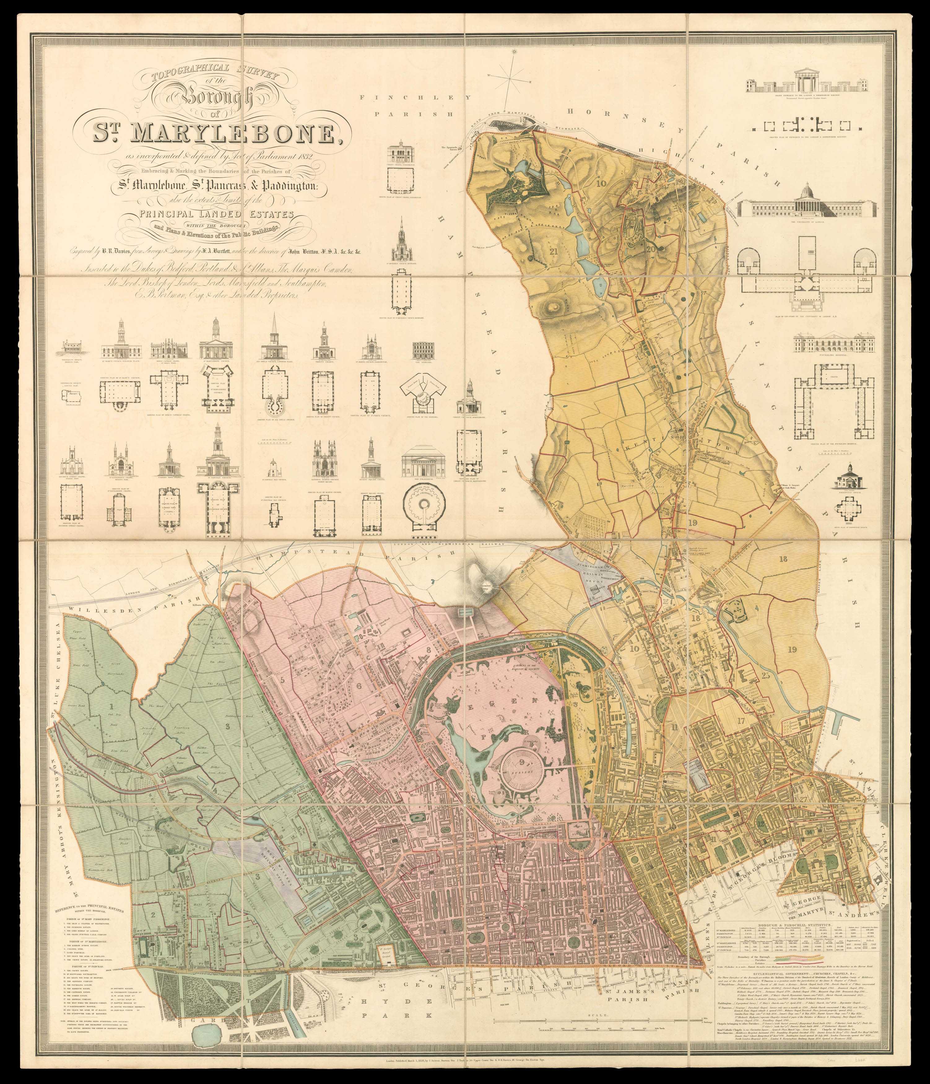
Topographical Survey of the Borough of St. Marylebone,
as incorporated & defined by Act of Parliament 1832. Embracing & Marking the Boundaries of the Parishes of St Marylebone, St Pancras, & Paddington: also the extents and limits of the Principal Landed Estates with the Borough: and Plans & Elevations of the Buildings. Engraved by B.R. Davies, from Surveys & Drawings by J.A. Bartlett under the direction of John Britton F.S.A &c. &c. &c. Inscribed to the Dukes of Bedford, Portland, & St. Ablans, The Marquis Camden, The Lord Bishop of London, Lords Mansfield and Southampton, E.B. Portman, Esq. & other Landed Proprietors.
The plan depicts the parliamentary constituency of Marylebone, which was brought into existence by the Great Reform Act of 1832; the constituency would last until 1885, when it was then split in eight new divisions.
Marylebone returned two members to Parliament in 1832: the Liberals, Viscount Portman - to whom the plan is dedicated - and Sir William Horne. The commissioners had recommended that the part of St Pancras parishes north of the Regent's Canal should n...
The plan depicts the parliamentary constituency of Marylebone, which was brought into existence by the Great Reform Act of 1832; the constituency would last until 1885, when it was then split in eight new divisions.
Marylebone returned two members to Parliament in 1832: the Liberals, Viscount Portman - to whom the plan is dedicated - and Sir William Horne. The commissioners had recommended that the part of St Pancras parishes north of the Regent's Canal should not form part of the constituency and should remain in the parliamentary county of Middlesex as this was still a largely rural area - as can be seen upon the present plan. However, the inhabitants of St. Pancras petitioned parliament for the inclusion of the entire parish, and this was accepted.
The plan is replete with information obtained by the commissioners involved in drawing up the new parliamentary constituencies. Below right is a key detailing the parishes (Paddington coloured green, Marylebone red, and St Pancras yellow), borough boundaries are marked by a yellow line, and estate boundaries with red; a table of parish statistics including number of inhabited and uninhabited houses, male and female population, age and number of male and female servants, property valuations, comparative populations from 1801 to 1831, and numbers who voted in the 1832 election. Finally, there is a table of churches, chapels, and municipal buildings, detailing their cost and dates of foundation. To the lower left is a table of principal estates with the three parishes.
Above the plan are 15 elevations and plans of churches, chapels, and municipal buildings; these include among others, Euston Station, All Souls Church Langham Place, University College London, the Foundling Hospital, the Diorama, and the Colosseum. The inclusion of these elevations and plans was the work of John Britton (1771-1857) who over saw the production of the plan, and was a leading antiquarian, and architectural historian.
Scale of 9 1/2 to 1 statute mile.
Rare: COPAC records two copies in the British Library and the Society of Antiquaries.