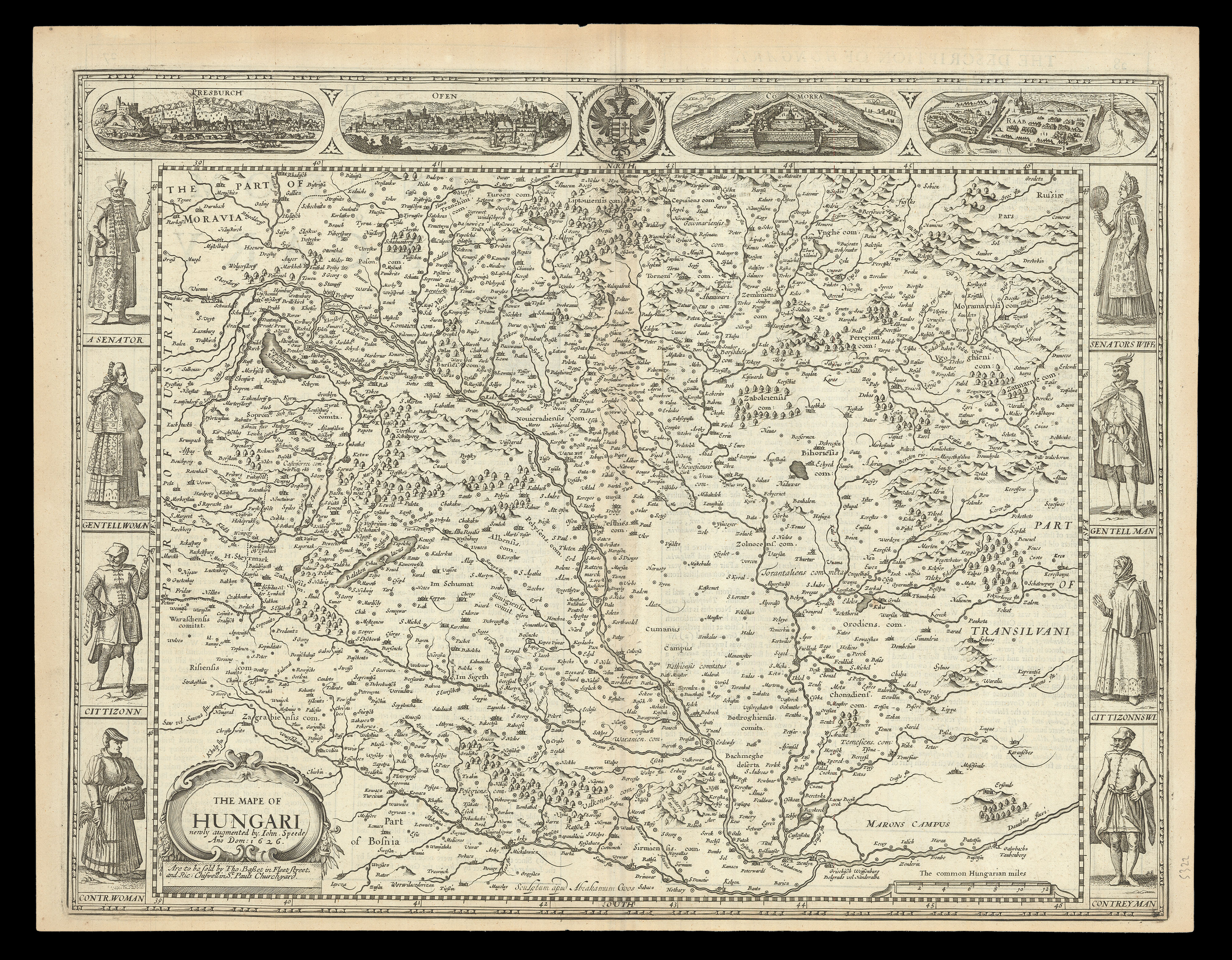
A map of 'Hungari', comprising modern-day Hungary and parts of Slovakia, from the 1676 edition of the first atlas compiled and published by an Englishman, Speed's 'Prospect'. A decorative border along the top of the map shows views of major cities, with the arms of the Holy Roman Empire at the centre. Along each side are depicted figures in regional dress of different status, from a 'Senator' and 'Senator's Wiffe', to a 'Contreyman' and 'Contr.woman'.
Accompa...
A map of 'Hungari', comprising modern-day Hungary and parts of Slovakia, from the 1676 edition of the first atlas compiled and published by an Englishman, Speed's 'Prospect'. A decorative border along the top of the map shows views of major cities, with the arms of the Holy Roman Empire at the centre. Along each side are depicted figures in regional dress of different status, from a 'Senator' and 'Senator's Wiffe', to a 'Contreyman' and 'Contr.woman'.
Accompanying text in English, 'The Description of the Kingdom of Hungary', is printed on the reverse.
John Speed (1552-1629) was the outstanding cartographer of his age. By trade a merchant tailor, but by proclivity a historian, it was the patronage of Sir Fulke Greville, poet and statesman, that allowed him to pursue this interest in earnest. His 'Theatre of Great Britain', first published in 1611 or 1612, was the first large-scale printed atlas of the British Isles. The 'Prospect of the Most Famous Parts of the World', from which the present work is drawn, appeared in 1627, bound with the 'Theatre', and is the first world atlas compiled by an Englishman to be published in England. Engraved in Amsterdam, many of the maps are anglicized versions of works by Dutch makers in distinctive carte-à-figure style, featuring borders with figures in local costume and city views.
This map is from the 1676 edition of the 'Prospect', published by Thomas Bassett and Richard Chiswell. While not as rare as the earlier publications, this edition is perhaps the most important, given that it is the first to include the nine new maps: among them, Virginia and Maryland, Barbados, and Russia. It is also the last time that the 'Prospect' was printed as an atlas.