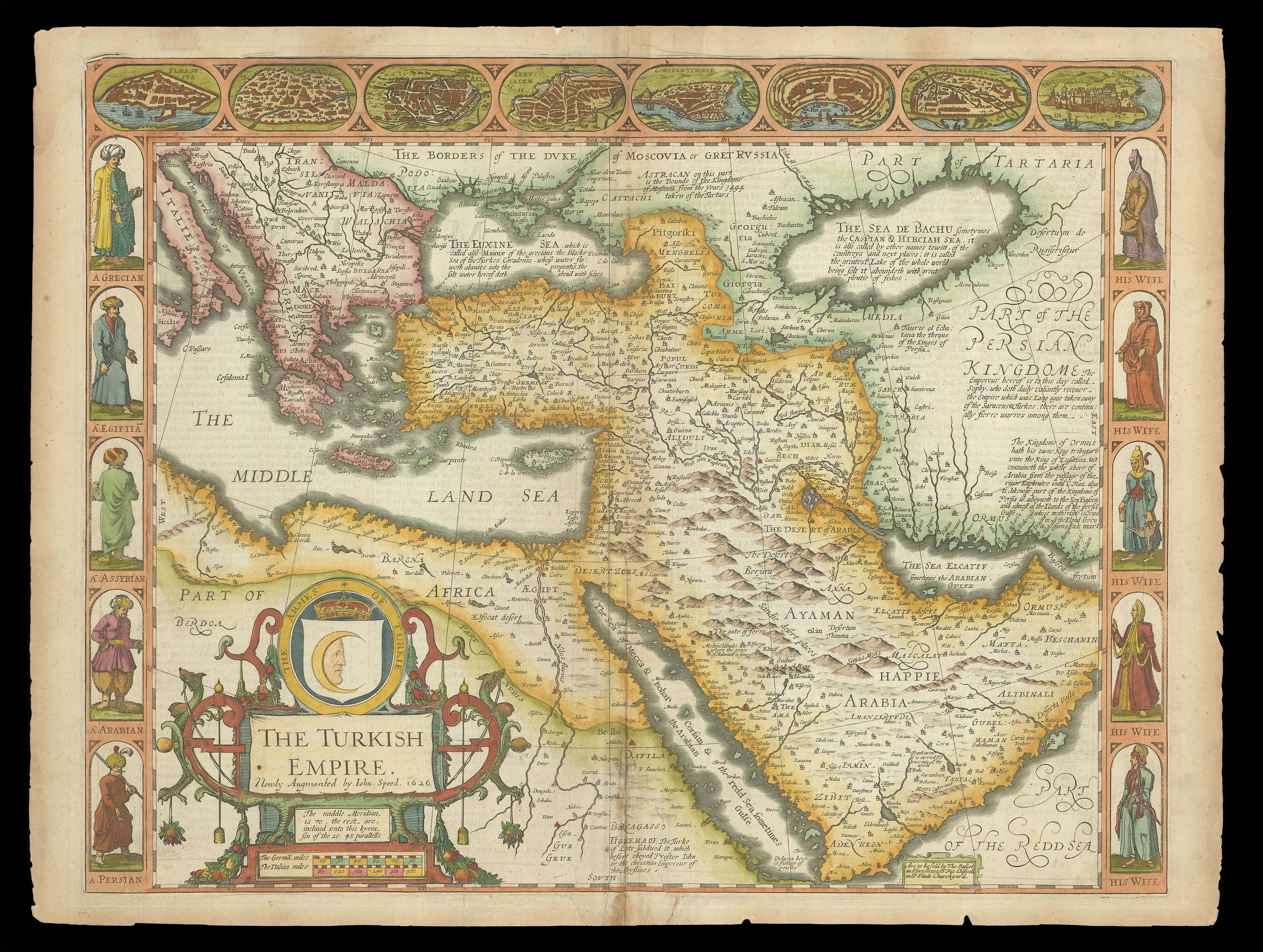
A map of the Ottoman Empire (encompassing modern-day Turkey, and parts of the Middle East and North Africa), from the first atlas compiled and published by an Englishman, Speed's 'Prospect'. Along the top of the map is a decorative border with views of major cities, including Constantinople and Alexandria. Down the left-hand side are depicted figures from different regions, among them 'A Grecian' and 'A Persian', with their wives depicted down the right-hand side. The el...
A map of the Ottoman Empire (encompassing modern-day Turkey, and parts of the Middle East and North Africa), from the first atlas compiled and published by an Englishman, Speed's 'Prospect'. Along the top of the map is a decorative border with views of major cities, including Constantinople and Alexandria. Down the left-hand side are depicted figures from different regions, among them 'A Grecian' and 'A Persian', with their wives depicted down the right-hand side. The elaborate title cartouche in the bottom left-hand corner carries a shield with fanciful Ottoman arms.
After a long period of sustained power, the supremacy of the Ottoman Empire had been dented, in 1571, by a symbolic defeat at the Battle of Lepanto. At the time this map was drawn, prolonged warfare with the Holy Roman Empire had placed further strain on the state, although it continued successfully to rule over 30 million people. European thought often dismissed the Ottoman Empire as nothing more than strength in numbers. Indeed, 'The Description of the Turkish Empire', the text printed on the reverse of the map, opens: "the Turk is admired for nothing more than his sudden advancement to so great an Empire".
John Speed (1552-1629) was the outstanding cartographer of his age. By trade a merchant tailor, but by proclivity a historian, it was the patronage of Sir Fulke Greville, poet and statesman, that allowed him to pursue this interest in earnest. His 'Theatre of Great Britain', first published in 1611 or 1612, was the first large-scale printed atlas of the British Isles. The 'Prospect of the Most Famous Parts of the World', from which the present work is drawn, appeared in 1627, bound with the 'Theatre', and is the first world atlas compiled by an Englishman to be published in England. Engraved in Amsterdam, many of the maps are anglicized versions of works by Dutch makers in distinctive carte-à-figure style, featuring borders with figures in local costume and city views.
This map is from the 1676 edition of the 'Prospect', published by Thomas Bassett and Richard Chiswell. While not as rare as the earlier publications, this edition is perhaps the most important, given that it is the first to include the nine new maps: among them, Virginia and Maryland, Barbados, and Russia. It is also the last time that the 'Prospect' was printed as an atlas.