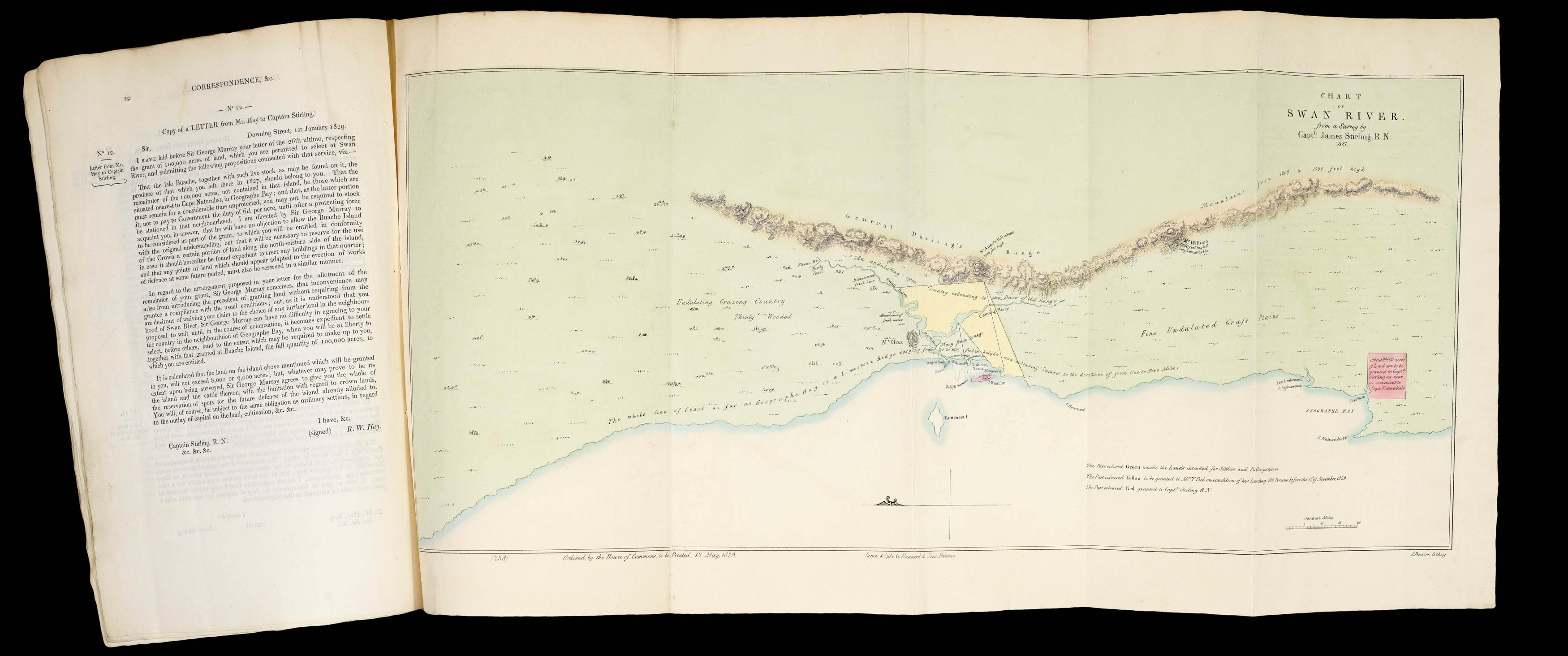
Large folding panoramic lithographed chart (280 by 630mm to the neatline) with contemporary hand-colour in full, bound into parliamentary "Hansard" paper, number 238, 'Swan River Settlement... Copies of the Correspondence of the Colonial Department with Certain Gentlemen proposing to form a Settlement in the Neighbourhood of Swan River, in Western Australia'; folio, original blue printed paper wrappers, stabbed and sewn as issued.
One of the first published charts of the first detailed survey of what would be the Swan River Colony, now Perth in Western Australia, extending as far as Cape Naturaliste in the south, and to about 200 miles north of Rottnest Island. Only preceded by the very rare chart published by Joseph Cross in January of 1829, and a 'Sketch of the New Settlement of Swan River', published in the 'Quarterly Review' of April 1829, each based on the same survey. The beautiful map is annot...
One of the first published charts of the first detailed survey of what would be the Swan River Colony, now Perth in Western Australia, extending as far as Cape Naturaliste in the south, and to about 200 miles north of Rottnest Island. Only preceded by the very rare chart published by Joseph Cross in January of 1829, and a 'Sketch of the New Settlement of Swan River', published in the 'Quarterly Review' of April 1829, each based on the same survey. The beautiful map is annotated with useful information regarding topography and vegetation, and colour-coded: green areas highlight land intended for settlers and "public purposes"; yellow areas have been granted to Peel, "on condition of his landing 400 Persons before the 1st of November, 1829"; and red, about 90,000 acres at Geographe Bay, to Stirling himself. The map extends as far inland as "General Darlings's Range". Fearful of French colonization in the Pacific, in April of 1826, James Stirling (1791-1865) was given command of the new HMS 'Success' with instructions to take a supply of currency to Sydney and then to move the misplaced and unsuccessful garrison at Melville Island. Once at Sydney, Stirling was soon persuaded by Governor, Sir Ralph Darling, to sail west instead and examine the coast with the idea in mind of establishing a defensive garrison or other settlement that might open trade with the East Indies. Stirling "sailed in 1827 and during a fortnight's visit was much impressed with the land in the vicinity of the Swan River. So also, was the New South Wales government botanist, Charles Frazer, whose report added weight to Stirling's political and commercial arguments in favour of its immediate acquisition and Stirling's appointment to establish a new colony there… under the direct control of the British government, and superintended initially by Stirling: a bill would soon be brought before parliament to provide for its government; private capitalists and syndicates would be allotted land in the proposed settlement according to the amount of capital and the money they spent on fares and equipment; priority of choice would be given only to those who arrived before the end of 1830, and no syndicate or company would be the exclusive patron and proprietor of the settlement. On 2 May 1829 Captain C. H. Fremantle of the 'Challenger' took possession, at the mouth of the Swan River, of the whole of Australia which was not then included within the boundaries of New South Wales. Stirling, who arrived later with his family and civil officials in the store-ship Parmelia, proclaimed the foundation of the colony on 18 June" (Crowley). The accompanying report consists of twelve articles of correspondence, mostly to and from Thomas Peel (1793-1865), concerning his proposals to help settle the new colony: "In 1828 Peel went to London and was planning to emigrate to New South Wales, when reports of the new free colony to be founded at Swan River changed his mind. He joined a syndicate of financiers in proposing to the government a plan whereby they would transfer ten thousand settlers with requisite stock and stores to the new colony within four years, and place them each on 200 acres of land, in return for which the syndicate wished to receive four million acres of land. The Colonial Office, however, was under pressure from Captain (Sir) James Stirling, who had explored the Swan River in 1827, either to grant him the right to develop the place under a proprietary charter, or to proclaim it a new crown colony of which he would be the governor. When Sir George Murray took charge at the Colonial Office in May 1828 he did not wish to grant a charter, or to incur the expense of forming a colony. The interest of Thomas Peel's association of investors seems to have been a deciding factor in persuading the government that the place could be a crown colony and at the same time be largely developed by outside capital. The government, however, felt it could not agree to the amount of territory the investors wished to receive, and could sanction only a grant of one million acres. At this, all the financiers interested withdrew, except Thomas Peel. While he hesitated, Solomon Levey proposed a ten-year partnership with him in the venture, to which he agreed. A deed of co-partnership was drawn up between them, a long and complicated document by which Levey was to finance the scheme and Peel, not being as wealthy as was thought, was to be the salaried manager of it in the colony, although he was to apply for the title deeds to the land in his own name, it being understood that these lands, with the exception of 25,000 acres, were in joint ownership" (Hasluck).
bibliography:
bibliography:
Crowley, and Hasluck 'Australian Dictionary of Biography', online; Ferguson 1265