Double-page engraved map, fine original hand-colour in outline, some slight offsetting, contemporary annotation on verso in brown ink, some nicks and light soiling to margins.
In the mid 1570s, Christopher Saxton was authorised by the Queen's Privy Council to survey and map the counties of England and Wales, a task which he had completed by 1579, when the resulting maps were collected and published in his 'Altas of England and Wales', the first national atlas ever produced. This map of Herefordshire is found first of 34 county maps collected in the seminal work. Fittingly, it is also the first map of the county itself ever to have been produced. ...
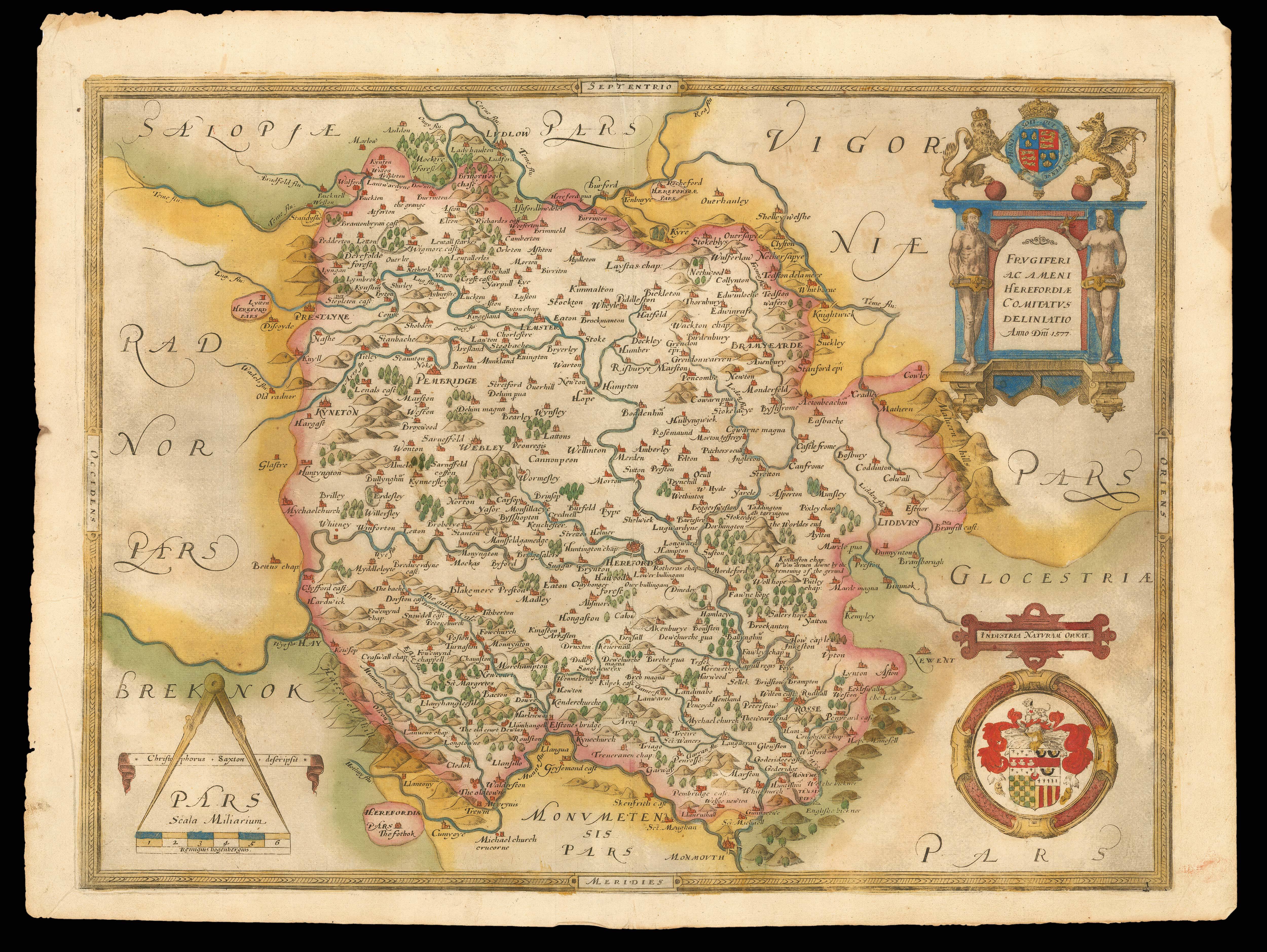
In the mid 1570s, Christopher Saxton was authorised by the Queen's Privy Council to survey and map the counties of England and Wales, a task which he had completed by 1579, when the resulting maps were collected and published in his 'Altas of England and Wales', the first national atlas ever produced. This map of Herefordshire is found first of 34 county maps collected in the seminal work. Fittingly, it is also the first map of the county itself ever to have been produced. Saxton has expressed the landscape, towns and estates within each county, represented on this map by the illustrated hills, rivers, bridges, Churches and deer parks. The latter are used to symbolise the land owned by gentry, and on receiving his personal proof copy, the Secretary of State, Lord Burghley, noted down the names of the most influential families to the side of their estates, such as Parry of Newcourt and Baskerville of Eardisley. Each town is labelled with its name, the spelling attesting to the sixteenth century pronunciation, from example, 'Lemster' for modern Leominster, and 'Snowdell' for Snodhill. While these town names are written in Latin, the names of the surrounding counties are in Latin. The Golden Valley in West Herefordshire is here labelled 'The Gilden Vale', the first published use of this name. The map also records the 1575 landslide on Marcle Hill with the annotation that Kinnaston Chapel was 'dreun downe by the removing of the ground'.
An elaborate cartouche in the top right corner of the map contains the county title in Latin, flanked by Adam and Eve, and surmounted by the royal coat-of-arms. Below this, the Seckford coat-of-arms is shown, along with its later Latin motto 'industria naturam ornat', in honour of Saxton's patron, Thomas Seckford. The scale is found in the bottom left corner of the map. Despite one account claiming that the copper plate of Herefordshire was one of the only ones engraved by Saxton himself, the name of the Flemish engraver, Remigius Hogenberg, is found below the scale bar, as it is on many other of Saxton's maps. In fact, there is no evidence that Saxton engraved any of the maps produced under his name, which are instead testament to the combined skills of cartographer, engraver and painter. Additionally, like all the maps in Saxton's 'Atlas of England and Wales', this map bears his watermark, a bunch of grapes, to identify the work as original.
bibliography:
bibliography:
Herefordiae Comitatus f.95' (The British Library Online Gallery, 2009); Smith, 'Saxton, Speed and Early Mapmakers' (The History of Ewyas Lacy, 2010); White, 'The natural history of Selborne' (Whittaker and Company, 1836).