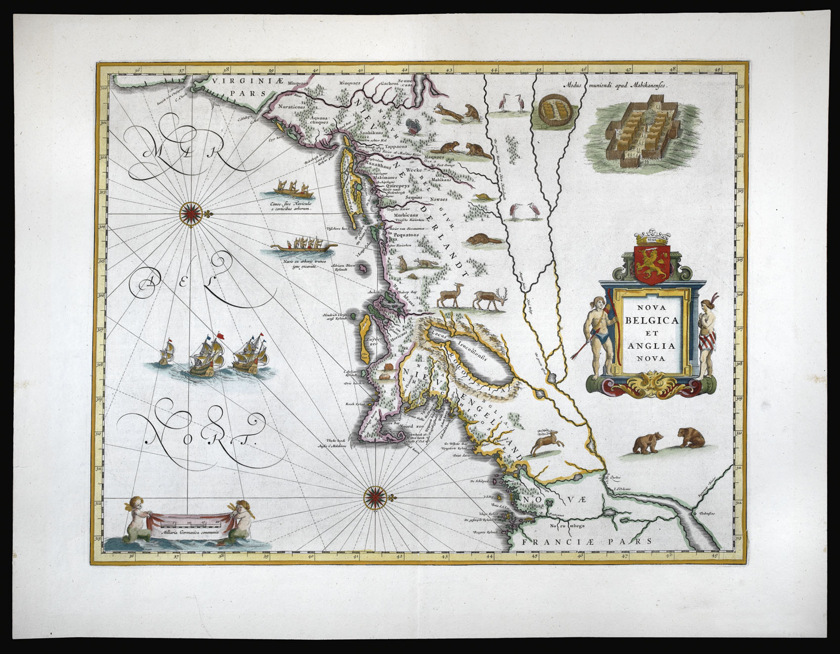
Blaeu's important map of New England, based on Adriean Block's manuscript map of 1614, first published in 1635 in Blaeu's 'Theatrum Orbis Terrarum', 1635. This example was issued in the first edition of the 'Atlas Maior' of 1662. The map covers the east coast of North America from Virginia to Quebec, showing New York and Long Island down past Cape Cod.
Block (1567 – 1627), a fur trader and navigator, explored the coastal area and river valleys between Cape Cod a...
Blaeu's important map of New England, based on Adriean Block's manuscript map of 1614, first published in 1635 in Blaeu's 'Theatrum Orbis Terrarum', 1635. This example was issued in the first edition of the 'Atlas Maior' of 1662. The map covers the east coast of North America from Virginia to Quebec, showing New York and Long Island down past Cape Cod.
Block (1567 – 1627), a fur trader and navigator, explored the coastal area and river valleys between Cape Cod and Manhattan, resulting in some of the most important advancements in the mapping of the east coast at the time. Block's map was the first to delineate Manhattan as an island, and also the first to name "Manhates" and "Niev Nederlandt". Blaeu's map is significant as the first printed map to show these discoveries, and also as the first to be embellished with depictions of otters, beavers and polecats. The map also includes scenes of Indian natives paddling their canoes to the shore.
Burden discusses the map in depth in his 'The Mapping of North America':
"It has been noted that the time difference between 1614, the date of the manuscript, and Blaeu's map whose first appearance is in 1635, appears long for such an important advance. It would seem highly feasible that Blaeu, who published many separately issued maps, would have wanted to produce one like this sooner. However, evidence points to the fact that it could not have been made before 1630. The Stokes Collection in New York possesses an example of the map on thicker paper without text on the reverse which could well be a proof issue of some kind.
There are features on Blaeu's map that differ from the Block chart. Some of these could be accounted for by the fact that the surviving figurative map is not the original, and that the copyist omitted some place names that are referred to in the text of de Laet's work. Block drew on Champlain's map of 1612 for the depiction of the lake named after him, but it is here called 'Lacus Irocoisiensis'. Blaeu does not appear to have updated this part of his map. The lack of interrelation between the Dutch or English colonies and the French, led for some time to the eastward displacement of this lake when its true position would be north of the Hudson River. Some nomenclature has its origins in Blaeu's second 'Paskaert' of c.1630, and others, such as 'Manatthans', in de Laet. The colony of 'Nieu Pleimonth' is identified. This and other English names along that part of the coast are largely derived from Smith's 'New England', 1616.
Cape Cod is here improved over the Block manuscript by being reconnected to the mainland, the narrow strait having been removed. The coastline between here and Narragansett Bay, which can be clearly recognised, is not so accurate. 'Adriaen Blocx Eylandt' leads us to the 'Versche Rivier', or Connecticut River, which Block ascended as far as was possible. 't Lange Eyland is named; however, it is incorrectly too far east, being applied to what is possibly Fishers Island. 'De Groote bay' marks Long Island Sound. The Hudson River is still not named as such, but is littered with Dutch settlements, and the failed Fort Nassau is here depicted renamed as 'Fort Orange'. He does, however, improve on the direction of its flow. Blaeu separates the sources of the Hudson and Delaware Rivers which had been causing some confusion. 'Nieu Amsterdam' is correctly marked as a fort at the tip of an island separated on the east side by 'Hellegat', or the East River. The coastline south of Sandy Hook also shows signs of improvement."