Chart of the island of Java with parts of Sumatra, Borneo and Bali. The chart highlights coastal details and shows the Dutch capital in the East Indies at Batavia (Jakarta).
First published in the 1657 edition of Janssonius's sea-atlas of the world, 'Waterwereld', volume five of his 'Novus Atlas'. The first, 1650 issue, includes a chart of the Indian Ocean, the Gulf of the Ganges, and the Pacific Ocean. An expanded edition, seven years later, included charts of ...
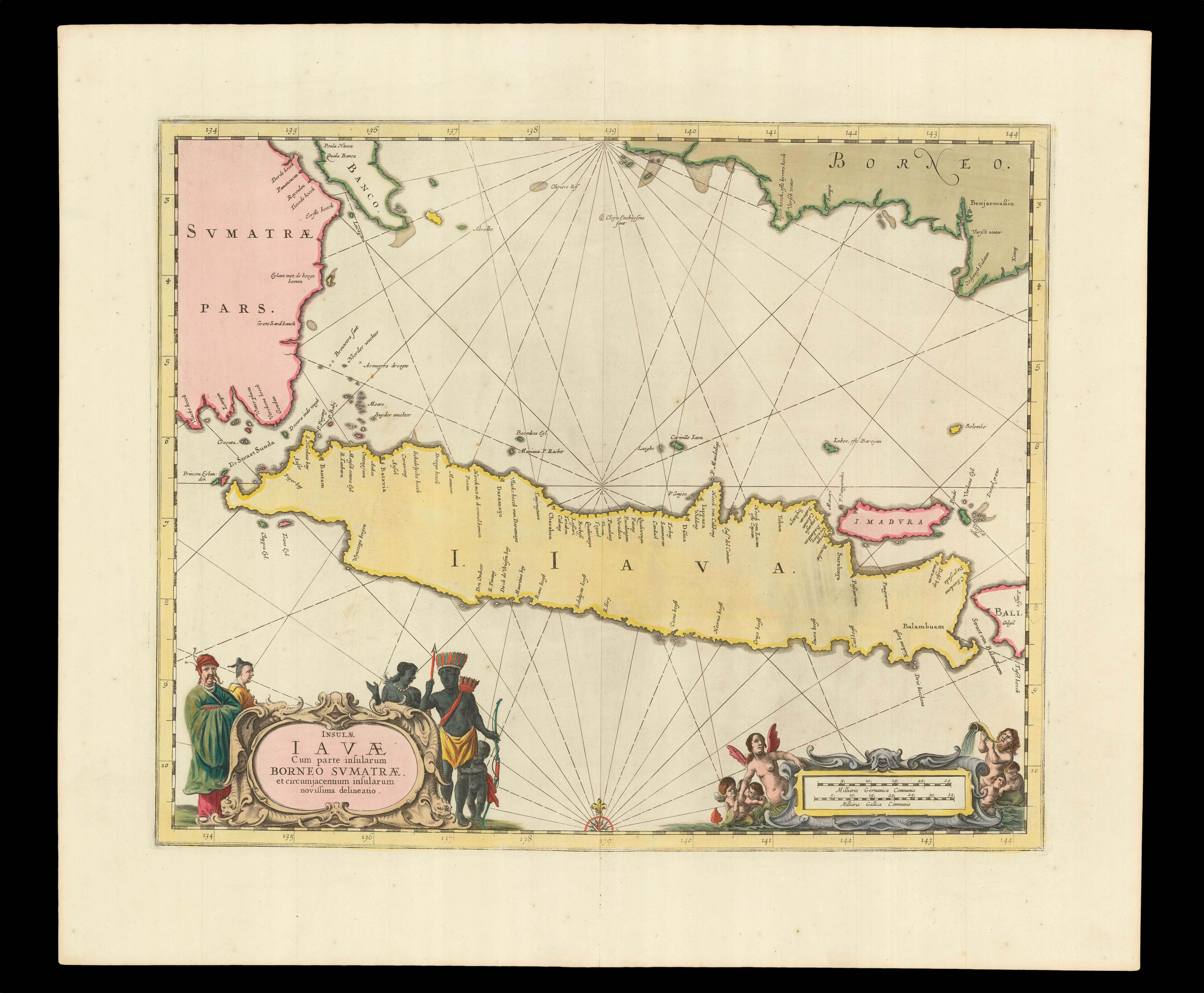
Chart of the island of Java with parts of Sumatra, Borneo and Bali. The chart highlights coastal details and shows the Dutch capital in the East Indies at Batavia (Jakarta).
First published in the 1657 edition of Janssonius's sea-atlas of the world, 'Waterwereld', volume five of his 'Novus Atlas'. The first, 1650 issue, includes a chart of the Indian Ocean, the Gulf of the Ganges, and the Pacific Ocean. An expanded edition, seven years later, included charts of Java, as here, Sumatra, and Borneo. The chart shows "improvement in detail, but not in the island's location, which is representative of the disparity between published Dutch charts and the knowledge of Dutch pilots... Jansson placed the westernmost tip of Java at 134 degrees east of the Cape Verde Islands, which is about 5 degrees further east than its true position, depending on precisely what point in the Cape Verdes was imagined as prime" (Suarez).
Although pilot guides, or rutters, supplemented by charts had been produced as early as 1584, Jansson must be credited with the production of the "first real sea-atlas", which contained "a collection of charts in folio size, to serve as an atlas for general purposes" (Van der Krogt). Some Anglo-Italians might put forward for that title Robert Dudley's 'Acarno del Mare' – a work of numerable firsts, published in 1646 – but it was not until the second edition of 1661 that all the charts in it were uniformly bound.
The atlas was published in 1650, as the fifth volume to Jansson's 'Atlas Novus' – as is made explicit in the title. The volume, which was referred to as the 'Waterwereld' (Waterworld), would later be published as a stand-alone volume. Of the 23 charts in the atlas, 21 were published for the first time and, even if many have "more a characteristic of geographical maps than charts" (Koeman) and the "elaborate printed text … is not pertaining to maritime affairs" (Koeman), the work's influence was considerable, as can be seen in the output of the likes of Goos, Colom, and van Keulen.
The son of an established printer and publisher Jan Jansz., Johannes Janssonius (1588-1664), was Willem Jansz. Blaeu's main rival. In 1618, he set up his own cartographic publishing firm on the Damrak, the central canal and commercial hub of Amsterdam. In 1612, he married Elisabeth de Hondt, the daughter of Jodocus Hondius,… another of Blaeu's competitors. "Theirs was a rivalry which soon grew to include accusations of plagiarism and theft of intellectual property, a state of affairs not helped by Blaeu's use of the name "Jan Zoon" to sign his works" (Martin Woods).
These two publishing houses, and Jodocus Hondius's son, Henricus, strove constantly to outdo each other in the race to publish a multi-volume atlas, that would replace those of Abraham Ortelius and Gerard Mercator.
In 1570 Abraham Ortelius had published the first edition of his single volume atlas, 'Theatrum Orbis Terrarum', the first collection of maps with a uniform size and style. It was an immediate success. Gerard Mercator, the inventor of the projection named after him, began in 1585 to produce a series of 'Tabulae Geographicae' of differing European countries. This culminated in 1595 in the 'Atlas Sive Cosmographicae', the first use of the term "Atlas". It contained 107 maps of the world, and was completed by his son Rumold, Gerard having died the year before. There was one further edition in 1602 before the plates were acquired by Jodocus Hondius I. He published it as 'Gerardi Mercatoris Atlas Sive Cosmographicae' in 1606 with 37 newly engraved maps, taking the total to 144. Publication had moved from Duisburg to Amsterdam and the first few editions were in Latin. With this atlas Jodocus established the Hondius publishing house in Amsterdam, the center of cartographic production in the late sixteenth century, and built a successful publishing career from his Mercator-Hondius atlas.
"After his father's death in 1612, Jodocus Hondius II and his brother, Henricus, took over the family business and began to publish their own atlases, including maps that had previously belonged to their father. Unfortunately, in 1621 Jodocus Hondius II split with his brother, creating a rival publishing house. Henricus Hondius continued his father's business with his brother-in-law, Joannes Jansson" (Krogt). By 1629 the Blaeu family were becoming serious rivals to the publishing partnership of Jan Jansson and Hendricus Hondius, so they "set about revising the Mercator-Hondius atlas which (in respect of the world map) had continued unchanged for nearly thirty-five years" (Shirley 336).
Although Janssonius's first independent work was an edition of Blaeu's 'Licht der Zeervaert' in 1620, he is first associated with the Mercator-Hondius atlas in 1633, when the French edition includes his name on the title-page. The Dutch editions of 1634, 1638 and 1647 were published by Janssonius alone; but the English edition, 1636, the Latin of 1638, were issued by both Janssonius and Hondius. After 1638 the name of the atlas changed to Atlas Novus…, and from 1649 Hondius's name no longer appears on the title-page or preface. In time, Janssonius would add a fifth volume, the 'Atlas Maritimus', 1657, a significant sea-atlas; and eventually, a further five volumes including maps from every corner of the globe, by about one hundred credited authors and engravers. The final, eleventh volume, Andreas Cellarius's celestial atlas, completed the 'Atlas Major' in 1660.
VOC — Vereenigde Oostindische Compagnie — Dutch East India Company
The VOC and its subsidiaries were the first joint stock companies in history, and the forerunners of modern corporations; eventually giving rise to a multi-national global empire, where money, and the ability to manipulate and move it, becomes the principal resource and driving force.
For nearly one hundred years, after Vasco da Gama discovered a sea route to India in 1499, the Portuguese and the Spanish were dominant in the eastern and western hemispheres respectively. This dominance was aided by a policy of extreme cartographic secrecy by both crowns, and returning ships were required to surrender both their charts and information on any discoveries made. All charts were state property, and illegal use or copying was punishable by death. However, smuggling often took place, and piracy by both English and Dutch vessels meant that, eventually, the routes to both the "Old", or East, and "New", or West, Indies became available to northern Europe. Using this purloined information, the British East India Company – EIC- and Dutch Vereenigde Oostindische Compagnie –VOC — were established — in 1600 and 1602 respectively — to cash in on the lucrative trade in nutmeg, pepper, cinnamon, cloves, and other spices.
These monopolistic giants continued the tradition of jealously guarding the secret charts that laid the path to the source of their immense wealth and power. Both organisations employed teams of chartmakers or hydrographers to record the most up-to-date navigational information for speedy distribution in order to obtain commercial advantage with the quickest routes to the most profitable markets. The principal vector for this information was the "pascaert".
The publication of these pascaerts proudly makes proprietary information inviting and accessible to a new investor class. In joining the chase around the globe for a nutmeg, one of the smallest countries in the world created a vast empire by applying the principle of capital investment to their ventures, eventually driving the Spanish, the Portuguese, and even the English from the East Indies.
bibliography:
bibliography:
Suarez 'Early Mapping of Southeast Asia', page 207