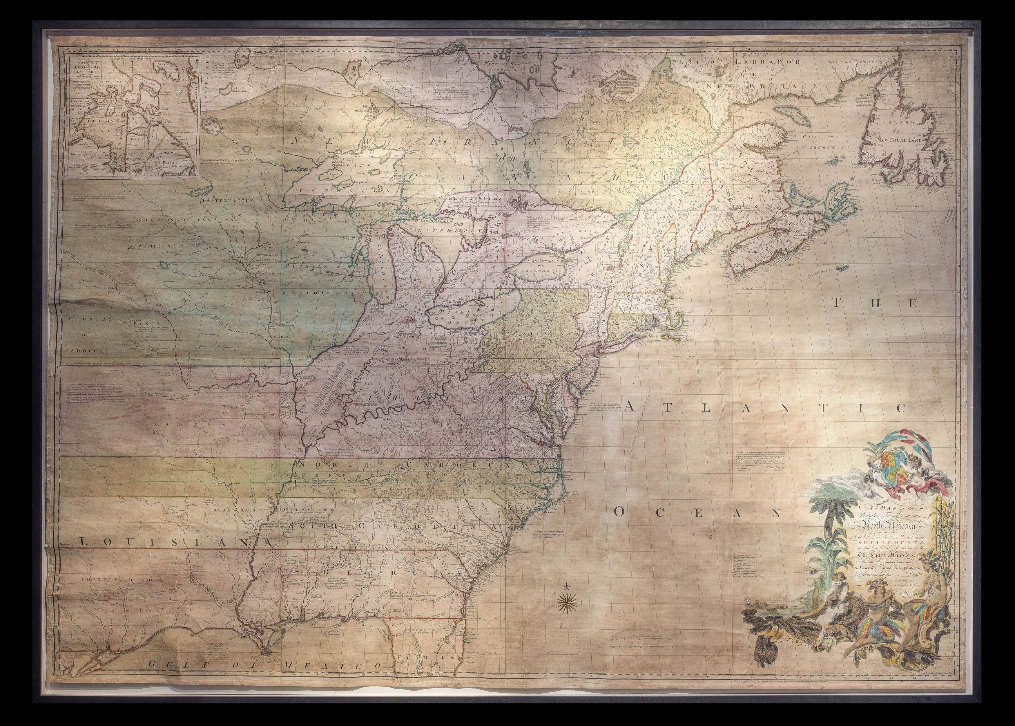
A Map of the British and French Dominions in North America.
With the Roads, Distances, Limits, and Extent of the Settlements, Humbly Inscribed to the Right Honourable the Earl of Halifax, And the other Right Honourable The Lords Commissioners for Trade & Plantations, by their Lordships. Most Obliged and very humble Servant Jno, Mitchell.
Publish'd by the Author Feb 13th 1755 according to the Act of Parliament, and Sold by And. Millar opposite Katharine Street in the Strand,
1755
Large engraved wall map on eight sheets joined and mounted on linen, with superb contemporary hand-colour in full, the boundaries extending across the map to the west, indicating manifest destiny.
Mitchell's map is widely regarded as the most important map in American history. Prepared on the eve of the Seven Years' War (or French and Indian War), it was the second large format map of North America printed by the British (the first being Henry Popple's map of 1733), and included the most up to date information of the region: "the result of a uniquely successful solicitation of information from the colonies" (Edney). Over the following two hundred years, it would play...
Mitchell's map is widely regarded as the most important map in American history. Prepared on the eve of the Seven Years' War (or French and Indian War), it was the second large format map of North America printed by the British (the first being Henry Popple's map of 1733), and included the most up to date information of the region: "the result of a uniquely successful solicitation of information from the colonies" (Edney). Over the following two hundred years, it would play a significant role in the resolution of every significant dispute involving the northern border of the then British Colonies and in the definition of the borders of the new United States of America.
John Mitchell (1711-1768) was born in Virginia and educated in medicine in Edinburgh, Scotland. He returned to Virginia and practised as a physician, before emigrating back to England in 1746, where he was introduced to the president of the Board of Trade and Plantations, the Earl of Halifax. Matthew Edney suggests that it was most likely Halifax who approached Mitchell to serve as an expert on colonial affairs, and later commissioned him to draw a map of America to define English territorial rights. Mitchell's first attempt resulted in a manuscript map finished in 1750. This prototype proved insufficient, and Halifax issued a special directive ordering every colonial governor on the North American mainland to send detailed accounts and maps of their colonies and boundaries. He also gave Mitchell access to the Board's archives, including maps by Joshua Fry and Peter Jefferson, Christopher Gist, George Washington, and John Barnwell.
The map was engraved by Thomas Kitchin and published by Andrew Millar. The colouring outlines British colonial claims. There is extensive text throughout describing and explaining various features including natural resources and potential for settlement of frontier regions, as well as notes claiming British boundaries over French ones. The text outlines different legal justifications for British settlements: some areas are declared de facto British because of existing British settlements; others are taken as included in royal charters issued to settlers by British monarchs; and some are marked as acquired from Native Americans. The title cartouche has been carefully designed to suggest the fertile potential of the American colonies, decorated with wheat, a beaver and barrels of molasses. The two Native American figures are shown looking up towards the crest of the royal family and the union flag, indicating the dependence of the colonies upon Britain.
The map was used by Halifax to push his aggressive colonial policies in North America. He was reluctant to concede any territory to the French, and used Mitchell's work to stymie a neutral zone in Ohio proposed by the diplomat Sir Thomas Robinson. Mitchell's work, although impeccably sourced, was an unapologetic statement of British claims in the continent, to the extent that the chancellor, the Earl of Hardwicke, was worried that its publication would lead to public outcry if the government compromised with the French.
Mitchell's work was immediately popular, and spawned a host of imitations. The map's credentials, linked to both Halifax and the Board of Trade, gave it an authority beyond contemporary productions: even Henry Popple's landmark map of America was only produced by the permission of the Board of Trade, rather than with its co-operation. It represented both a landmark in the history of the cartography of America - as the most efficiently sourced and drawn map of the period - but also in the use of cartography in government policy.
This is an example of Tooley's first edition, second issue (54b), of five; and Pritchard & Taliaferro's 4th state, of seven, with the towns of Leicester and Worcester appearing in Massachusetts.
bibliography:
bibliography:
Matthew H. Edney, 'John Mitchell's Map of North America (1755): A Study of the Use and Publication of Official Maps in Eighteenth-Century Britain', Imago Mundi 60 (2008), pp.63-85; Lawrence Martin, 'John Mitchell', in Dictionary of American Biography, 1934, 13:50; Pritchard & Taliaferro, 4; Seymour Schwarz and Ralph E. Ehrenberg, The Mapping of America (London: Wellfleet Press, 1980), pp.159-160; Stevens & Tree 54b.