BRY, Theodor de; Thomas HARIOT; John WHITE; Jacques LE MOYNE DE MORGUES; Hans STADIUS; and Girolamo BENZONI
Frankfurt,
Johan Wechel,
1590 - 1594 [1597]
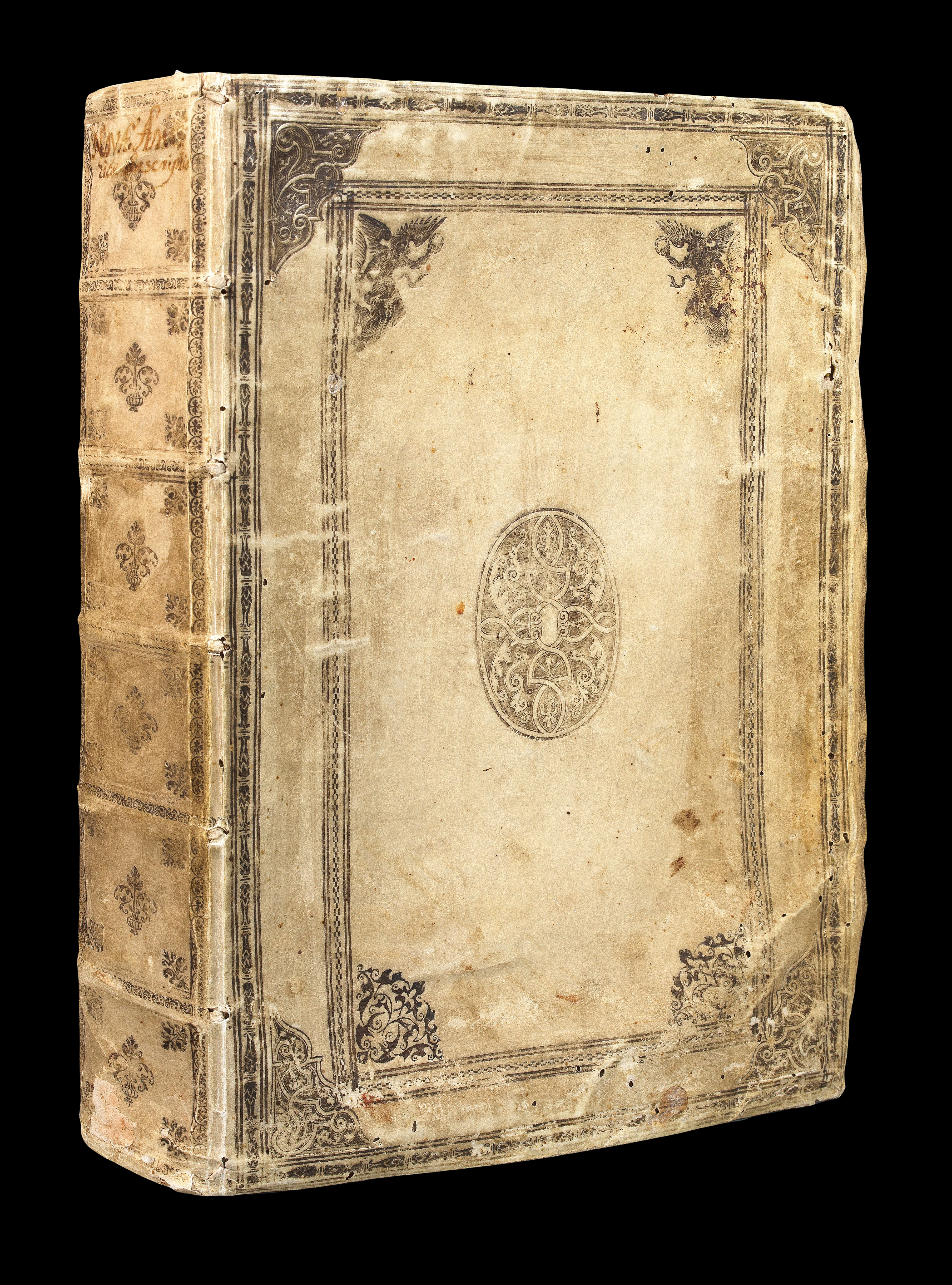
First editions. Folio (340 by 250mm). Four parts in one volume: I 'Virginiae': double-page engraved map, 28 half- or full-page plates; II 'Florida': double-page engraved map, 42 half-page plates; 'Brasiliae': double-page engraved map, 46 half-page plates; 'Americae': double-page engraved map, 24 half-page plates; contemporary limp vellum, elaborately decorated in silver with fillets, roll-tools, corner-pieces and arabesques, all edges gilt and gauffered, remains of 4 silk finger tabs, and 2 pairs of ties.
An exceptionally fine collection of the first four parts of De Bry's famous and influential collection of "Grand Voyages" to the New World, in a magnificent contemporary binding, decorated in silver and gold.
De Bry's "Grand Voyages" is one of the finest collections of voyages published during the early golden age of European exploration, and presents more than a century of European effort to take possession of the New World, materially and intellectually. The co...
An exceptionally fine collection of the first four parts of De Bry's famous and influential collection of "Grand Voyages" to the New World, in a magnificent contemporary binding, decorated in silver and gold.
De Bry's "Grand Voyages" is one of the finest collections of voyages published during the early golden age of European exploration, and presents more than a century of European effort to take possession of the New World, materially and intellectually. The collection is famed for the quality of its ethnographic and biological illustrations, produced, for the most, part using authentic models and the iconography disseminated via this popular work dominated the European view of the new world for more than a century after its publication.
The history of the publication of the "Grand Voyages" is neatly summarized in the Church catalogue as follows: "Theodor De Bry, who began the publication of this collection of voyages, was born in 1528 and died in 1598, after having published Parts I to VI of the Great Voyages. He was a skilful engraver, and many of the plates in these parts were from his own burin. In 1587 he journeyed to England, where he met the great chronicler Richard Hakluyt. Hakluyt persuaded him to undertake the formation of a collection similar to his own, and furnished him with a copy of Hariot's 'Virginia', the first work brought out by De Bry.
Three years later De Bry published Part I of the "Great Voyages" in Latin, German, French and English. There does not appear to have been enough encouragement for him to continue the publication in the last two languages, for the succeeding parts were published only in Latin and German.
The content of the individual parts is as follows:
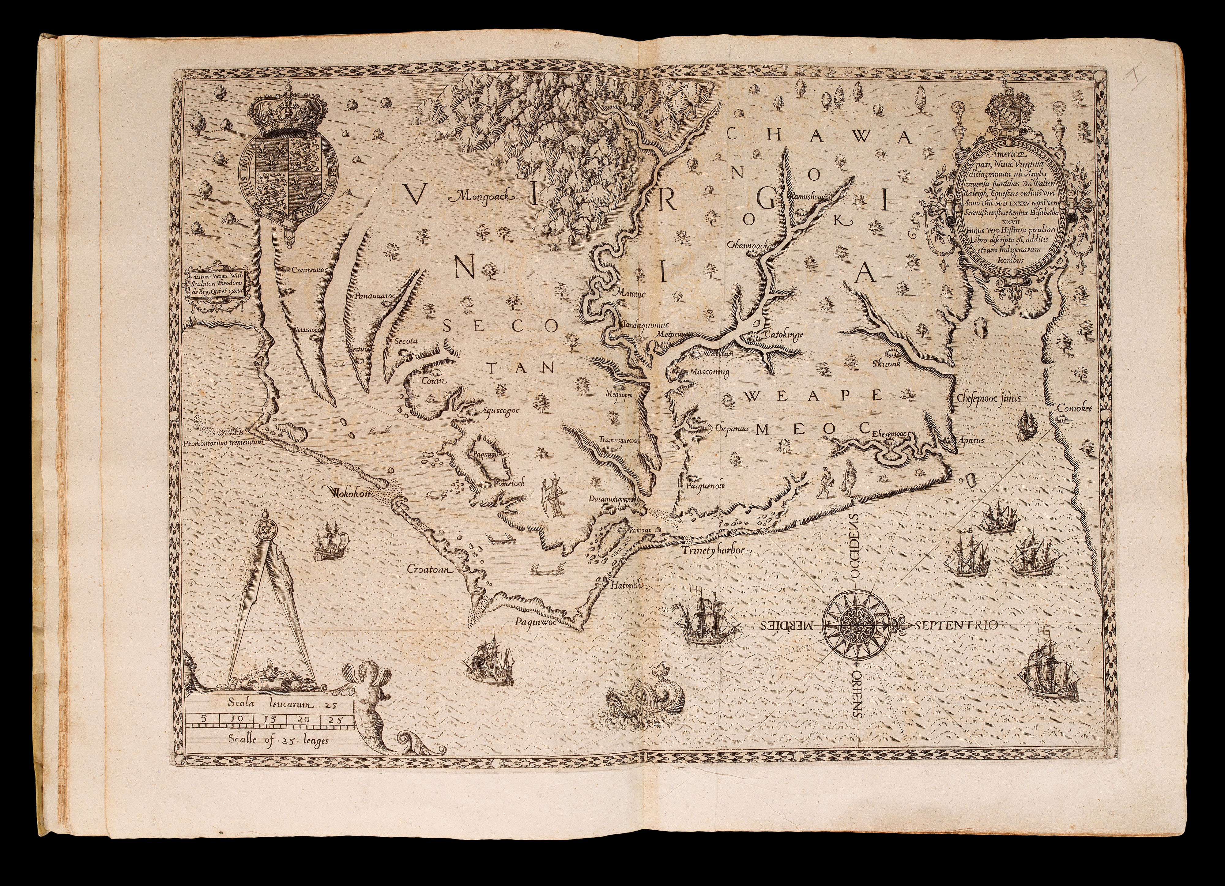
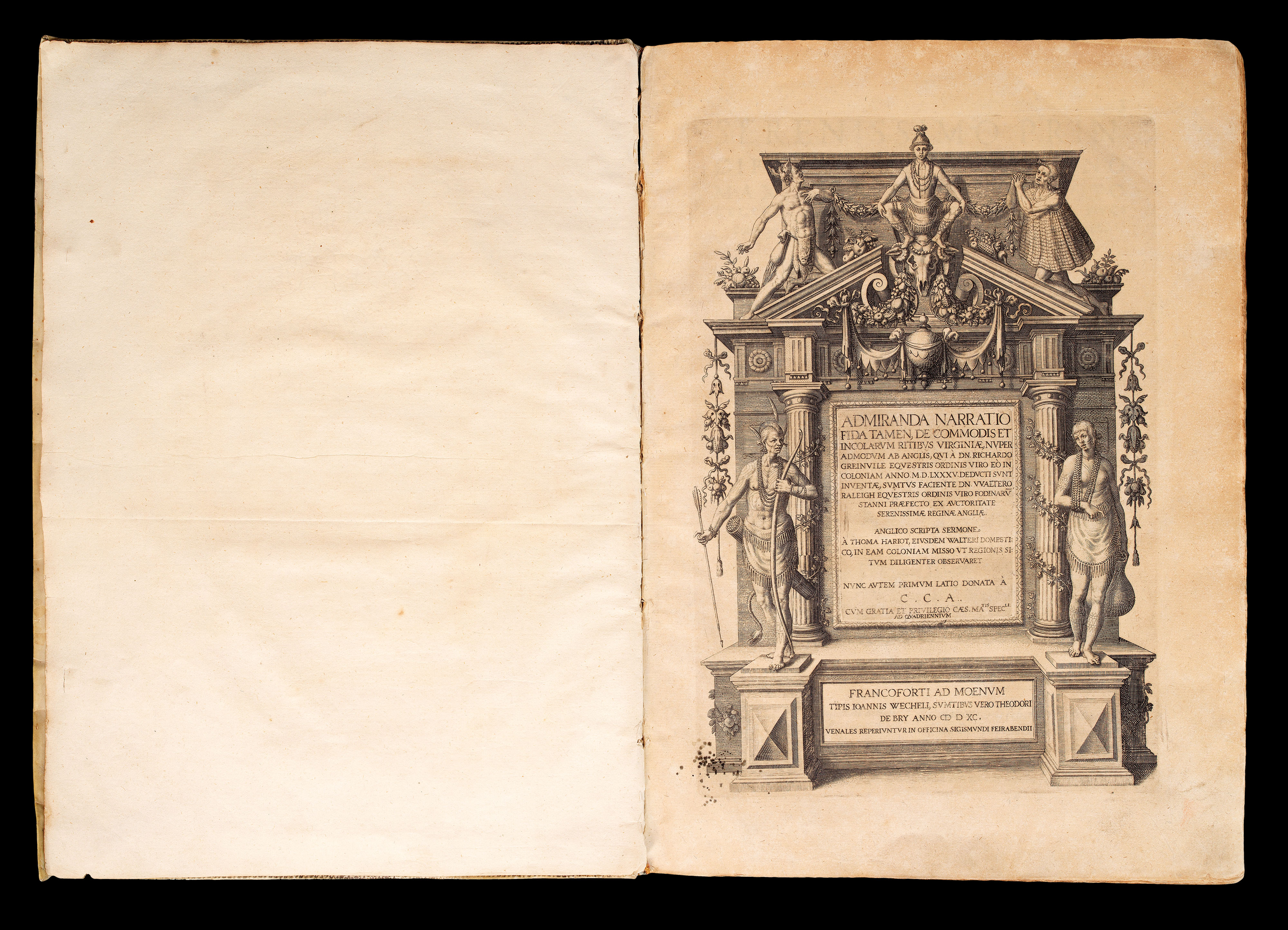
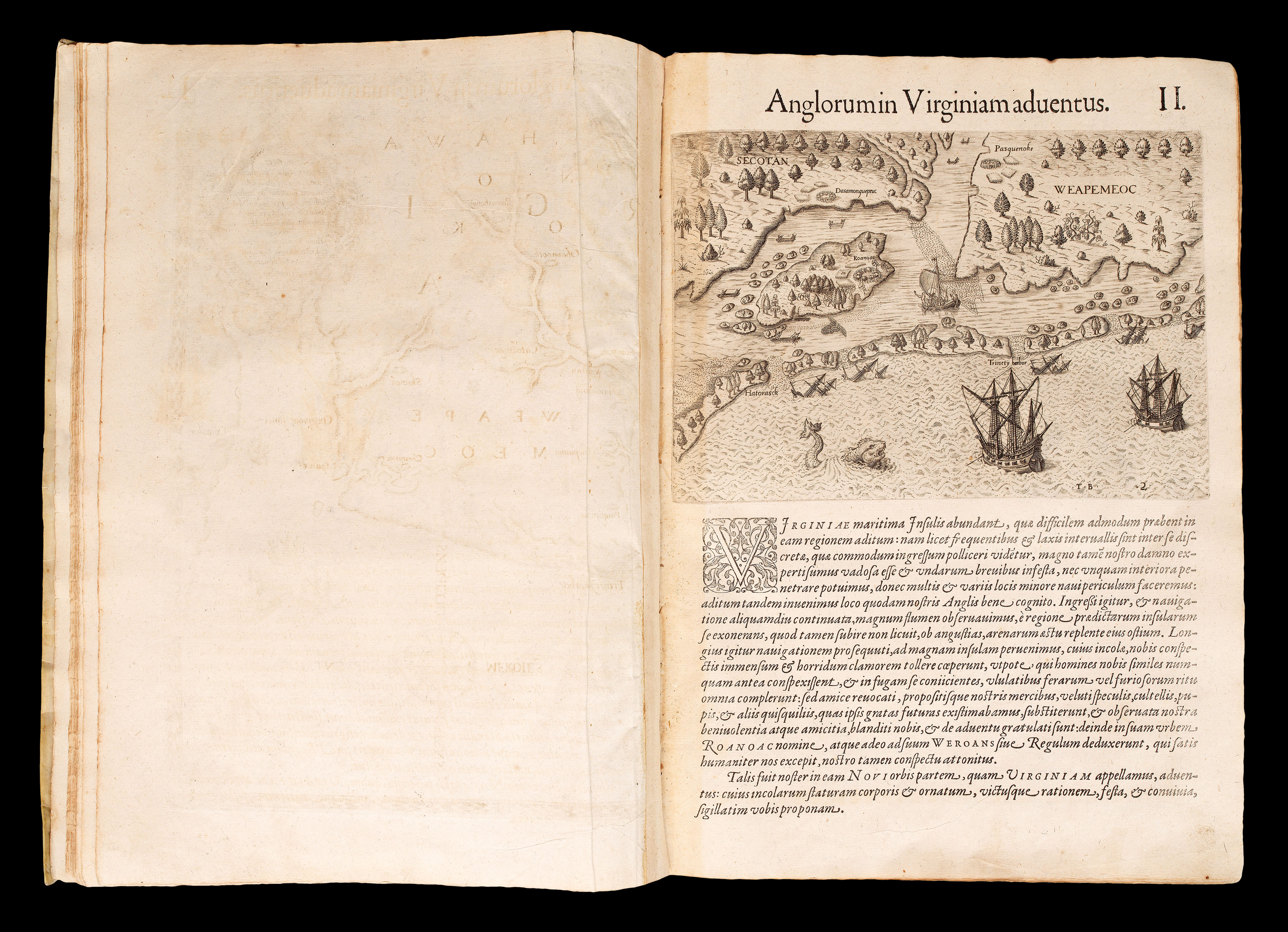
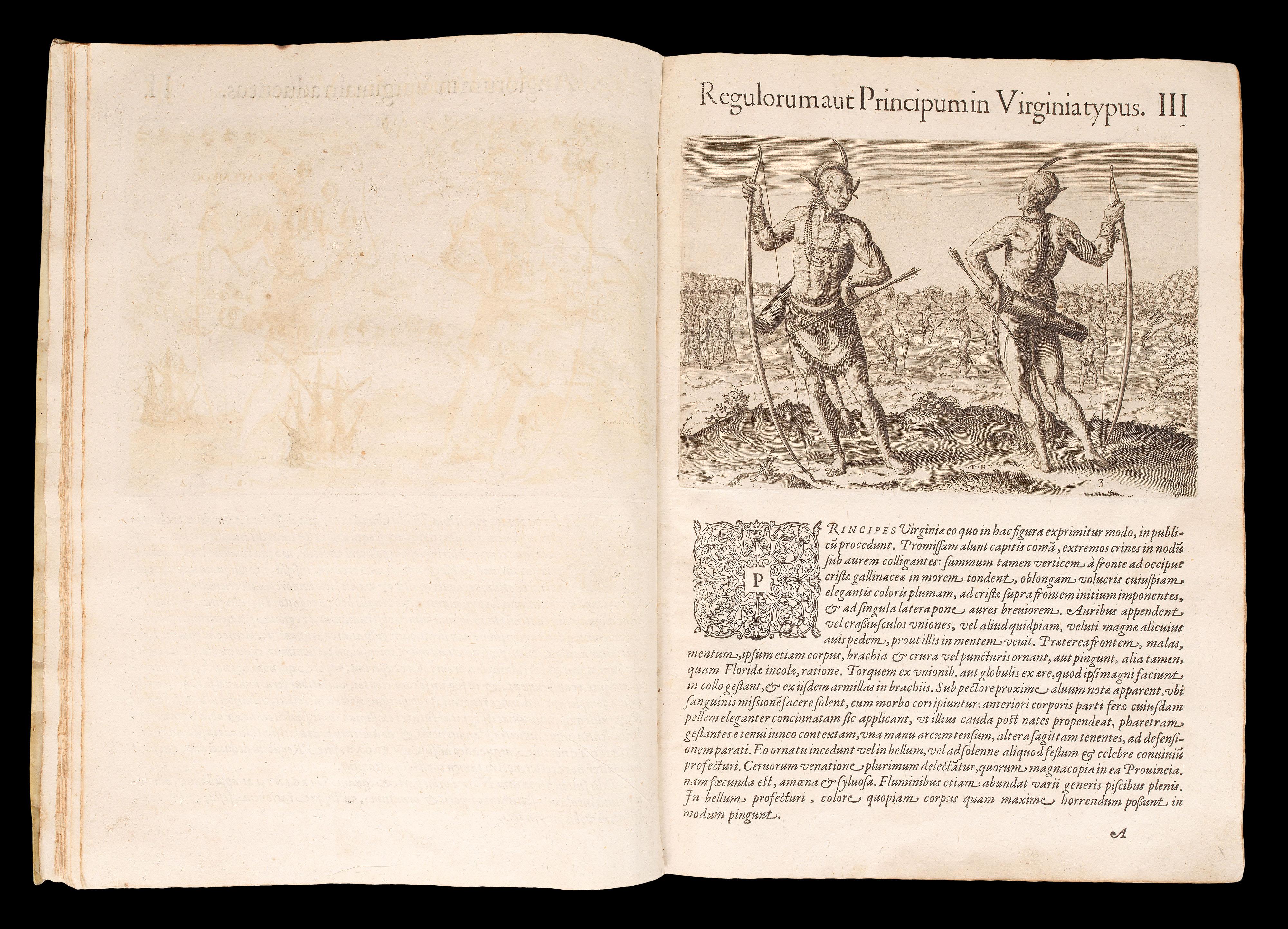
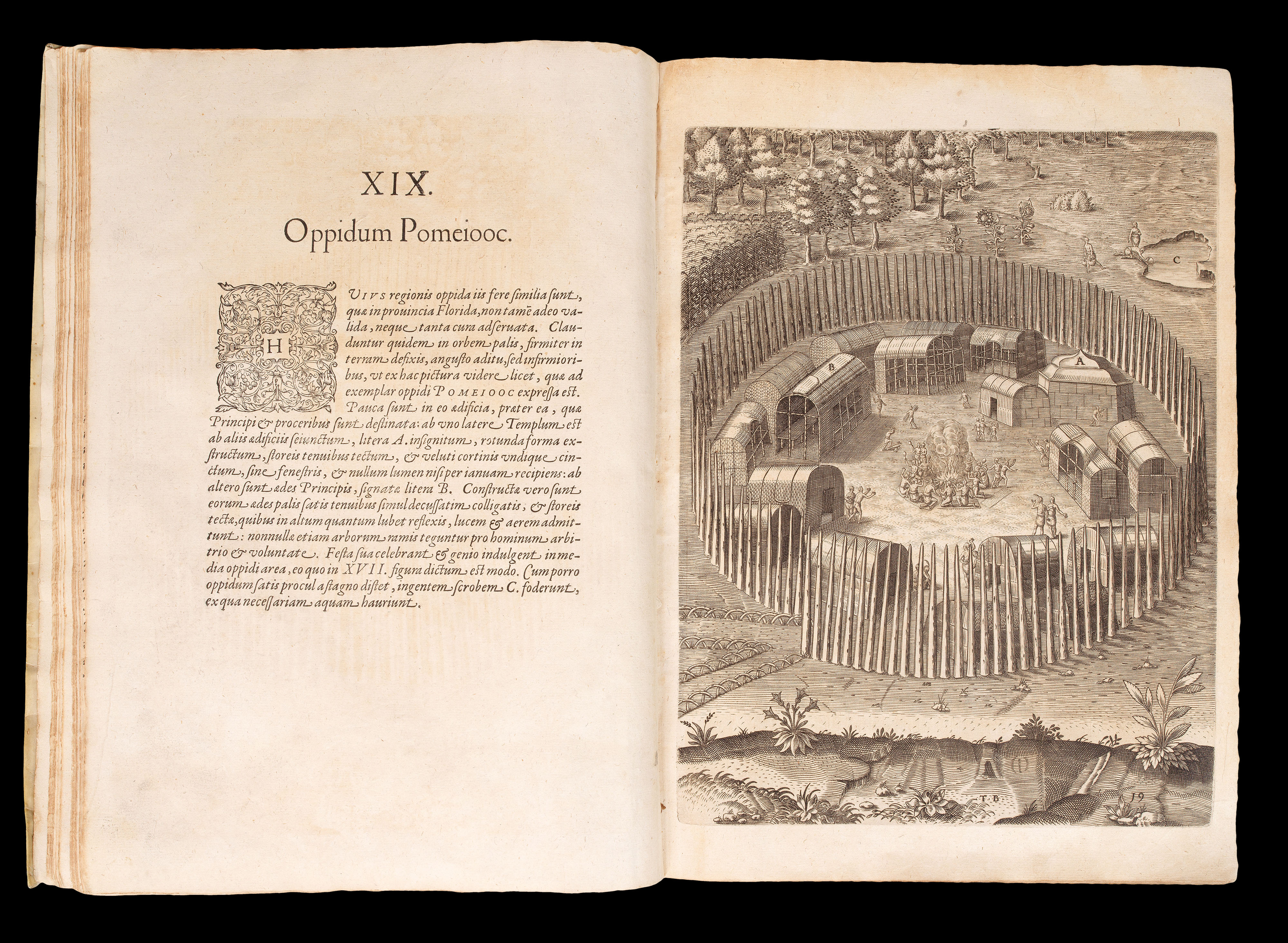
Part I. [Thomas Hariot's Virginia.] 'Admiranda narratio fida tamen, de commodis et incolarum ritibus Virginiae…'. Francoforti ad Moenum, 1590. First edition, first issue. Engraved title-page, engraved arms on dedication leaf, full-page engraved plate of Adam and Eve, double-page engraved map 'Americae pars, Nunc Virginia', 23 numbered engraved plates of local scenes and native Virginians, including 2 double-page and mounted on guards, some full-page, and a further five numbered full-page plates of Picts.
Collation: a4, b6, c4, d8; A-C6, D4, E8, F6; pages [1]-34, leaves [3], map, plates II - XXIII, plates I - V (each interleaved with a single leaf of text), leaves [5].
Thomas Hariot's account of the British Roanoke colony. This is the the first eyewitness pictorial record of the American southeast, the first illustrated account wholly dedicated to any portion of what is now the United States, and provides the best account of the first attempt at British colonization in the New World. De Bry adapted the original watercolors of John White, depicting the Carolina Indians, to illustrate the work. These engravings are the best pictorial record of American Indians before the nineteenth century. The famous map, 'Americae pars, Nunc Virginia', here in the rare first state, is "one of the most significant cartographical milestones in colonial North American history. It was the most accurate map drawn in the sixteenth century of any part of that continent. It became the prototype of the area until long after James Moxon's map in 1671' (Burden 76). This is one of the most important early works on the settlement of North America.
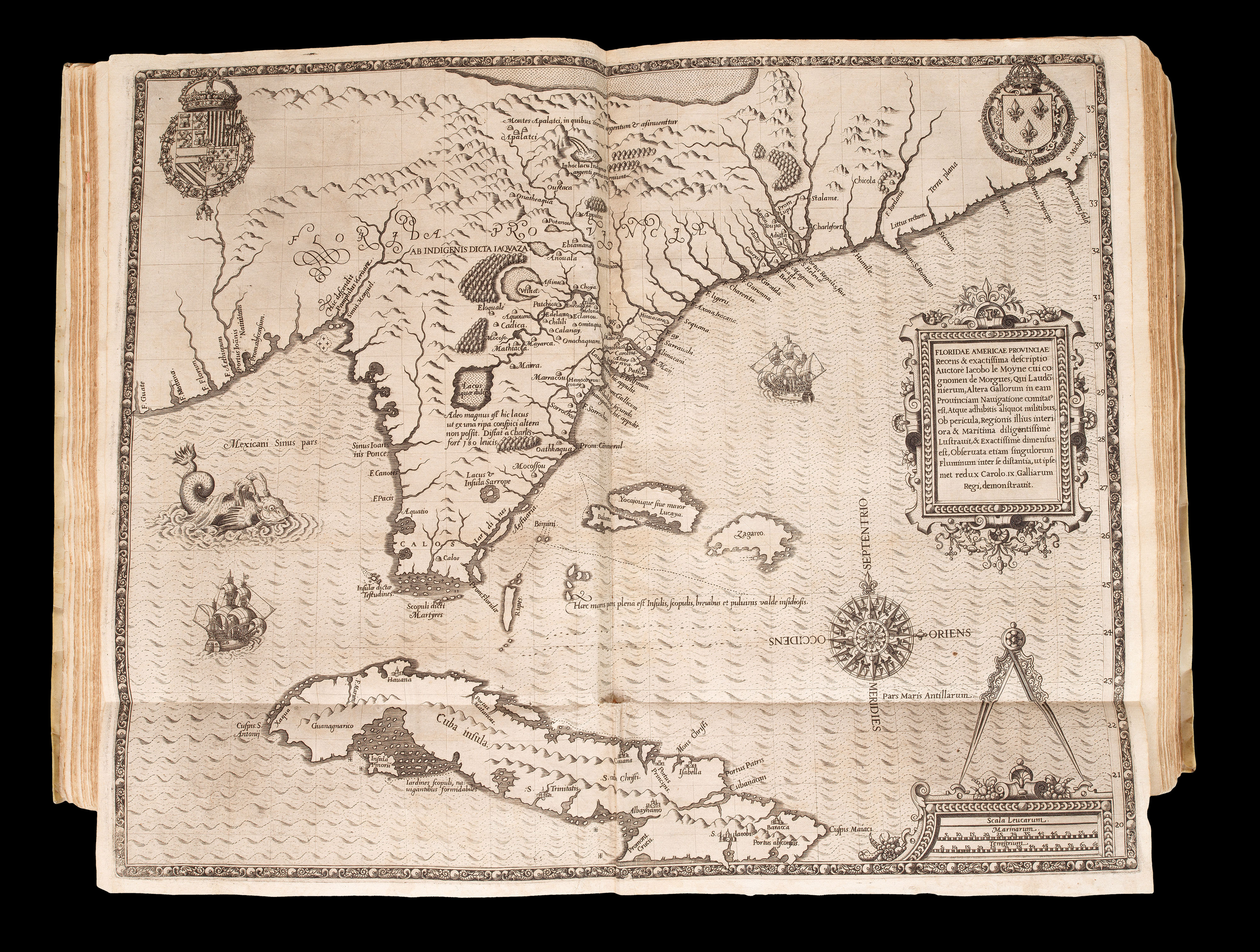
II. [Jacques Le Moyne de Morgues's Florida.] 'Brevis narratio eorum quae in Florida Americae provincia Gallis acciderunt…'. Francoforti ad Moenum: Iohanis Wecheli, 1591. First edition. Engraved title-page, engraved arms on dedication leaf, engraved vignette of Noah offering a sacrifice, engraved title-page, double-page and folding engraved map 'Floridae Americae provinciae', 42 numbered engraved plates of local scenes and native Floridians.
A collection of accounts relating to the attempted settlement of Florida by French Protestants in the 1560s. The text is drawn from the accounts of Jean Ribaut, René de Laudonnière, and Dominique de Gourgues, and describes the foundation of the colony in 1562 and its difficult existence until the massacre of the settlers by the Spanish in 1565. De Bry illustrated this part with engravings after the watercolors of Jacques Le Moyne, depicting the life and ceremonies of the Florida Indians. As ethnographic documents, these are second only to those of John White, as records of American Indian life in the sixteenth century, and like White's work, these illustrations remained unrivalled until centuries later.
The map, 'Floridae Americae provinciae' (Burden 79) which appeared for the first time with this text, is one of the most elaborate of the Florida peninsula to appear in the sixteenth century, giving the names assigned by the French and Spanish. Cumming provides an elaborate description, and John Matthew Baxter describes it as "…the most remarkable and important map, which has been preserved from the sixteenth century maps, of that part of the East Coast which lies between Cape Hatteras and Cape Florida … [It is] the first French map to show Florida … [and is] considered the most important map of Florida".
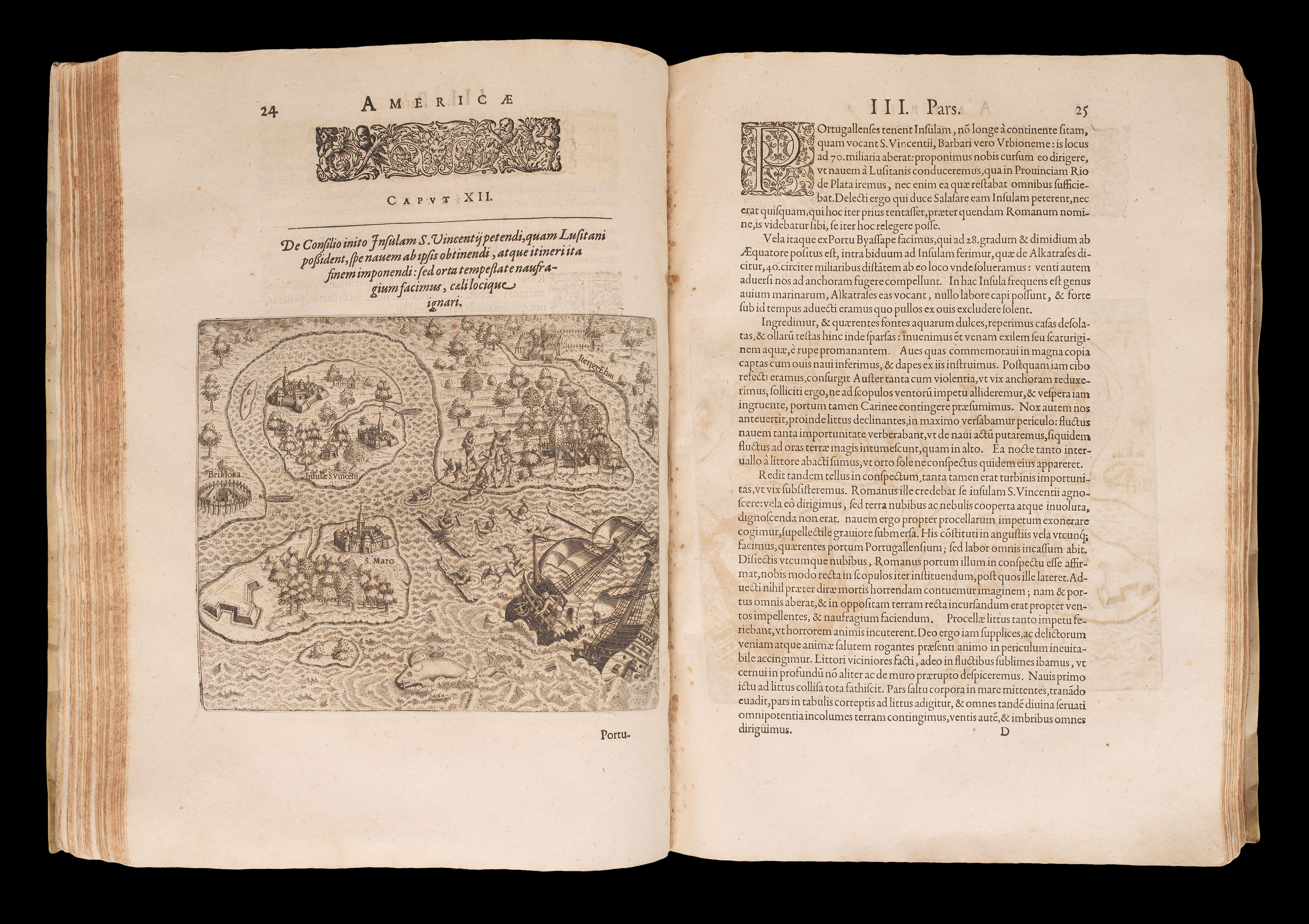
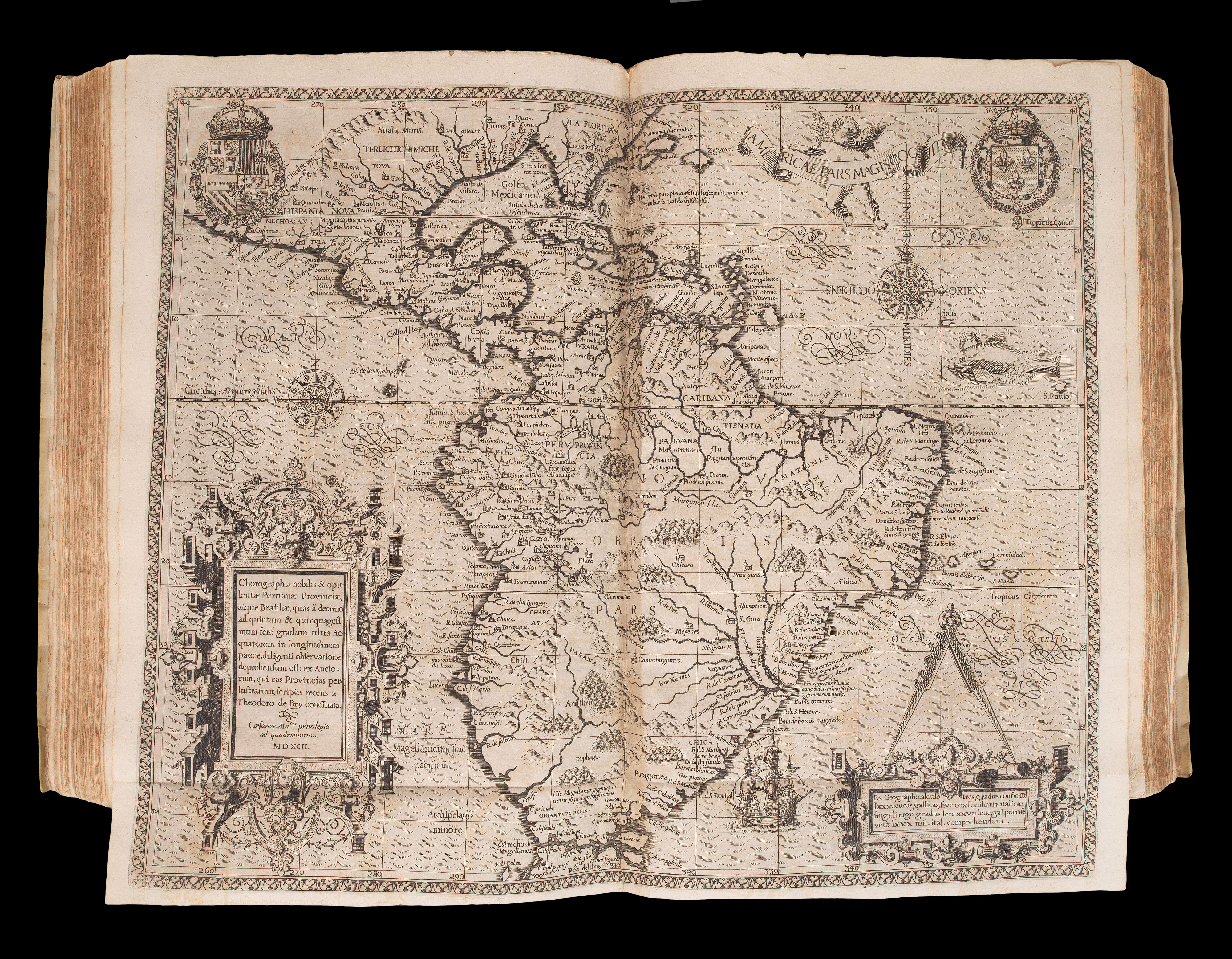
III. [Hans Stadius's Brazil.] 'Americae Tertia Pars Memorabile provinciae...'. Theodori de Bry Leodiensis, atque civis Francofurtensis anno MDXCII (on an overslip)... Venales repernitur in officina Theodori de Bry, [c1597]. First edition, second issue. Engraved title-page, engraved arms on dedication leaf, engraved plate with seven armorials, 35 engraved vignettes, engraved title-page, full-page plate of Adam and Eve, double-page and folding map 'Chorographia nobilis & opulentae Peruanae Provinciae, atque Brasiliae... MDXCII', 10 engraved vignettes, letterpress title-page.
Two accounts related to Brazil. The first is that of Hans Staden, a German mercenary in Portuguese service who was captured by the Tupi Indians. His is one of the first detailed accounts of South American Indians. The De Bry engravings, based on Staden's drawings, are significant ethnographic documents. The second part is the sensitive narrative of Jean de Léry, a French Calvinist minister who lived among the Indians, whose illustrations are also important. This part is a seminal work on the early colonial period in Brazil, illustrated by the first state of the map 'Chorographia nobilis & opulentae Peruanae Provinciae, atque Brasiliae' (Burden 80).
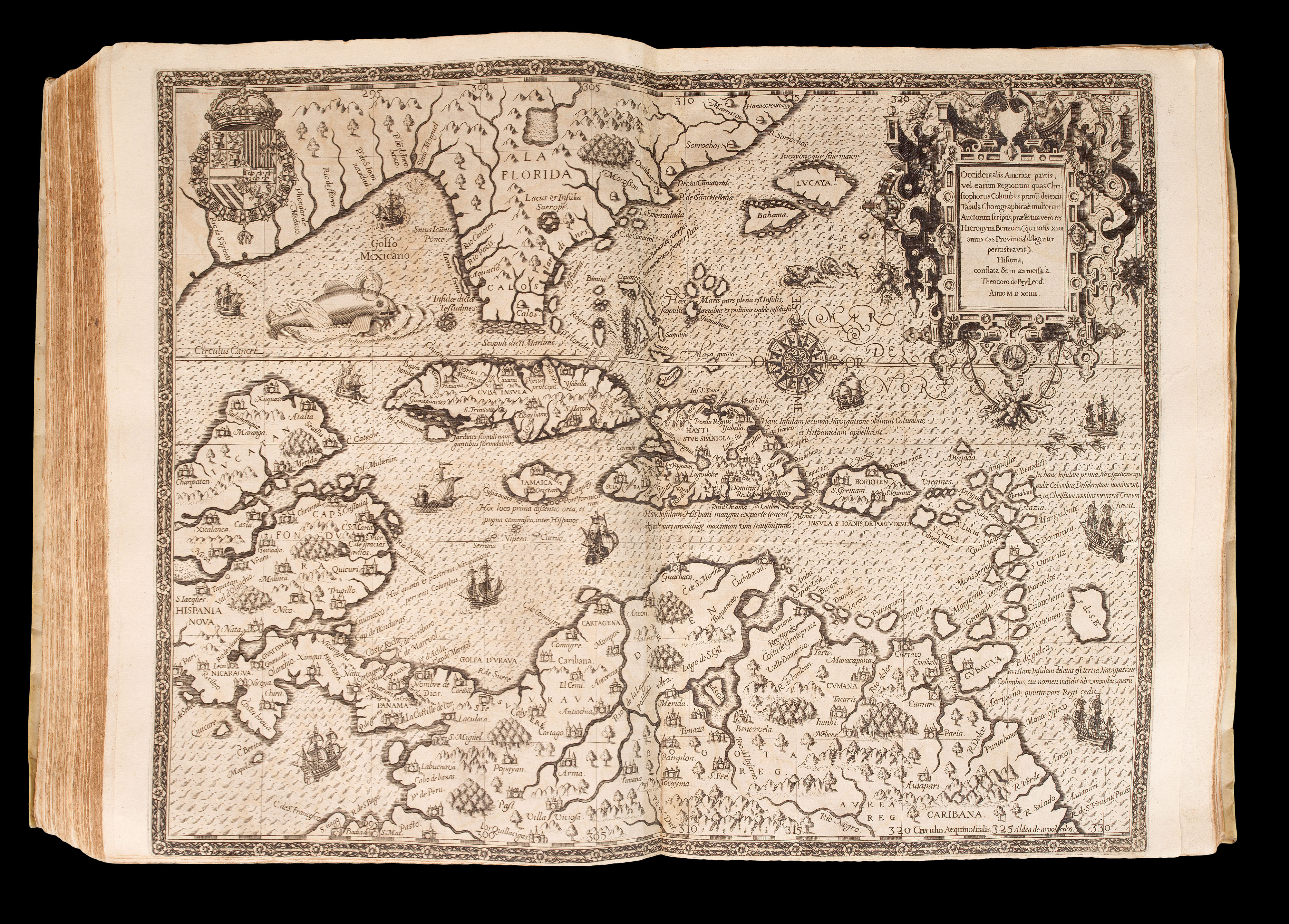
IV. [Girolamo Benzoni's History of the New World.] 'Americae pars Quarta sive, Insignis & Admiranda Historia de reperta primum Occidentali India a Christophoro Columbo anno MCCCCXCII Scripta ab Hieronymo Benzono'. Francofurtensi Anno mb[sic]xciiii [1594]. First edition, first issue. Engraved title-page, engraved plate with seven armorials, engraved vignette of Columbus, engraved vignette 'Americae retectio', engraved title-page, double-page map 'Occidentalis Americae partis', 24 engraved vignettes.
Collation: ):(4, ):():(4, A-Q4, R6 (R6 is blank), A-E4; F6 (F6 is blank); leaves [4], pages 1 - [146], leaves [2], map, plates I - XXIII, leaf [1].
Benzoni's account of his fifteen years of travel in the Isthmus of Panama and Guatemala was first published in Venice in 1565: "It was [written] at the time when the controversy concerning the treatment of the Indians was hottest, and a work, written by one who had just returned from the New World after a stay of fifteen years could not fail to attract attention. In writing it, no standard of criticism was applied; this was not in the spirit of the times. The ultra-philanthropists found Benzoni a welcome auxiliary, and foreign nations, all more or less leagued against Spain for the sake of supplanting its mastery of the Indies, eagerly adopted his extreme statements and sweeping accusations" (Catholic Encyclopedia). The map, 'Occidentalis Americae partis' (Burden 83) illustrates the discoveries of Christopher Columbus.
bibliography:
bibliography:
I. Burden 76, Church 140; II. Burden 79, Church 145; Burden 80, Church 149; Burden 83, Church 153