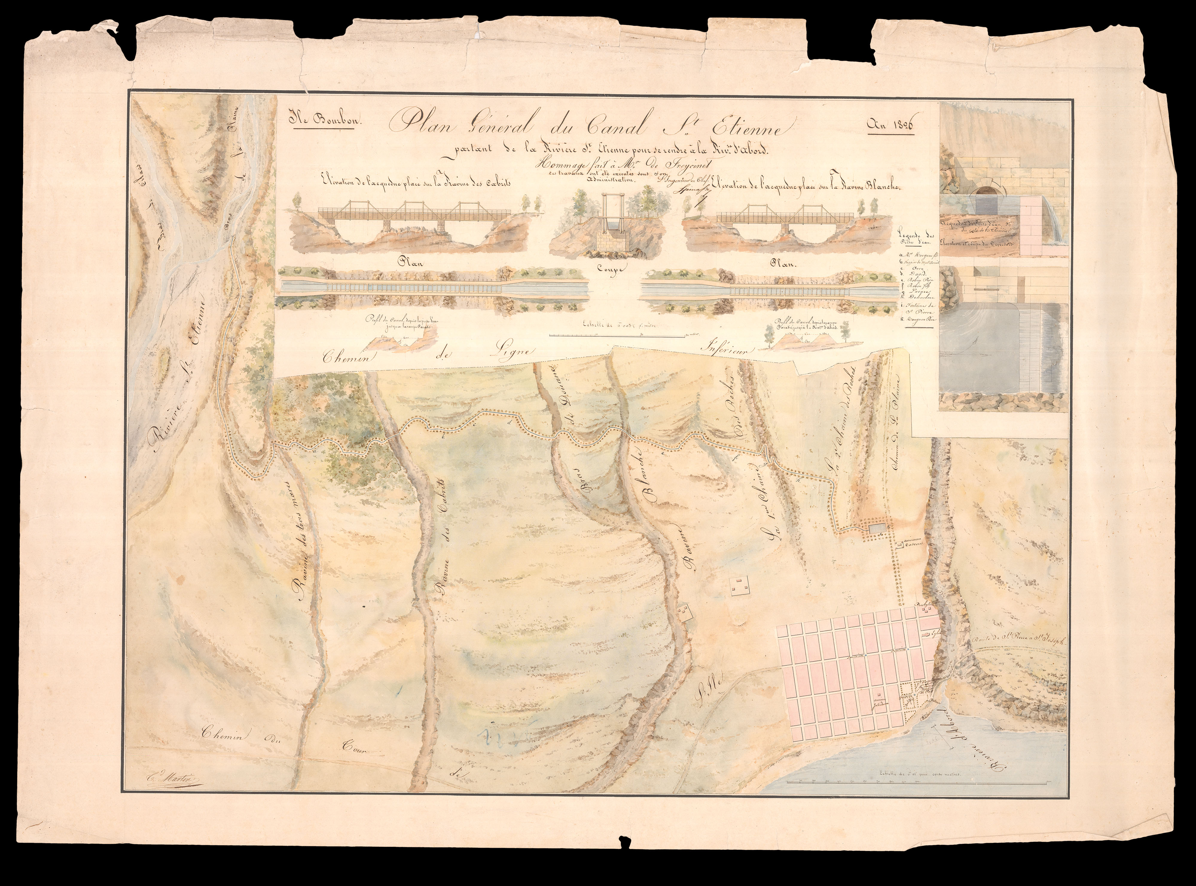
partant de la rivière St. Etienne pour rendre a la Riv.re d'Abord. Hommage fai a Mr. de Freycinet, les traveaux ont ete execute sous son administration. L'Ingenieur en Chef, Heinasse.
A magnificent map of the course of the rivers St. Etienne and d'Abord, on the island of Reunion, surrounded by vignettes of the canal, sometimes elevated, that joins the two. Without doubt created for presentation to Henri Freycinet (1777- 1840), on his retirement as governor of Ile Bourbon, now Reunion, in the Indian Ocean, in 1826. As is stated on the view, work on the canal begun, with the intent of providing water for the sugar distilleries of Saint-Pierre, in 1820 when...
A magnificent map of the course of the rivers St. Etienne and d'Abord, on the island of Reunion, surrounded by vignettes of the canal, sometimes elevated, that joins the two. Without doubt created for presentation to Henri Freycinet (1777- 1840), on his retirement as governor of Ile Bourbon, now Reunion, in the Indian Ocean, in 1826. As is stated on the view, work on the canal begun, with the intent of providing water for the sugar distilleries of Saint-Pierre, in 1820 when Henri arrived to take charge of Reunion.
After the restoration of the monarchy in 1814, Henri Freycinet had embarked on a second career, as a colonial administrator: firstly of the Isle de Bourbon, now Reunion, from 1821 to 1827; then of French Guiana, from 1827 to 1829, during which he was promoted to Rear-Admiral, and Baron; and lastly of Martinique, from 1829 to 1830. He died in Rochefort, Charente- Maritime, in southwest France, in 1840.
Henri Freycinet (1777-1840) was just sixteen years old when he enlisted in the French Revolutionary Navy in 1794. He distinguished himself aboard the 'Heureux', and was promoted to Enseign in 1796. However, the true making of him, and his younger brother Louis, was when they were both appointed to the Baudin expedition to "les terres australes", in 1800; Henri aboard the 'Géographe', and his brother, aboard the 'Naturaliste'. Together they were responsible for charting large swathes of the Western Australian coastline and Tasmania.
On returning to France in 1804, Henri was placed in command of the 'Phaeton'. Initially patrolling the North Sea, his flotilla sailed for the Caribbean in 1805. By early 1806 they had reached Cayenne. On the 25th of March the 'Phaeton' was returning to Santo Domingo when it encountered the British 'Reindeer'. In the ensuing skirmish, Henri was injured in the leg. The following day, the 'Phaeton' was again spotted, this time by the British vessel, the 'Pique', and another skirmish was soon underway. Again, Henri was injured, this time by being shot in the left shoulder, but more significantly by losing his right arm to a canon ball. The 'Phaeton' surrendered, Henri was taken prisoner, and to Jamaica, but by the 12th of June he was back in Santo Domingo, as part of a prisoner exchange.
In July of 1808, Henri was promoted to "capitaine de fégate", and in 1809, took command of the 'Elisa'. In November of 1810, while Henri was attempting to sail from Le Havre meet the main French fleet at Cherbourg, the 'Elisa' ran aground and came under heavy British fire, ultimately foundering on rocks between Tatihou Island and Reville, near La Hougue. Henri was court-martialed, but acquitted, and never commanded an official vessel again.
However, after the restoration of the monarchy in 1814, Henri embarked on a second career, as a colonial administrator: firstly of the Isle de Bourbon, now Reunion, from 1821 to 1827; then of French Guiana, from 1827 to 1829, during which he was promoted to Rear-Admiral, and Baron; and lastly of Martinique, from 1829 to 1830. He died in Rochefort, Charente-Maritime, in southwest France, in 1840.
bibliography:
bibliography:
Archives Departmentales de la Reunion, 'Cartes et Plans (XVIIe-XXe siècle) Inventaire numérique de la série', CP 398
provenance:
provenance:
Provenance 1. Presented to Louis Henri de Saulces de Freycinet, by the chief engineer of the Canal works on the Ile de Bourbon, 1826; 2. Freycinet family archives