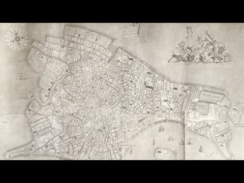
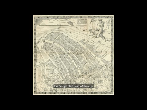
The map shows the city of Amsterdam in the early decades of the sixteenth century, facing south, before the construction of the semi-circular ring of canals. It is bordered by the IJ, the Singel, a stretch of river Amstel, in the west and the Kloveniersburgwal and Gelderse Kade in the east. The waterway in the middle is labelled here “Den Amstel” in the South and “Damrack” in the North.

Feb
One of the largest maps of Venice ever published, and the first map of the city based upon accurate field surveys. Lodovico Ughi’s topographical map is a landmark in the cartographic history of Venice. Successive Venetian mapmakers in general did not significantly alter the appearance of the city: among the exceptions is Ughi’s work. Not only is it one of the largest printed plans of Venice, but it also served for centuries as a model for subsequent maps.

Jan
Popple’s 20 sheet ‘Map of the British Empire in America’ is one of the two most important large format maps of North America published in the eighteenth century. Along with John Mitchell’s ‘Map of the British & French Dominions in North America’, the map was a profound statement of England’s designs for dominance of the North American continent; at a time when colonial control of North America was by no means certain.

Jan
An extraordinarily rare cartographic document that is based on research originally presented to the Qianlong emperor by Huang Qianren (fl. 1760- 70) in 1767. The title of the map is as much a political programme of the Qing as it is a geographical record. It shows China at the height of the Qing empire, celebrating the “unified status of all of Chinese borders” (Pegg).

Jan
A monumental Chinese celestial chart Huntian yitong xingxiang quantu, one of the largest planispheres published during the Qing dynasty (1636-1912). The work combines both Chinese and Western astronomy, highlights the fundamental role that knowledge of the heavens played in Chinese politics, and illustrates the Qing dynasty’s endeavours to seek authentic truth in ancient texts.

Nov
Mitchell’s map is widely regarded as the most important map in American history. Prepared on the eve of the Seven Years’ War (or French and Indian War), it was the second large format map of North America printed by the British (the first being Henry Popple’s map of 1733), and included the most up to date information of the region: “the result of a uniquely successful solicitation of information from the colonies” (Edney). Over the following two hundred years, it would play a significant role in the resolution of every significant dispute involving the northern border of the then British Colonies and in the definition of the borders of the new United States of America.

Nov
The finest of the eighteenth century plans of Rome and the first plan of the city based upon geodetic principles.

Oct
Printed on twenty-four sheets of paper and measuring some two by four metres, Rocque’s 1746 map is the first large-scale survey of the cities of London, Westminster, and Southwark.
Incredible in both scale and detail, the plan stretches west to east from Hyde Park to Limehouse and north to south from New River Head to Walworth.

Oct
For the 2020 online edition of Frieze Masters, we are delighted to dedicate our exhibition to a rarely celebrated art form: the eighteenth century baroque town plan.
The town plans of the eighteenth century reveal developments in urban cartography and reflect a new, planned, shape for the world’s great cities. These ‘new’ cities significantly restructured the historic medieval and Renaissance centres and greatly expanded the built-up area.
‘Baroque’ town planning in European cities answered the needs of the grandiosity demanded by the megalomania and triumphalism of the absolutist monarchies of the time, as well as the demographic changes that had to be faced.
The collection comprises massive wall maps of Amsterdam, Berlin, London, Madrid, New York, Paris, Rome, and Venice.

Jul
A chart case from the Her Majesty’s Yacht Victoria and Albert (II), containing 284 charts, covering the entire globe, and demonstrating The British Admiralty’s mastery of the seas at the height of the British Empire.
The chart case contains 10 pilots providing detailed charts for navigation from the British Isles to: Africa and the Cape of Good Hope; North America and the West Indies; Australia; China; The East Indies; The Pacific; The English Channel and Ireland; The Mediterranean; The English Channel, North Sea and Baltic; and The South East Coast of South America. Ranging from 30 charts contained in the China pilot to a mere 14 charts in the Africa pilot.