Luis Teixeira’s Magna Orbis Terrarum Nova of 1604

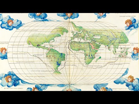
A spectacular wall map of astonishing beauty made at the beginning of the Dutch Golden Age.

The present map draws on the cartography of Luis Teixeira (fl.1564-1613) – whose name appears in the large pasted title – a Portuguese cartographer from a famous mapmaking dynasty. He worked in Lisbon and the Portuguese colonies, but was also a friend of and collaborator with Dutch cartographers, contributing a map of Japan to Abraham Ortelius’ atlas. Ortelius and Cornelis Claesz published five of his maps between them, and all were specifically advertised as based on his work, indicating that he was highly respected in Amsterdam.

The map is based upon a simple cylindrical projection and follows very closely the 1592 wall map drawn by Petrus Plancius, “a milestone in the emergence of Dutch cartography [and] the first large wall map of the world to be published in the north” (Schilder).

A composite atlas of Italy, bound for Louis, Dauphin of France

Louis (1729–1765) was the only surviving son of King Louis XV of France and his wife, Queen Marie Leszczyńska. Son of the king, Louis was styled Fils de France, and as heir apparent, he became Dauphin of France. However, he died before ascending to the throne. Three of his sons became kings of France: Louis XVI (reign: 1774–1792), Louis XVIII (reign: 1814–1815; 1815–1824) and Charles X (reign: 1824–1830).

The atlas covers Italy, Sicily, Sardinia, Corsica, and Malta. The maps range in date from 1653-1753, with the majority dating from the first half of the eighteenth century. All but three maps (two by Homann and one by the Spanish cartographer Chafrion) are by the leading French cartographers of the day, these include De Fer, Jaillot, Delisle, Du Val, Le Rouge, and Nolin.

Bernard Ratzer’s plan of New York

“Perhaps the finest map of an American city and its environs produced in the eighteenth century” (Augustyn).

The new plan, first published in 1770, lays out a city of about 25,000 inhabitants and its surrounding farmland. It offers a remarkably accurate view of the streets of lower Manhattan and depicts the farms, roads and topography reaching to approximately present day 50th Street; along with the marshy New Jersey shores of the Hudson; Kennedy, Bucking and Governors Islands; and parts of present day Brooklyn along the East River. The map is paired with an idyllic panoramic view of the city from Governors Island.

Astronomique Discourse

First edition of the Scotsman James Bassantin’s (c1500-1568) copiously illustrated, large-format compendium on calculating planetary positions. From the library of Mary, Queen of Scots, bound in Paris with her crowned initial, and with all the illustrations in fine contemporary hand-colour.

A magnificent portolan atlas by Batista Agnese

This atlas is in its original Agnese binding, and it can confidently be stated that the order of the sheets is just as Agnese originally produced it: it contains the more or less standard preliminary pages found in most Agnese atlases, including a table of the declination on the sun, an armillary sphere, and a circular zodiacal calendar.

Show me a map by Tin Pan

Celebrating our fifth anniversary, we hope you enjoy the video and soundtrack, which has been specially written for the occasion by our favourite New York band: Tin Pan.

Matteo Ricci’s monumental world map of 1602

London map expert Daniel Crouch lectures on the Ricci map at the MIA. This lecture is co-presented by the Minneapolis Institute of Art, the Associates of the James Ford Bell Library and the James Ford Bell Library of the University of Minnesota Libraries.